

Red Rock State Park
75 Raven's Call Pl, Sedona, AZ
Sedona, AZ
A green ribbon of Oak Creek winding beneath Sedona's red cliffs, protected as a quiet nature preserve where the crowds thin and the birds take over.
Red Rock State Park protects a stretch of Oak Creek just outside Sedona, where the year-round water supports a rich green corridor of cottonwoods, sycamores, and willows beneath the red sandstone cliffs the region is known for. Managed as an environmental education preserve rather than a recreation free-for-all, it is deliberately quieter than Sedona's crowded viewpoints, and its network of gentle loop trails invites a slower, more attentive kind of visit.
The park's real specialty is the meeting of water and desert. Oak Creek is a rare permanent stream in an arid land, and the ribbon of green life it sustains stands in vivid contrast to the dry, red country around it. That contrast makes the park a haven for birds and other wildlife, and a fine place to understand how a single creek can shape an entire community of living things in the high desert of central Arizona.
What Travelers Love
- Shaded creekside trails beneath cottonwoods and sycamores, cool even in summer
- Red-rock views without the crowds of Sedona's most famous spots
- Excellent birdwatching along the water and in the meadows
- Ranger-led walks and a nature center that explain the creek and the desert
Worth Knowing
- This is a preserve focused on nature and education, so activities like swimming and dogs are more restricted than at some parks
- Trails are gentle and well-marked, good for families and easygoing walkers
- The park is separate from Sedona's red-rock trailheads; it offers a quieter, greener experience
- Bring binoculars; the riparian corridor is a magnet for birds
Learn about Red Rock State Park
Where water meets red rock
The heart of the park is Oak Creek, which flows down from the pine country to the north through Sedona's red-rock canyons and on toward the Verde River. Because it carries water all year, its banks support a lush green corridor, a riparian forest of tall trees and dense understory that could not exist without the stream. In the desert Southwest such places are rare and precious.
Above that green ribbon rise the red cliffs and buttes that make Sedona famous. The park's trails weave between the two, along the shaded creek and out through drier meadows with open views of the formations. That constant interplay of cool water and warm rock is what gives the park its distinctive, restful character.
The story of the land
The red-rock country around Sedona lies within a landscape long known to Native peoples, including the ancestors of today's Yavapai and Apache, whose descendants are enrolled in the Yavapai-Apache Nation, as well as earlier cultures whose cliff dwellings and rock art survive in the wider region. The permanent water and sheltered canyons of the area made it a place worth knowing and returning to.
In more recent times the land that became the park was a working ranch along Oak Creek, and later it was set aside and developed as a state park focused on environmental education. That purpose shapes everything about the place today, from the ranger-led walks and school programs to the restraint that keeps it green and quiet rather than crowded and worn.
Birds, wildlife, and the creek
The riparian corridor along Oak Creek is one of the best places near Sedona to watch birds. Water-loving and woodland species gather in the trees and along the banks, and migrating birds pass through with the seasons, making the park a favorite for birders. Herons, hawks, songbirds, and many others can be seen with patience and binoculars.
Beyond the birds, the creekside woods and adjoining meadows shelter deer, javelina, and a range of smaller desert wildlife, most active in the cool of morning and evening. The nature center and interpretive walks help visitors understand how the creek, the plants, and the animals fit together, turning a pretty walk into a deeper look at how the high desert lives on its water.
Season by season
Spring is green and mild, with the creekside trees leafing out and birds passing through on migration, a lovely time for the gentle trails. Summer days can be warm, but the shade along the creek keeps the streamside paths comfortable when the open country is hot.
Fall brings golden cottonwoods and sycamores glowing against the red rock, one of the prettiest times to visit. Winter is cool and quiet, with crisp, clear days, occasional dustings of snow on the red cliffs, and the fewest visitors of the year, ideal for a peaceful walk beside the water.
Closest Boutels
The closest Boutel™ stays, so you can turn this stop into an overnight. Each is a place we chose through independent editorial review, never a paid placement.
The Iron Horse Inn
Boutel1034 N Main St, Cottonwood, AZ 86326, Cottonwood, AZ
12 miles away|Learn More ›
Details
Sedona, AZ
Frequently asked questions
What is Red Rock State Park?
Red Rock State Park, just outside Sedona, Arizona, is a lovely nature preserve and environmental education center set along the banks of Oak Creek amid the area's famous red-rock scenery. Unlike Sedona's busier trailheads, this quieter park focuses on gentle hiking, birdwatching, and learning about the region's ecology, with well-maintained trails winding through riparian woodland, meadows, and rolling red-rock terrain. With ranger-led programs, a visitor center, and peaceful creekside beauty, it offers a relaxed, family-friendly, and educational way to enjoy Sedona's landscape.
What can you do at Red Rock State Park?
You can hike a network of gentle, interconnected trails through green creekside forest, meadows, and up to scenic red-rock overlooks, watch for the abundant birds and wildlife along Oak Creek, join ranger-led nature walks and educational programs, and explore the visitor center's exhibits. Picnicking and photography are popular too. Because the park emphasizes nature study and preservation, it offers a calmer, more contemplative experience than Sedona's crowded hot spots, making it ideal for families, birders, and those seeking scenery without the crowds.
Can you swim at Red Rock State Park?
No, swimming and wading are not permitted in Oak Creek within Red Rock State Park, since it is a protected nature preserve focused on habitat and education rather than water recreation. Visitors who want to swim or slide in Oak Creek should head to nearby Slide Rock State Park up in Oak Creek Canyon instead. At Red Rock State Park, the creek is enjoyed for its scenery, birdlife, and the riparian habitat it supports, viewed from the trails rather than entered.
When is the best time to visit Red Rock State Park?
Spring and fall offer the most comfortable temperatures for hiking the trails, with spring greenery and fall color along the creek especially lovely, while summer is warm, so morning visits are best then, and winter is mild and quiet. Mornings are prime for birdwatching and cooler walking. The park's gentle trails and shade along the creek make it pleasant across seasons, but the milder months and cooler hours provide the most enjoyable experience of its scenery and wildlife.
What is near Red Rock State Park?
The park is just southwest of Sedona, near the town's famous red-rock landmarks like Cathedral Rock, Bell Rock, and the Chapel of the Holy Cross, its galleries and shops, and the scenic Oak Creek Canyon drive with Slide Rock State Park for swimming. The Verde Valley's Jerome and ancient sites lie nearby. That makes Red Rock State Park a peaceful, nature-focused stop to combine with Sedona's iconic formations and the surrounding attractions on a northern Arizona visit.
Outside the Park

Cathedral Rock
2.4 miles away
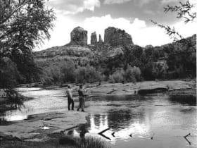
Cathedral Rock is the most-photographed rock formation in Arizona. The classic shot is from the Red Rock Crossing area of Oak Creek, with the twin spires reflected in the water.
Red Rock Scenic Byway
3.1 miles away
Red Rock Scenic Byway follows AZ-179 for about seven miles between the Village of Oak Creek and Sedona, threading past some of the most photographed red rock in the Southwest.

Bell Rock
3.8 miles away
Bell Rock is one of Sedona's most iconic butte formations, and one of the few where scrambling on the rock itself is allowed and common.
Chapel of the Holy Cross
3.8 miles away
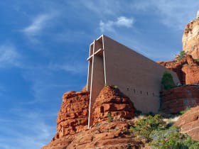
A modernist chapel built straight into the red rock buttes just south of Sedona, with a ninety-foot cross for a spine and a glass wall framing the Verde Valley.
Boynton Canyon
6.7 miles away
Boynton Canyon is one of Sedona's premier day hikes - 6 miles round-trip through a lush canyon that ends in a box with high red walls. The Enchantment Resort sits midway through the canyon.
Slide Rock State Park
9.6 miles away
The main feature at Slide Rock State Park is a natural water slide worn smooth by Oak Creek flowing over sandstone slabs for centuries.
Oak Creek Canyon
12 miles away
Oak Creek Canyon runs from Sedona north to the Mogollon Rim, dropping 3,400 feet in 16 miles.

Tuzigoot National Monument
12 miles away
Tuzigoot is a hilltop pueblo of 110 rooms occupied by the Sinagua people for nearly 300 years.
Dead Horse Ranch State Park
12 miles away
A cool, green riverside state park on the Verde River just outside Cottonwood, with three fishing lagoons, shady cottonwood trails, and some of the best birding in Arizona.
Oak Creek Canyon Overlook
12 miles away
The first overlook on US-89A heading south from Flagstaff into Oak Creek Canyon appears after the switchbacks at 6,400 feet and gives a full view into the canyon before the road descends.

Montezuma Well
12 miles away
Montezuma Well is a detached unit of Montezuma Castle NM - a 350-foot-diameter limestone sinkhole fed by a subsurface spring at 1.5 million gallons per day.

Montezuma Castle National Monument
14 miles away
Montezuma Castle is one of the best-preserved cliff dwellings in North America.
Verde Canyon Railroad
15 miles away
Verde Canyon Railroad runs a 4-hour, 40-mile excursion through the Verde Canyon, which has no road access - train is the only way in.
Palatki Heritage Site, Sedona area
16 miles away
Palatki has two adjacent sites: a Sinagua cliff dwelling occupied 1150-1350 CE, and a shelter with 6,000 years of painted pictographs in overlapping layers.

Sycamore Canyon Wilderness
16 miles away
Sycamore Canyon is a 21-mile wilderness canyon with a perennial creek, sycamore-cottonwood gallery forest, and red rock walls.

Jerome
17 miles away
A former copper boomtown stacked up the side of a mountain, once branded the wickedest town in the West and now an artists' colony full of galleries and ghost stories.

Jerome Grand Hotel
17 miles away
The Jerome Grand Hotel occupies the 1926 United Verde Hospital, built by the Phelps Dodge Corporation on the most prominent point in Jerome at 5,200 feet.

Fort Verde State Historic Park
18 miles away
Fort Verde preserves several original 1870s adobe buildings from an Apache Wars era army post, arranged around a parade ground you can cross in a few minutes.
Mingus Mountain Viewpoint
19 miles away
Mingus Mountain rises on the north flank of the Black Hills above the Verde Valley and has a series of viewpoints accessible from US-89A on the switchbacking road between Prescott and Jerome.
Historic Route 66, Flagstaff to Winslow
47 miles away
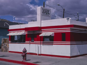
The Route 66 alignment east of Flagstaff passes through Winona (you need to know it) and ends at the famous Standin' on the Corner park in Winslow.