
Red Rock Scenic Byway
Arizona
Some roads take you somewhere. The Red Rock Scenic Byway is somewhere, a rolling ribbon of Arizona State Route 179 that carries you straight into the crimson heart of Sedona's red rock country. In roughly seven and a half miles you pass beneath towering buttes of iron-stained sandstone, past juniper and pinyon pine, with a new sculpted formation filling the windshield around nearly every bend.
This is a drive the federal government singled out as one of America's finest, a route so striking it is often called a destination unto itself. Whether you crawl it at sunset or roll through at midday, it is one of the most photographed stretches of pavement in the American Southwest, and an unforgettable approach to any stay in Sedona.
Learn about Red Rock Scenic Byway
The Road
State Route 179 is a two-lane state highway that climbs north out of the high desert toward Sedona. The scenic byway portion, the part that earned the honors, runs about seven and a half miles from the Village of Oak Creek up to the edge of Sedona, threading through the Coconino National Forest the whole way. It is the gateway drive, the road most travelers take to reach the red rocks from Interstate 17 to the south.
The driving experience is unusually relaxed for a route this famous. Instead of stoplights, the byway uses a series of roundabouts that keep traffic flowing at an easy, unhurried pace, which happens to be the perfect speed for gawking at the scenery. Several of those roundabouts now hold public sculptures, and generous pullouts and vista points let you stop and take in Bell Rock, Courthouse Butte, and Cathedral Rock without holding up the car behind you.
What makes SR 179 special is how much it packs into so short a distance. A paved multi-use path runs alongside much of the corridor, so walkers and cyclists share the views. Trailheads for some of Sedona's most beloved hikes open right off the road. And the red rocks themselves are constant company, close enough to feel monumental, changing color hour by hour as the desert light shifts from morning gold to fiery late-afternoon red.
How to Get There
There are two main ways onto the Red Rock Scenic Byway, and both are easy to find. Coming from Phoenix, drive north on Interstate 17 to Exit 298 at the Village of Oak Creek. State Route 179 begins right there and heads north into the red rocks, so the drive starts the moment you leave the freeway.
Coming from Flagstaff, take State Route 89A south and wind down through Oak Creek Canyon into Sedona. The byway starts at the Y intersection where 89A meets 179 in the center of town, and you follow it heading south. Travelers arriving from the west, through Cottonwood and the Verde Valley, also reach the same Y intersection on 89A.
Either direction is a fine choice, but many people like to enter from the Village of Oak Creek so the buttes rise up in front of them the whole way into Sedona.
History
The route we now call the Red Rock Scenic Byway was established as State Route 179 in 1960, when Arizona reorganized its highway numbering. For decades it was simply the practical way into Sedona from the south, a workaday road running from the interchange near Camp Verde up through the community that locals long called Big Park, later the Village of Oak Creek, and on to the famous Y intersection where it meets State Route 89A in the heart of Sedona.
Its national moment came on September 22, 2005, when the Federal Highway Administration named it an All-American Road, the very highest honor in the country's scenic byway system. It was the first road in all of Arizona to earn that distinction, reserved for routes with features so exceptional they are considered a destination in their own right. Only a few dozen roads nationwide hold the title. The designation recognized the byway's rare combination of scenic, natural, recreational, cultural, and historic qualities, all concentrated along one short desert highway.
Right around that same time, the road itself was reborn. Through the 2000s, the Arizona Department of Transportation carried out a major SR 179 improvement project, working closely with a famously involved local community that wanted the rebuilt highway to protect the very views it framed. The result, with its main sections completed around 2008, replaced traffic signals with a chain of roundabouts, added the paved multi-use path, and treated the whole corridor as a designed gateway meant to slow travelers down and hand them the scenery rather than rush them past it. The stretch through the Village of Oak Creek became both the welcoming front door to Sedona's red rock country and, in effect, the village's own main street.
The rocks that make it all worth the trip are older than any highway by an unimaginable margin. Sedona's signature red buttes are carved largely from the Schnebly Hill Formation, a thick body of sandstone laid down some 280 million years ago from ancient wind-blown dunes and shallow seas. Their glowing color comes from hematite, a form of iron oxide. A whisper-thin film of it coats the sand grains, and that trace of rust is all it takes to turn ordinary pale stone into the deep, burning red that gave the byway its name. Perched on one of those red spurs sits the Chapel of the Holy Cross, completed in 1956. It was the vision of sculptor Marguerite Brunswig Staude, who moved in Frank Lloyd Wright's circle and dreamed of a church that seemed to grow from the rock itself. Rising between twin pinnacles high above the road, it remains one of the most beloved landmarks the byway serves.
Little-Known Facts
- The Red Rock Scenic Byway was the very first road in Arizona to earn the All-American Road designation, the highest honor in the country's scenic byway system, granted on September 22, 2005.
- Instead of stoplights, SR 179 uses a chain of roundabouts, a deliberate design choice from the 2000s improvement project meant to keep traffic slow and let travelers soak in the scenery. Several of the roundabouts now feature public sculptures.
- The red color of Sedona's rocks comes from an almost impossibly thin film of hematite, or iron oxide, coating the sand grains. It is essentially natural rust, and only a trace of it is needed to produce the landscape's deep red glow.
- The buttes along the byway belong mostly to the Schnebly Hill Formation, sandstone built from ancient wind-blown dunes and shallow seas roughly 280 million years ago, long before any road existed.
- The Chapel of the Holy Cross, completed in 1956, was inspired by sculptor Marguerite Brunswig Staude, who moved in Frank Lloyd Wright's architectural circle and wanted a church that appeared to rise straight out of the red rock.
- The rebuilt SR 179 is famous locally as much for its process as its scenery, having been shaped by an unusually engaged community that pushed to protect the very views the highway frames.
- Bell Rock and Cathedral Rock, both visible from the byway, are among Sedona's celebrated energy vortex sites, drawing seekers alongside the hikers and photographers.
- Through the Village of Oak Creek, the byway doubles as the community's main street, serving as both a welcoming gateway to Sedona's red rock country and the town's central corridor.
Along the Route
Bell Rock
Bell Rock is often the first great formation to fill your windshield as you drive north, a broad, tiered dome of red sandstone that really does resemble a bell. It sits right beside the byway with an easy trail network fanning out from a nearby trailhead, making it one of the most accessible red rocks to walk up to and touch. It is also one of Sedona's fabled energy vortex sites, so do not be surprised to share the trail with a few quiet seekers.
Courthouse Butte
Rising just behind and beside Bell Rock, Courthouse Butte is the larger, more massive of the pair, a hulking block of banded red rock that anchors the southern skyline. A loop trail circles the base of both formations, giving hikers a full turn around the butte and a new profile at every step. From the byway, the two together form one of the most recognizable postcard views in all of Arizona.
Cathedral Rock
Cathedral Rock is arguably the most photographed formation in Sedona, a cluster of soaring red spires that seems to change shape as you move past it. It sits about a mile west of the byway, clearly visible from the road, with its trailhead reached by a short side trip down Back O' Beyond Road. The hike to the saddle is steep and strenuous but famously rewarding, and the surrounding area is another of Sedona's celebrated vortex sites.
Chapel of the Holy Cross
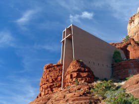
The Chapel of the Holy Cross appears to grow straight out of the red rock, a striking modernist sanctuary built into a butte high above the byway and completed in 1956. It was inspired by sculptor Marguerite Brunswig Staude, who envisioned a church that fused faith with the surrounding stone, and its soaring cross-shaped facade earned architectural acclaim soon after it opened. A short spur road off SR 179 climbs to the chapel, where the views back across red rock country are as moving as the building itself.
Details
Sedona
Frequently asked questions
When was the Red Rock Scenic Byway designated an All-American Road?
The Red Rock Scenic Byway, State Route 179, was designated an All-American Road by the Federal Highway Administration on September 22, 2005. It was the first road in Arizona to receive that honor, which is the highest designation in the national scenic byway system and recognizes routes considered a destination in their own right.
How long is the Red Rock Scenic Byway, and how long does it take to drive?
The scenic byway runs about seven and a half miles along State Route 179 between the Village of Oak Creek and Sedona. Driven straight through, it takes roughly fifteen to twenty minutes, but most visitors give it much longer to stop at pullouts, trailheads, and vista points along the way.
What are the must-see stops along the Red Rock Scenic Byway?
Traveling north, the highlights include Bell Rock and neighboring Courthouse Butte near the southern end, the dramatic spires of Cathedral Rock a bit farther on, and the Chapel of the Holy Cross set high on a red rock butte near Sedona. Numerous pullouts and trailheads along the route make it easy to pause for photos and short walks.
Is the Red Rock Scenic Byway free?
Driving the byway itself is free, since it is a public state highway. However, a Red Rock Pass is required to park at many trailheads and day-use areas along the route in the Coconino National Forest. A brief stop of a few minutes to take a photo at a scenic pullout generally does not require a pass, but leaving your vehicle parked at a trailhead to hike does.
What is the best time of day or year to drive the Red Rock Scenic Byway?
Early morning and the hour before sunset are magical, when low light sets the red rocks glowing at their deepest. Spring and fall bring the mildest weather and are especially popular, while summer days can be hot and busy. The scenery is beautiful year-round, so much of the choice comes down to when the light and the crowds suit you best.
Is the Red Rock Scenic Byway open year-round?
Yes. As a paved state highway at moderate elevation, State Route 179 stays open throughout the year. Occasional winter storms can bring brief snow or ice, so it is wise to check current road and weather conditions before setting out in the colder months.
Do you need four-wheel drive to drive the Red Rock Scenic Byway?
No. The Red Rock Scenic Byway is a paved, two-lane state highway, and any passenger car handles it easily. Four-wheel drive and high clearance are only needed for some of Sedona's off-highway red rock roads and pink-jeep trails, not for the byway itself.
What are the winter driving conditions on the Red Rock Scenic Byway?
The byway drives well through winter. Sedona sits at a moderate elevation with mild winters, and State Route 179 is paved and maintained, so snow is uncommon and usually clears quickly. If a storm does pass through, give the road time to be treated, and note that the higher Oak Creek Canyon route on State Route 89A from Flagstaff is more prone to ice and snow.
Can you see Cathedral Rock from the road?
Yes. Cathedral Rock stands about a mile west of the byway and is clearly visible from State Route 179, making it one of the easiest of Sedona's landmarks to spot from the car. To reach its trailhead, you turn off onto Back O' Beyond Road for a short drive to the parking area.
Why are the rocks along the byway so red?
The buttes are carved largely from the Schnebly Hill Formation, an ancient sandstone laid down hundreds of millions of years ago. Their vivid color comes from hematite, a form of iron oxide. An extremely thin coating of it stains the sand grains, and that trace of natural rust is enough to turn pale stone into deep, glowing red.
Nearby
Red Rock Scenic Byway
0.1 miles away
Red Rock Scenic Byway follows AZ-179 for about seven miles between the Village of Oak Creek and Sedona, threading past some of the most photographed red rock in the Southwest.

Bell Rock
2.5 miles away
Bell Rock is one of Sedona's most iconic butte formations, and one of the few where scrambling on the rock itself is allowed and common.

Cathedral Rock
3.6 miles away
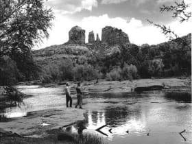
Cathedral Rock is the most-photographed rock formation in Arizona. The classic shot is from the Red Rock Crossing area of Oak Creek, with the twin spires reflected in the water.
Chapel of the Holy Cross
3.9 miles away
A modernist chapel built straight into the red rock buttes just south of Sedona, with a ninety-foot cross for a spine and a glass wall framing the Verde Valley.

Red Rock State Park
4.9 miles away
Red Rock State Park is a quieter alternative to Slide Rock, with guided creek hikes, ranger programs, and a riparian cottonwood corridor along Oak Creek.

Montezuma Well
8.6 miles away
Montezuma Well is a detached unit of Montezuma Castle NM - a 350-foot-diameter limestone sinkhole fed by a subsurface spring at 1.5 million gallons per day.
Boynton Canyon
11 miles away
Boynton Canyon is one of Sedona's premier day hikes - 6 miles round-trip through a lush canyon that ends in a box with high red walls. The Enchantment Resort sits midway through the canyon.
Slide Rock State Park
12 miles away
The main feature at Slide Rock State Park is a natural water slide worn smooth by Oak Creek flowing over sandstone slabs for centuries.

Montezuma Castle National Monument
12 miles away
Montezuma Castle is one of the best-preserved cliff dwellings in North America.
Oak Creek Canyon
14 miles away
Oak Creek Canyon runs from Sedona north to the Mogollon Rim, dropping 3,400 feet in 16 miles.
Oak Creek Canyon Overlook
14 miles away
The first overlook on US-89A heading south from Flagstaff into Oak Creek Canyon appears after the switchbacks at 6,400 feet and gives a full view into the canyon before the road descends.
Dead Horse Ranch State Park
15 miles away
A cool, green riverside state park on the Verde River just outside Cottonwood, with three fishing lagoons, shady cottonwood trails, and some of the best birding in Arizona.

Tuzigoot National Monument
15 miles away
Tuzigoot is a hilltop pueblo of 110 rooms occupied by the Sinagua people for nearly 300 years.

Fort Verde State Historic Park
15 miles away
Fort Verde preserves several original 1870s adobe buildings from an Apache Wars era army post, arranged around a parade ground you can cross in a few minutes.
Verde Canyon Railroad
18 miles away
Verde Canyon Railroad runs a 4-hour, 40-mile excursion through the Verde Canyon, which has no road access - train is the only way in.

Jerome
20 miles away
A former copper boomtown stacked up the side of a mountain, once branded the wickedest town in the West and now an artists' colony full of galleries and ghost stories.
Historic Route 66, Flagstaff to Winslow
45 miles away
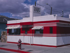
The Route 66 alignment east of Flagstaff passes through Winona (you need to know it) and ends at the famous Standin' on the Corner park in Winslow.