

Tuzigoot National Monument
25 Tuzigoot Rd, Clarkdale, AZ
Clarkdale, AZ
A whole stone village crowning a desert ridge above the Verde River, built room by room by the ancestral Sinagua more than six centuries ago.
Tuzigoot National Monument preserves a remarkable thing: an entire ancient village, a pueblo of stone rooms that once housed a community of the ancestral Sinagua people, crowning a limestone ridge above the Verde River. Built and expanded between roughly 1000 and 1400, it grew room by room until it climbed the whole crest of the hill, and a trail today lets visitors walk up through the ruins to the summit and its wide view over the valley.
The name Tuzigoot comes from an Apache phrase meaning crooked water, a reference to the winding Verde River below. The people who built and lived here, whom archaeologists call the Sinagua, farmed the river bottom, traded across the wider Southwest, and then left, part of the broad movement of ancestral Puebloan peoples across the region in the fifteenth century. Their descendants are counted among the Hopi and Yavapai-Apache communities of Arizona today.
What Travelers Love
- Walking up through the stone rooms of the pueblo to the ridge-top view
- The sweeping panorama over the Verde River valley and the mountains beyond
- The Tavasci Marsh below, alive with birds and wildlife
- The compact, walkable loop that packs a lot of history into a short visit
Worth Knowing
- The path to the top is short but climbs a hill and is exposed to the sun, so bring water and a hat
- This is an ancestral site sacred to living tribes; treat the walls and grounds with respect and stay on the trail
- Summer afternoons are hot; mornings and the cooler months are the best times to visit
- Pair it with nearby Montezuma Castle or the Verde Canyon Railroad for a fuller Verde Valley day
Learn about Tuzigoot National Monument
The Sinagua and their hilltop village
The builders of Tuzigoot were the Sinagua, an ancestral Puebloan culture named from Spanish words meaning without water, for the dry country they farmed. They settled the Verde Valley and raised a village on this ridge beginning around the year 1000, adding rooms over the centuries until the pueblo sprawled across the hilltop, many stories in places, entered through the roofs by ladder. At its height it held a substantial community that farmed the fertile river bottom below, growing corn, beans, squash, and cotton.
These people were part of a wide trading world. Archaeologists have found shell from the Pacific and Gulf coasts, macaw feathers from far to the south, and turquoise and pottery traded across the Southwest, evidence that the Verde Valley was no isolated backwater but a crossroads. By around 1400 the Sinagua had left Tuzigoot, part of the great regional migrations of the era, and their descendants live on today, connected to the Hopi and to the Yavapai-Apache Nation of the Verde Valley, who regard the site as an ancestral home.
Walking through the ruins
A short trail leads up through the pueblo, winding among the stone walls to the highest rooms at the summit. Unlike a cliff dwelling tucked into an alcove, Tuzigoot is an open hilltop village, so you can see how the rooms were stacked and joined, and one reconstructed room gives a sense of what the interiors were like, low and dim, with a roof hatch for light and access. From the top, the reward is a sweeping view over the Verde River, its marshes, and the mountains that ring the valley.
The stone from which the village was built came right from the ridge, and the walls have stood, and been stabilized, for centuries. A small museum at the base holds pottery, tools, jewelry, and other objects recovered when the site was excavated in the 1930s, offering an intimate look at the daily lives of the people who lived here, from their cooking and weaving to their trade goods and burials.
The marsh and the river
Below the pueblo lies Tavasci Marsh, a rare wetland fed by a spring on an old oxbow of the Verde River, and one of the richest wildlife spots in the region. The marsh and the river corridor draw a remarkable variety of birds, from herons and egrets to hawks and waterfowl, and an overlook lets visitors take in the wetland from above. It is easy to see why the Sinagua chose this spot, with the fertile bottomland and reliable water at their doorstep.
The Verde is one of Arizona's last free-flowing rivers, and the valley it carves is a green oasis in the high desert. Cottonwoods and willows line the banks, cool and shaded, and beaver, deer, javelina, and a wealth of birds make their home along the water. From the top of Tuzigoot the whole system spreads out below, the river, the marsh, the fields, and the mountains, a landscape that has drawn and sustained people for well over a thousand years.
Season by season
Fall and spring are the finest times to visit, with mild days perfect for the hilltop walk and the marsh full of migrating birds. Winter is cool and quiet, and the low sun throws long light across the ruins, though a cold snap can bring a dusting of snow to the surrounding peaks.
Summer is hot on the exposed ridge, so an early start and plenty of water are wise, but the monsoon storms that sweep in during the afternoons green the desert and swell the river. In any season, Tuzigoot's combination of ancient village, wide view, and living wetland makes it feel like a place where the deep past and the present landscape are laid out together in a single glance.
Closest Boutels
The closest Boutel™ stays, so you can turn this stop into an overnight. Each is a place we chose through independent editorial review, never a paid placement.
The Iron Horse Inn
Boutel1034 N Main St, Cottonwood, AZ 86326, Cottonwood, AZ
2 miles away|Learn More ›
Lantern Light Inn & Wedding Gardens
Boutel+3085 W State Rte 89A, Sedona, AZ
14 miles away|Learn More ›
Details
Clarkdale, AZ
Frequently asked questions
What is Tuzigoot National Monument?
Tuzigoot National Monument, near Clarkdale in Arizona's Verde Valley, preserves the ruins of a large ancestral Sinagua pueblo that crowns a hilltop overlooking the Verde River. Built and inhabited centuries ago, the sprawling stone village once contained dozens of rooms rising in tiers up the ridge, home to a thriving farming community. Today an easy loop trail winds through the well-preserved ruins to a rooftop overlook with sweeping valley views, and a visitor center displays artifacts, making Tuzigoot a fascinating window into the region's ancient past.
What can you see at Tuzigoot National Monument?
You can walk the short, mostly gentle loop trail through the hilltop pueblo ruins, seeing the stone rooms and walls of the ancient Sinagua village and climbing to a reconstructed rooftop room for panoramic views over the Verde River valley and surrounding mountains. The visitor center displays pottery, tools, and other artifacts that illuminate the lives of the people who lived here. The combination of well-preserved architecture, sweeping scenery, and cultural history makes for a rewarding and manageable visit suitable for most abilities.
Can you touch or climb on the ruins at Tuzigoot?
Visitors should stay on the designated trail and avoid climbing on or touching the fragile ancient walls, except where the monument specifically allows access, such as the reconstructed rooftop viewpoint, to help preserve these centuries-old structures that are also significant to descendant tribes. Removing artifacts or pottery shards is illegal. Admiring the ruins from the trail, taking photos, and learning from the interpretive signs and visitor center let you appreciate Tuzigoot while protecting it for future generations and respecting its cultural importance.
When is the best time to visit Tuzigoot National Monument?
Spring and fall offer the most comfortable temperatures for walking the exposed hilltop trail, while summer in the Verde Valley is hot, so early morning visits are best then, and winter is mild and pleasant. The site has little shade, so bring water and sun protection whenever you go. Mornings offer softer light and cooler air for the loop walk and views. The milder months make for the most enjoyable exploration of the ruins and valley vistas.
What is near Tuzigoot National Monument?
Tuzigoot is near Clarkdale and Cottonwood in the Verde Valley, close to the Verde Canyon Railroad, the historic mining town of Jerome on the hillside above, and Montezuma Castle's cliff dwelling to the south, with Sedona's red rocks a short drive away. Dead Horse Ranch State Park lies nearby along the river. That makes Tuzigoot an easy and enriching stop to combine with the Verde Valley's scenic railroad, ancient sites, and the nearby attractions of Jerome and Sedona.
Nearby
Dead Horse Ranch State Park
1.2 miles away
A cool, green riverside state park on the Verde River just outside Cottonwood, with three fishing lagoons, shady cottonwood trails, and some of the best birding in Arizona.
Verde Canyon Railroad
3.4 miles away
Verde Canyon Railroad runs a 4-hour, 40-mile excursion through the Verde Canyon, which has no road access - train is the only way in.

Jerome
5.1 miles away
A former copper boomtown stacked up the side of a mountain, once branded the wickedest town in the West and now an artists' colony full of galleries and ghost stories.

Jerome Grand Hotel
5.4 miles away
The Jerome Grand Hotel occupies the 1926 United Verde Hospital, built by the Phelps Dodge Corporation on the most prominent point in Jerome at 5,200 feet.
Mingus Mountain Viewpoint
7.9 miles away
Mingus Mountain rises on the north flank of the Black Hills above the Verde Valley and has a series of viewpoints accessible from US-89A on the switchbacking road between Prescott and Jerome.
Palatki Heritage Site, Sedona area
9.1 miles away
Palatki has two adjacent sites: a Sinagua cliff dwelling occupied 1150-1350 CE, and a shelter with 6,000 years of painted pictographs in overlapping layers.

Red Rock State Park
12 miles away
Red Rock State Park is a quieter alternative to Slide Rock, with guided creek hikes, ranger programs, and a riparian cottonwood corridor along Oak Creek.

Sycamore Canyon Wilderness
12 miles away
Sycamore Canyon is a 21-mile wilderness canyon with a perennial creek, sycamore-cottonwood gallery forest, and red rock walls.
Boynton Canyon
13 miles away
Boynton Canyon is one of Sedona's premier day hikes - 6 miles round-trip through a lush canyon that ends in a box with high red walls. The Enchantment Resort sits midway through the canyon.

Cathedral Rock
14 miles away
Cathedral Rock is the most-photographed rock formation in Arizona. The classic shot is from the Red Rock Crossing area of Oak Creek, with the twin spires reflected in the water.
Red Rock Scenic Byway
14 miles away
Red Rock Scenic Byway follows AZ-179 for about seven miles between the Village of Oak Creek and Sedona, threading past some of the most photographed red rock in the Southwest.

Bell Rock
15 miles away
Bell Rock is one of Sedona's most iconic butte formations, and one of the few where scrambling on the rock itself is allowed and common.
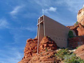
Chapel of the Holy Cross
15 miles away
A modernist chapel built straight into the red rock buttes just south of Sedona, with a ninety-foot cross for a spine and a glass wall framing the Verde Valley.

Montezuma Castle National Monument
16 miles away
Montezuma Castle is one of the best-preserved cliff dwellings in North America.

Montezuma Well
17 miles away
Montezuma Well is a detached unit of Montezuma Castle NM - a 350-foot-diameter limestone sinkhole fed by a subsurface spring at 1.5 million gallons per day.

Fort Verde State Historic Park
17 miles away
Fort Verde preserves several original 1870s adobe buildings from an Apache Wars era army post, arranged around a parade ground you can cross in a few minutes.
Slide Rock State Park
20 miles away
The main feature at Slide Rock State Park is a natural water slide worn smooth by Oak Creek flowing over sandstone slabs for centuries.