

Sycamore Canyon Wilderness
Sycamore Basin Trail, Clarkdale, AZ
Clarkdale, AZ
Sedona's red rock without Sedona's crowds, a wild roadless canyon where a lone stream carves color out of the plateau.
Sycamore Canyon is one of Arizona's great hidden red-rock canyons, a wild, roadless gorge just west of Sedona that rivals its famous neighbor in beauty while drawing only a fraction of the crowds. Carved into the same colorful rock that made Sedona famous, the canyon runs for many miles from the pine forests of the Colorado Plateau down into the Verde Valley, its walls glowing red and cream above a creek lined with the tall sycamore trees that give it its name.
What makes Sycamore Canyon special is precisely that it has been left wild. It is protected as a wilderness area, which means no roads, no development, and no easy shortcuts, so the only way in is on foot or horseback. That protection has kept it quiet and largely untouched, a place where you can walk for hours among red cliffs and cottonwood groves and meet almost no one, a rare thing in the busy country around Sedona.
What Travelers Love
- Red-rock canyon scenery to rival Sedona, but wild, quiet, and nearly empty
- A seasonal creek lined with big sycamores and cottonwoods deep in the desert
- The sense of true wilderness, roadless and remote, just a short drive from town
- Solitude and dark skies for those willing to hike in and earn the views
Worth Knowing
- There is no road into the canyon, so plan a real hike and carry all the water you will need
- The lower canyon is hot and exposed, so avoid it in summer and start early in the cooler seasons
- The creek runs only part of the year, so do not count on finding water and check conditions first
- This is remote backcountry with little to no cell service, so tell someone your route before you go
Learn about Sycamore Canyon Wilderness
A wilderness kept wild
Sycamore Canyon was set aside as one of Arizona's earliest wilderness areas, protected precisely so that it would stay roadless and undeveloped. Managed by the national forest, it forms a rugged corridor of red rock and desert stretching far into the backcountry, one of the largest such canyon wildernesses in the state. That designation is the reason the canyon feels so different from the developed country nearby.
The trade-off is that Sycamore asks something of its visitors. There are no facilities, no reliable water in dry stretches, and no vehicle access to speak of, so a visit means planning, effort, and self-reliance. But that effort is exactly what keeps the canyon pristine and quiet, and for many hikers the solitude of a wild red-rock canyon is worth every step it takes to reach it.
How the canyon was carved
Sycamore Creek and its ancestors cut this canyon down through layer after layer of rock at the southwestern edge of the Colorado Plateau. Near the top, the walls show pale limestone laid down under ancient seas, while lower down the canyon exposes the brilliant reds of old sandstone, the same formations that give Sedona its color. Over vast stretches of time, water and weather have carved the whole gorge and left cliffs, spires, and side canyons throughout.
The creek that did much of this work runs strongly with snowmelt and rain in the wetter months and shrinks to scattered pools or dry bed in the heat of summer. Where the water lingers, it supports pockets of lush green, and where it has cut deepest, it opens grand views of banded rock. The canyon is a textbook of the plateau's geology, written in stone and best read on foot.
A green corridor of life
For all its rugged dryness, Sycamore Canyon is a ribbon of life. The big Arizona sycamores, along with cottonwoods, willows, and ash, shade the creek bottom and blaze gold in autumn, and the year-round and seasonal water draws a surprising abundance of wildlife into this desert setting. The contrast of green riparian growth against red canyon walls is one of the canyon's signature sights.
Deer, javelina, and coyotes move through the canyon, black bear and mountain lion range the wilder reaches, and the streamside trees ring with birdsong in the cool of the day. Raptors nest on the cliffs, and the creek's pools shelter fish, frogs, and other water life. It is the kind of place where patience and quiet are rewarded, since much of the canyon's wildlife keeps to the margins of the day.
Season by season
Spring and fall are the best seasons in Sycamore Canyon. Spring brings running water, blooming desert plants, and comfortable temperatures for the exposed lower canyon, while fall lights the sycamores and cottonwoods gold and offers crisp, clear hiking weather. These shoulder seasons are when the canyon shows its best.
Summer is hot and largely waterless in the lower canyon, which makes long hikes there risky, though the higher, forested reaches near the rim stay cooler. Winter is cold, especially up on the plateau, and can bring snow to the higher country, but mild winter days in the lower canyon can be pleasant for a hike into the red rock in near-total solitude.
Closest Boutels
The closest Boutel™ stays, so you can turn this stop into an overnight. Each is a place we chose through independent editorial review, never a paid placement.
The Iron Horse Inn
Boutel1034 N Main St, Cottonwood, AZ 86326, Cottonwood, AZ
13 miles away|Learn More ›
Lantern Light Inn & Wedding Gardens
Boutel+3085 W State Rte 89A, Sedona, AZ
16 miles away|Learn More ›
Details
Clarkdale, AZ
Frequently asked questions
What is Sycamore Canyon Wilderness?
Sycamore Canyon Wilderness protects a vast, rugged red-rock canyon in central Arizona, often considered the second-largest canyon in the state after the Grand Canyon. Carved into the Colorado Plateau's edge between the Sedona, Williams, and Verde Valley areas, it features dramatic red-and-buff cliffs, a seasonal creek, pinyon-juniper and pine forest, and deep solitude. Far less visited and undeveloped compared to nearby Sedona, this wild canyon offers remote hiking, striking scenery reminiscent of Sedona's red rocks, and a true wilderness experience for those seeking backcountry adventure away from the crowds.
What can you do at Sycamore Canyon Wilderness?
You can hike rugged trails into the red-rock canyon from various access points on its rim and floor, enjoy dramatic scenery, backpack into the backcountry, and experience genuine solitude and wilderness far from developed areas. The canyon offers striking red-rock beauty similar to Sedona but with few people. Because it is undeveloped wilderness, there are no facilities, and trails can be remote and demanding. For experienced, well-prepared hikers and backpackers seeking spectacular scenery and quiet, Sycamore Canyon rewards the effort with a wild and beautiful escape.
What safety precautions should I take at Sycamore Canyon Wilderness?
This is remote, undeveloped wilderness with no services, unreliable water, limited cell coverage, and rugged, sometimes hard-to-follow trails, so come fully prepared: carry ample water and supplies, a map and navigation tools, and sun protection, and tell someone your plans. Avoid the intense heat of summer in the lower canyon, watch for wildlife, and know your route and limits. Access roads can be rough. Being self-sufficient and cautious is essential, since help is far away. Thorough preparation lets you safely enjoy this beautiful but demanding backcountry canyon.
When is the best time to visit Sycamore Canyon Wilderness?
Spring and fall offer the most comfortable temperatures for hiking the canyon, while summer can be very hot in the lower elevations, so early starts and ample water are essential then, and winter can bring cold and snow at higher points. Spring brings greenery and flowing water in the creek, and fall adds color. Because it is remote wilderness, plan supplies and check conditions in any season. For safe, comfortable exploration of this rugged red-rock canyon, the mild shoulder seasons of spring and fall are ideal.
What is near Sycamore Canyon Wilderness?
The wilderness lies in central Arizona between the red-rock country of Sedona and Oak Creek Canyon to the east, the Verde Valley with Cottonwood and Clarkdale to the south, and the Williams and Flagstaff areas to the north. Its scenery echoes nearby Sedona but with far more solitude. That makes Sycamore Canyon Wilderness a wild, scenic destination for prepared hikers to combine with the more accessible attractions of Sedona, the Verde Valley, and the Flagstaff region of central and northern Arizona.
Nearby
Palatki Heritage Site, Sedona area
4.2 miles away
Palatki has two adjacent sites: a Sinagua cliff dwelling occupied 1150-1350 CE, and a shelter with 6,000 years of painted pictographs in overlapping layers.

Tuzigoot National Monument
12 miles away
Tuzigoot is a hilltop pueblo of 110 rooms occupied by the Sinagua people for nearly 300 years.
Boynton Canyon
12 miles away
Boynton Canyon is one of Sedona's premier day hikes - 6 miles round-trip through a lush canyon that ends in a box with high red walls. The Enchantment Resort sits midway through the canyon.

Jerome
13 miles away
A former copper boomtown stacked up the side of a mountain, once branded the wickedest town in the West and now an artists' colony full of galleries and ghost stories.

Jerome Grand Hotel
13 miles away
The Jerome Grand Hotel occupies the 1926 United Verde Hospital, built by the Phelps Dodge Corporation on the most prominent point in Jerome at 5,200 feet.
Dead Horse Ranch State Park
13 miles away
A cool, green riverside state park on the Verde River just outside Cottonwood, with three fishing lagoons, shady cottonwood trails, and some of the best birding in Arizona.
Verde Canyon Railroad
14 miles away
Verde Canyon Railroad runs a 4-hour, 40-mile excursion through the Verde Canyon, which has no road access - train is the only way in.

Red Rock State Park
16 miles away
Red Rock State Park is a quieter alternative to Slide Rock, with guided creek hikes, ranger programs, and a riparian cottonwood corridor along Oak Creek.
Mingus Mountain Viewpoint
18 miles away
Mingus Mountain rises on the north flank of the Black Hills above the Verde Valley and has a series of viewpoints accessible from US-89A on the switchbacking road between Prescott and Jerome.

Cathedral Rock
18 miles away
Cathedral Rock is the most-photographed rock formation in Arizona. The classic shot is from the Red Rock Crossing area of Oak Creek, with the twin spires reflected in the water.
Slide Rock State Park
19 miles away
The main feature at Slide Rock State Park is a natural water slide worn smooth by Oak Creek flowing over sandstone slabs for centuries.
Red Rock Scenic Byway
19 miles away
Red Rock Scenic Byway follows AZ-179 for about seven miles between the Village of Oak Creek and Sedona, threading past some of the most photographed red rock in the Southwest.
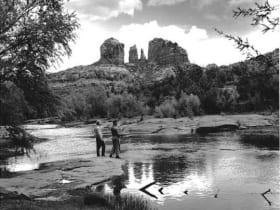
Oak Creek Canyon
19 miles away
Oak Creek Canyon runs from Sedona north to the Mogollon Rim, dropping 3,400 feet in 16 miles.
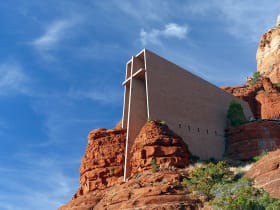
Chapel of the Holy Cross
19 miles away
A modernist chapel built straight into the red rock buttes just south of Sedona, with a ninety-foot cross for a spine and a glass wall framing the Verde Valley.
Oak Creek Canyon Overlook
20 miles away
The first overlook on US-89A heading south from Flagstaff into Oak Creek Canyon appears after the switchbacks at 6,400 feet and gives a full view into the canyon before the road descends.