

Historic Route 66, Flagstaff to Winslow
Arizona
Route 66, Arizona
Some roads carry you somewhere. Historic Route 66 between Flagstaff and Winslow carries you back in time. This is a stretch of the most famous highway in America, the old two-lane that once ran unbroken from Chicago to the Pacific and that people the world over still call the Mother Road. East of Flagstaff it slips down out of the tall pines and onto a wide, sunbaked plain, running beside and sometimes underneath modern Interstate 40, past faded trading posts and quiet ghost towns that the interstate left behind.
It is not a road of grand canyons or towering rock. Its magic is nostalgia, the pull of a highway that shaped how America travels. This is the same route the Joad family took west in John Steinbeck's The Grapes of Wrath, the road he called the mother road, the road of flight. Rolling it today, past the giant leaning arrows and the crumbling stone of Two Guns, you feel the ghosts of every family that ever chased a better life along this pavement, all the way to the corner in Winslow that a song made famous.
Learn about Historic Route 66, Flagstaff to Winslow
The Road
The drive runs roughly fifty-eight miles from Flagstaff east to Winslow, following the historic Route 66 corridor across the high desert of northern Arizona. Flagstaff sits high, around 7,000 feet, in a forest of ponderosa pine, so the road begins in cool mountain country and then descends gradually onto an open, treeless plain that stretches toward the horizon. The whole route sits at a moderate elevation, high enough for four real seasons but never truly alpine.
Much of the original 1926 alignment has been swallowed by Interstate 40, which now carries the through traffic. What survives is a patchwork. In places the old road runs as a marked business route or a paved frontage road right beside the interstate. In other places it fades to gravel or to abandoned, broken pavement that is best admired from a safe distance rather than driven. The most practical way to trace this stretch today is to follow I-40 and pull off at the historic exits, using the old road where it is paved and open and never forcing a passenger car onto a washed-out or closed section.
The driving experience is wide open and quiet. Between Flagstaff and Winslow the land empties out into rangeland and scrub, with long, lonesome miles where the only company is a freight train running the parallel rail line and a big western sky overhead. This is a drive for slowing down and reading the roadside, watching for the faded neon, the leaning signs, and the stone ruins that mark where a busy little highway town once stood.
How to Get There
Coming from the west, start in Flagstaff. From downtown you can pick up the old road where Route 66 still runs as a city street, then head east and join Interstate 40 at the edge of town. The classic way to begin the historic stretch is to take I-40 east to Exit 195, where the old alignment peels off through the small community of Winona before rejoining the corridor. From there the route runs east across the plain toward Winslow, about fifty-eight miles in all.
Coming from the east or from Phoenix, aim for Winslow and drive the route in reverse. From Phoenix, take Interstate 17 north to Flagstaff and then follow I-40 east, or from the Winslow side simply start downtown at the Standin' on the Corner park and work your way back west toward Flagstaff. Either direction is a fine way to see it.
Flagstaff and Winslow are the two anchor towns, with fuel, food, and lodging at each end. In between, the exits at Two Guns, Twin Arrows, and Meteor Crater are the main places to leave the interstate and touch the history, so plan your stops around them.
History
U.S. Route 66 was established on November 11, 1926, as one of the original numbered federal highways, stitching together a patchwork of older local roads into a single route running about 2,400 miles from Chicago to Santa Monica, California. Through northern Arizona it followed the same corridor the railroad had blazed decades earlier, and the stretch between Flagstaff and Winslow quickly became a lifeline. Trading posts, gas stations, motor courts, and diners sprang up along it to serve a rising tide of travelers crossing the desert by automobile.
In the 1930s the road took on a deeper meaning. Tens of thousands of families fleeing the Dust Bowl loaded their cars and drove west along Route 66 in search of work in California, and John Steinbeck immortalized their journey in The Grapes of Wrath in 1939. It was Steinbeck who gave the highway its most enduring nickname, the mother road. For a generation of Americans, this pavement was the road of escape, of hope, and of hardship, and the little towns along the Flagstaff to Winslow run watched a whole nation pass through.
The road's heyday lasted into the postwar years, when family vacations and open-road freedom made Route 66 a symbol of American travel. That golden age ended when the modern interstate system arrived. Beginning in the 1950s and continuing for decades, faster, wider freeways were built to replace the old two-lanes, and stretch by stretch Route 66 was bypassed. The final blow came on June 27, 1985, when Route 66 was officially decommissioned as a U.S. highway and removed from the federal system. Overnight the towns that lived off its traffic, places like Two Guns and Twin Arrows, were left stranded beside the new interstate, and many faded into ruin.
Almost as soon as it was gone, people began to miss it. A nostalgia movement grew through the late 1980s and 1990s to preserve and celebrate what remained, and much of the surviving road, including parts of this Arizona stretch, has since been recognized as a Historic Route. Today the old alignment is protected and promoted as a piece of American heritage, a living museum of neon, roadside ruins, and small-town Americana that travelers come from all over the world to drive.
Little-Known Facts
- U.S. Route 66 was established on November 11, 1926, making it one of the original numbered federal highways in the entire country.
- The nickname the mother road comes straight from John Steinbeck's 1939 novel The Grapes of Wrath, which followed the Joad family west along Route 66 during the Dust Bowl.
- The Route 66 anthem '(Get Your Kicks on) Route 66' name-checks Winslow, Arizona, and the little community of Winona east of Flagstaff sits right on this drive, the 'don't forget Winona' of the song.
- Route 66 was officially decommissioned as a U.S. highway on June 27, 1985, which stranded the trading-post towns along this stretch beside the new Interstate 40 and left many of them to become ghost towns.
- Twin Arrows got its name from two enormous arrows, telephone poles fitted with feathers and tips, planted nose-down in the ground beside the highway to draw drivers into the trading post.
- Two Guns sits at the edge of Canyon Diablo and has a dark, layered history, from a violent frontier trading post to a Route 66 roadside zoo, and its stone ruins still stand beside the old road.
- The Standin' on the Corner park in Winslow was inspired not by a Route 66 song but by the Eagles' 1972 hit 'Take It Easy,' which mentions standing on a corner in Winslow, Arizona.
- La Posada in Winslow opened in 1930 as one of the grand Fred Harvey railroad hotels, designed by architect Mary Colter, and after nearly being demolished it was rescued and restored into one of the finest historic hotels on all of Route 66.
Along the Route
Historic Downtown Flagstaff
The drive begins in Flagstaff, where Route 66 still runs right through the heart of town as a lively downtown street lined with historic brick buildings, old railroad depots, and vintage signs. Trains rumble through on the parallel tracks just as they have for more than a century. It is the perfect place to fuel up, grab a meal, and soak in a bit of Mother Road atmosphere before heading east onto the open plain.
Walnut Canyon National Monument
A short detour just south of the route near Flagstaff reaches Walnut Canyon, where ancient cliff dwellings are tucked into the ledges of a deep limestone gorge. The Sinagua people built these small stone homes into the canyon walls around 900 years ago, and a trail loops past many of them. It is an easy add-on early in the drive and a striking change from the flat country ahead.
Winona
Winona is a small spot east of Flagstaff best known for one line in the Route 66 song, the famous 'don't forget Winona.' An old steel truss bridge from the original road alignment still stands here, a quiet marker of where the highway once crossed. There is little town left, but the name alone earns it a slow drive-by.
Two Guns
Two Guns is a genuine Route 66 ghost town at the rim of Canyon Diablo, where the stone ruins of a 1920s trading post, gas station, and old roadside zoo still stand beside the historic road. Its story runs dark and deep, from a bloody frontier past to its glory days luring tourists off the highway. Today it sits weathered and empty, one of the most atmospheric stops on the drive. Explore respectfully and mind the crumbling structures and the canyon edge.
Twin Arrows
Twin Arrows is an abandoned Route 66 trading post famous for the two giant arrows planted nose-down in the ground out front, built from telephone poles fitted with feathers and tips to catch a driver's eye. The old buildings are faded and closed, but the leaning arrows remain a beloved photo stop and one of the most recognizable pieces of roadside Americana on the whole route.
Meteor Crater
Just south of the route, a paved road leads to Meteor Crater, a vast bowl nearly three-quarters of a mile wide blasted out of the desert by a meteorite that struck about 50,000 years ago. Rim viewpoints and a visitor center let you take in the sheer scale of the impact. It is the most dramatic natural sight along the drive and an easy detour off the highway.
La Posada Hotel
In Winslow, La Posada opened in 1930 as one of the last and grandest of the Fred Harvey railroad hotels, designed by architect Mary Colter to feel like a rambling old Spanish hacienda. Saved from demolition and beautifully restored, it now anchors the east end of the drive with gardens, tilework, and railroad history. It is a fitting grand finale after miles of open plain.
Standin' on the Corner Park
The corner in downtown Winslow made famous by the Eagles' 1972 hit 'Take It Easy' marks the east end of the drive, complete with a life-size statue, a trompe-l'oeil mural, and the flatbed Ford from the lyric parked at the curb. It is one of the most photographed corners in Arizona and a cheerful, only-on-Route-66 way to cap the journey.
Details
Flagstaff to Winslow
Frequently asked questions
Is Historic Route 66 between Flagstaff and Winslow a designated scenic drive?
This stretch is part of the original U.S. Route 66, established on November 11, 1926, and often called the Mother Road. Route 66 was decommissioned as a U.S. highway on June 27, 1985, but much of the surviving road, including parts of this Arizona corridor, has since been protected and promoted as a Historic Route and a piece of American heritage. It is a historic road rather than a formal All-American Road or National Scenic Byway.
How long is the Flagstaff to Winslow drive, and how long does it take?
The route runs roughly fifty-eight miles from Flagstaff east to Winslow along the Route 66 corridor. Driven straight through on Interstate 40 it takes under an hour, but this is a drive meant for stopping. Give yourself half a day or more to pull off at Two Guns, Twin Arrows, Meteor Crater, and Winslow and to soak in the roadside history.
What are the must-see stops between Flagstaff and Winslow?
Heading east, the highlights are historic downtown Flagstaff where Route 66 is still the main street, the cliff dwellings of nearby Walnut Canyon, the ghost town ruins of Two Guns, the leaning giant arrows at Twin Arrows, the vast bowl of Meteor Crater just off the route, and finally Winslow itself with the restored La Posada Hotel and the Standin' on the Corner park.
Is the drive free, or do I need a pass or fee?
Driving Route 66 and Interstate 40 is free, since they are public highways. Some individual attractions along the way charge an entry fee, such as Meteor Crater and Walnut Canyon National Monument, and the Standin' on the Corner park and downtown Flagstaff are free to visit. Two Guns and Twin Arrows are open ruins with no formal admission.
What is the best time of day and season to drive Route 66 near Flagstaff?
Morning and late afternoon light is beautiful for photographing the old signs, ruins, and leaning arrows, and it keeps you out of the harshest midday sun on the open plain. Spring and fall bring the mildest weather. Summer days can be hot out on the flats, and winter can bring cold and occasional snow around Flagstaff, so many travelers favor the shoulder seasons.
Is Route 66 between Flagstaff and Winslow open year-round?
Yes. Interstate 40 and the paved Route 66 segments along this corridor stay open all year. Winter storms can briefly bring snow or ice, especially in the higher country around Flagstaff, so check current road and weather conditions before you set out in the colder months, but there is no seasonal closure of the route itself.
Do I need four-wheel drive or high clearance for this drive?
No, not for the main route. Interstate 40 and the paved Route 66 business and frontage segments are fine for any passenger car. Be aware that some pieces of the original old alignment have decayed into gravel or broken, abandoned pavement. Those unmaintained sections are best viewed from a safe spot rather than driven, and you should never take a passenger car onto a washed-out or closed stretch of the old road.
What are winter driving conditions like on this stretch?
The Flagstaff end sits high, around 7,000 feet, and can get real snow in winter, while the plain toward Winslow is lower and drier. Interstate 40 is well maintained and treated, but winter storms can bring snow, ice, and strong wind across the open country. If a storm is passing through, give the road time to be cleared and check conditions before driving.
Are there gas stations and services along the way, or long empty stretches?
Flagstaff and Winslow at either end have plenty of fuel, food, and lodging, but the fifty-eight miles between them run through wide-open, largely empty country with few services. Fill your tank before you leave town and carry water and snacks, since the ghost-town stops like Two Guns and Twin Arrows are ruins with nothing for sale.
Is there cell service along the drive?
Cell coverage is generally good in Flagstaff and Winslow and reasonable along Interstate 40, since the interstate is a major route. It can grow spotty out on the open plain and at the more remote ruins away from the freeway, so download maps ahead of time and do not count on a strong signal at every stop.
Nearby
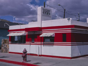
Historic Route 66, Flagstaff to Winslow
0.0 miles away
The Route 66 alignment east of Flagstaff passes through Winona (you need to know it) and ends at the famous Standin' on the Corner park in Winslow.

Meteor Crater
7.4 miles away
Meteor Crater (officially Canyon Diablo Crater) is a well-preserved impact crater 0.75 miles in diameter and 550 feet deep, formed by a nickel-iron meteorite about 50,000 years ago.
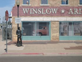
Standin' on the Corner Park
23 miles away
Standin' on the Corner Park in downtown Winslow has the mural (painted by John Pugh) and bronze statue of a man with a guitar hitchhiking - the scene described in Take It Easy by the Eagles.

La Posada Hotel
23 miles away
La Posada (1930, Spanish for "the resting place") was the last great Fred Harvey Company hotel on the Santa Fe line and Mary Colter's masterpiece.
Red Rock Scenic Byway
44 miles away
Red Rock Scenic Byway follows AZ-179 for about seven miles between the Village of Oak Creek and Sedona, threading past some of the most photographed red rock in the Southwest.