
Scituate Reservoir
Scituate Reservoir
Scituate, RI
The largest body of fresh water in Rhode Island, drinking supply for much of the state, made by damming a river and flooding a village whose foundations still lie beneath it.
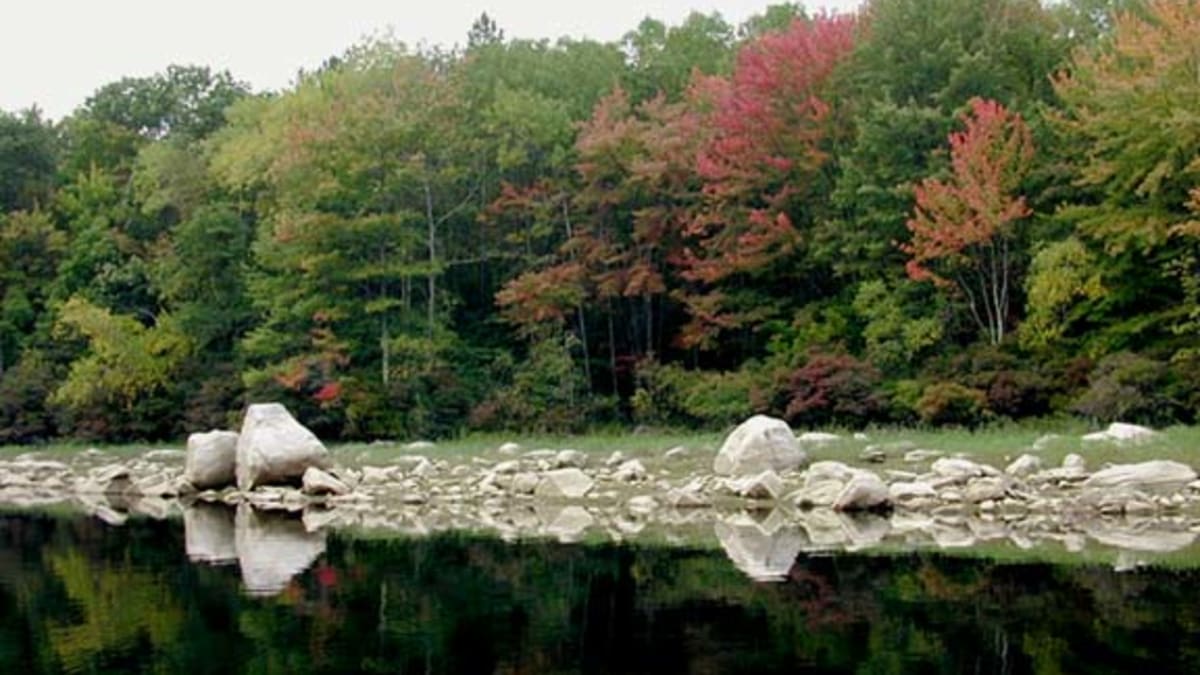
Scituate Reservoir is the largest inland body of water in Rhode Island, a broad, many-armed lake spread across the rural western hills. It is not a recreation lake but a working one: it holds the drinking water for the majority of the state's population, gathered from a protected watershed of forest and streams and sent east to Providence and its suburbs.
The reservoir is also a drowned place. To build it in the 1920s, engineers dammed the Pawtuxet River and deliberately flooded a working village and its farms, mills, homes, churches, and cemeteries, relocating the living and the dead to make way for the water. What looks like an ancient natural lake is in fact a century-old act of engineering, with a lost community lying beneath its calm surface.
What Travelers Love
- Sweeping views across a vast, glass-still lake ringed by protected forest
- The classic scene from the Route 12 causeway, with water on both sides
- A rural, uncommercial landscape that feels far from the coast most visitors know
- The quiet drama of a working waterscape that supplies most of the state
Worth Knowing
- This is a protected drinking-water supply: swimming, wading, boating, and body contact with the water are prohibited
- Enjoy it from the roads, causeways, and overlooks rather than the shoreline itself
- The surrounding watershed land is patrolled; respect posted access rules
- Autumn is the standout season, when the forested shores turn color around the water
Learn about Scituate Reservoir
The story of the reservoir
By the early twentieth century, the growing city of Providence had outgrown its water supply and needed a large, clean source. Engineers chose the valley of the north branch of the Pawtuxet River in Scituate, a rural area whose forested hills could gather and protect a great volume of water.
Building it meant erasing what was already there. The project required flooding the village of Ashland and other settlements in the valley, so the state acquired the land, and homes, farms, mills, shops, schools, and churches were torn down or moved. Even the dead were relocated, with cemeteries disinterred and graves reburied on higher ground before the waters rose.
The Kent Dam, later known as the Gainer Memorial Dam, closed off the valley in the 1920s, and the river slowly backed up to form the reservoir. When it filled, it became the largest lake in Rhode Island, a made landscape that quickly came to look permanent and natural.
Ever since, the reservoir and the thousands of acres of forest around it have been kept as a protected watershed. That protection is why the shoreline is undeveloped and off-limits, and it is also why the surrounding countryside has stayed so rural: much of the land is owned to keep the water clean rather than to build on.
How to experience it
Because contact with the water is forbidden, the reservoir is a place to see rather than to enter. The best experience is from the roads that cross and skirt it, especially the causeway on Route 12, where the water opens out on both sides and the far shore dissolves into forest.
Several roadside overlooks and pull-offs give long views across the arms of the lake, and the drive through the surrounding towns of Scituate and Foster is a scenic outing in itself, past stone walls, old farms, white-steepled villages, and second-growth woods.
The reward is stillness. On a calm morning the reservoir lies mirror-flat, reflecting the sky and the wooded hills, one of the most peaceful landscapes in a small and crowded state.
The watershed and its wildlife
The protected forest around the reservoir functions as a natural filter, and it doubles as a large block of undisturbed wildlife habitat in a region that is otherwise increasingly developed.
Bald eagles and osprey hunt the open water, herons and waterfowl work the coves, and the surrounding woods hold deer, wild turkey, fox, coyote, and a full range of New England forest birds. The very restrictions that keep people off the water leave the wildlife largely undisturbed.
The result is a rare thing in Rhode Island: a large, quiet, mostly wild landscape, kept that way not for recreation but to protect the water that most of the state drinks.
Season by season
Spring greens the watershed forest and swells the streams that feed the reservoir, and returning osprey and eagles become easier to spot over the water.
Summer is lush and quiet, best appreciated in the early morning when the lake is still and the light is soft over the far shore.
Fall is the reservoir's finest season, when the hardwood forest ringing the water turns gold, orange, and red, doubled in the reflection on a calm day.
Winter strips the landscape bare and can freeze the coves and edges, a stark, silent time when the scale of the reservoir and its wooded frame is most apparent.
Closest Boutels
The closest Boutel™ stays, so you can turn this stop into an overnight. Each is a place we chose through independent editorial review, never a paid placement.
Details
Scituate, RI
Frequently asked questions
What is the Scituate Reservoir?
The Scituate Reservoir, in western Rhode Island, is the largest body of fresh water in the state, a vast and beautiful reservoir that serves as the primary source of drinking water for much of Rhode Island. Set amid rolling wooded countryside, the reservoir is a scenic and tranquil sight, its waters reflecting the surrounding forest, especially lovely in autumn, and it is best appreciated from scenic roads, overlooks, and the surrounding area. Because it is a protected drinking-water supply, direct access to the water is limited to protect its purity. A serene and scenic landmark, it delights those who drive its shores. With its scenic waters, the Scituate Reservoir offers a lovely destination in Rhode Island.
Can you swim or boat at the Scituate Reservoir?
No, swimming, boating, and other water activities are not permitted at the Scituate Reservoir because it is the protected primary source of drinking water for much of Rhode Island, and keeping the water clean and safe means keeping people and activities out of and off the water. Visitors instead enjoy the reservoir's beauty from scenic roads, overlooks, and the surrounding countryside, respecting the restrictions that protect this vital resource. Appreciating it from the shore and respecting the rules ensure the reservoir stays pure for everyone in Rhode Island.
What can you do around the Scituate Reservoir?
You can enjoy the reservoir's scenic beauty by driving the roads that skirt its shores, stopping at overlooks, photographing the tranquil water and surrounding forest, and exploring the charming rural villages and countryside nearby, all while respecting the restrictions that keep the drinking water protected. The scenic drives, the beautiful views, the autumn foliage reflected in the water, and the peaceful rural setting are the draws, making it a lovely area to explore by car. Its serene beauty is the appeal. With its scenery, the Scituate Reservoir offers a rewarding experience in Rhode Island.
When is the best time to visit the Scituate Reservoir?
The reservoir is beautiful year-round, but autumn is especially glorious, when the surrounding forests turn brilliant colors reflected in the water, making the scenic drives and overlooks spectacular, while spring and summer offer lush green surroundings. For the most beautiful scenery, aim for the fall foliage season, or enjoy the green of spring and summer, at the Scituate Reservoir in Rhode Island.
What is near the Scituate Reservoir?
The Scituate Reservoir is in western Rhode Island, within reach of the North Scituate Village Green, the rural villages and countryside of western Rhode Island such as Foster with its covered bridge, and the routes toward Providence to the east. That makes the Scituate Reservoir a lovely stop to combine with the North Scituate Village Green and the other attractions of rural western Rhode Island on a visit to the state.
Nearby
North Scituate Village Green
3.3 miles away
A pretty New England village green that turns into a giant fair once a year.

Clemence-Irons House
5.4 miles away
This is architecture you cannot see almost anywhere else in America.
Paine House Museum
6.9 miles away
A small, friendly history museum where old-time daily life feels real.
Nathanael Greene Homestead
7.5 miles away
Plenty of people know Nathanael Greene from a statue or a county named for him, but few realize his actual house survives, quietly, in western Rhode Island.

Swamp Meadow Covered Bridge
8.1 miles away
Rhode Island is not covered-bridge country, which is exactly why this one is a find.

Roger Williams Park
9.7 miles away
This is Providences great green lung, a 435-acre Victorian park laid out in the 1870s in the sweeping pastoral style of the era.

Roger Williams Park Zoo
9.8 miles away
This is the classic family day out in Providence. The Roger Williams Park Zoo, founded in 1872 and one of the oldest in the country, packs elephants, giraffes, zebras, red pandas, and snow leopards in...

Rhode Island State House
10 miles away
People photograph its dome from the highway without realizing they can walk right in.

RISD Museum
11 miles away
Visitors to Providence often walk right past it, but the RISD Museum on Benefit Street rivals museums in far bigger cities.
The Providence Athenaeum
11 miles away
Step off Benefit Street into the Providence Athenaeum and you step into 1838.
Benefit Street, the Mile of History
11 miles away
Architecture lovers make pilgrimages here, but many visitors never climb the hill to see it.
Hearthside House
12 miles away
A stone mansion with a jilted-lover legend, hiding on an old country road most travelers never find.

Crescent Park Looff Carousel
13 miles away
This is a genuine piece of amusement-park history kids can actually ride.

Lincoln Woods State Park
13 miles away
This is the green lung just north of Providence, a rocky, wooded park of oak and glacial boulders wrapped around Olney Pond.
Slater Mill
13 miles away
This is the actual birthplace of the American factory, and it is easy to walk past without grasping the weight of it.

Slater Park Looff Carousel
14 miles away
Most people driving past Slater Park have no idea one of the great early carousels in the country is turning inside it.

Slater Memorial Park
14 miles away
An easy family park with a hundred things to do and room to run.
Museum of Work and Culture
15 miles away
A history museum that works because you walk right through it.
Rocky Point State Park
15 miles away
Rocky Point is a shoreline haunted, in the fondest way, by a lost amusement park.
East Bay Bike Path
16 miles away
This is the family bike ride in the East Bay. The East Bay Bike Path is a flat, paved rail-trail running 14 miles from Providence to Bristol, mostly away from cars, so young riders can pedal without t...
Smiths Castle
16 miles away
People drive right past this on Post Road without realizing they are passing one of the oldest houses in America.

Historic Wickford Village
17 miles away
Wickford is the kind of place people stumble into and cannot believe is not more famous.
Diamond Hill Park
18 miles away
For a quick leg-stretch with a view, pull off at Diamond Hill Park at 4097 Diamond Hill Rd in Cumberland.
Colt State Park
18 miles away
This former gentlemans farm gives Bristol a broad, open front on Narragansett Bay.

Blithewold Mansion, Gardens and Arboretum
19 miles away
Garden people travel for this one; casual visitors are stunned to find giant sequoias on the Rhode Island shore.

Herreshoff Marine Museum
19 miles away
Sailors know it, but plenty of visitors miss that a tiny Bristol yard once ruled world yacht racing.
Linden Place
19 miles away
It looks like a simple grand house on the parade route, but Linden Place at 500 Hope St carries a heavier story.