

Camelback Mountain
5651 N Echo Canyon Cir, Phoenix, AZ
Phoenix, AZ
A red desert mountain shaped like a kneeling camel rising straight out of the city, its two steep trails a rite of passage for Phoenix hikers.
Camelback Mountain is the signature landmark of the Phoenix valley, a great hump of red and tan rock rising abruptly out of the surrounding city. Seen from a distance, its profile really does suggest a camel kneeling on the desert floor, with a head, a hump, and a saddle between. It is impossible to miss and, for the many who climb it, impossible to forget.
The mountain is beloved above all as a hiking challenge. Two steep trails lead to its summit, both demanding real effort and some hand-over-hand scrambling, and reaching the top is a rite of passage for Phoenix residents and a bucket-list climb for visitors. The reward is a panoramic view over the entire Valley of the Sun, city and desert spread out below. It is a rare thing to find a genuine mountain adventure in the middle of a major metropolis.
What Travelers Love
- A demanding summit climb right in the middle of a major city
- Sweeping views over the whole Valley of the Sun from the top
- The mountain's distinctive camel shape and red rock formations
- The sense of accomplishment that comes with reaching the summit
Worth Knowing
- Both summit trails are steep and strenuous, with rock scrambling and no easy way up
- Summer heat is dangerous here, so hike very early or in the cooler months and carry ample water
- The trailhead lots fill fast, so arrive early or expect to wait for parking
- This is a hard hike, not a stroll, so know your limits and turn back if you must
Learn about Camelback Mountain
The shape of a camel
Camelback gets its name and its fame from its shape. From the right angle, the mountain resembles a camel resting on its knees, with a rounded hump to the east and a lower head and neck to the west, joined by a saddle. The two ends are made of different rock: the head is red sandstone, sculpted into cliffs and hollows, while the hump is older granite, giving the mountain a two-part character.
That distinctive silhouette has made Camelback the defining landmark of the Phoenix skyline, a natural compass point recognized by everyone in the valley. The red sandstone of the head, weathered into caves and rounded forms, is especially striking, glowing warm in the low light of morning and evening above the surrounding neighborhoods.
Two trails to the top
Two summit trails climb Camelback, and neither is easy. The Echo Canyon trail, on the north side, is short but brutally steep, gaining elevation fast over bare rock, with sections where handrails and scrambling are needed to haul yourself up. The Cholla trail, approaching from the east along the mountain's ridge, is a bit longer and starts more gently before turning to steep rock near the top.
Both trails demand fitness, sure footing, and care, and both funnel hikers onto rocky scrambles where hands are as useful as feet. There is no gentle way up Camelback, which is part of its appeal to those who climb it. The mountain sees enormous numbers of hikers, and rangers and rescuers stay busy, so honest self-assessment matters. But for those prepared for the effort, the climb is exhilarating.
The view from the summit
The payoff for the hard climb is a truly panoramic summit view. From the top of Camelback, the entire Valley of the Sun spreads out in every direction, the vast grid of Phoenix and its neighbors, the ribbons of freeway, and the surrounding desert mountains rising beyond the city's edge. Downtown Phoenix, Scottsdale, and the distant ranges all lay themselves out below.
It is a view that captures the strange character of the place, a huge modern city set in raw Sonoran Desert, ringed by mountains and washed in intense light. At sunrise the valley glows soft and pink, and at sunset the desert peaks turn gold. Standing on the summit, catching your breath after the climb, you get the whole sweep of it at once.
A mountain in the city
Camelback's greatest oddity is its setting. This is a genuine desert mountain, complete with steep trails, cliffs, cactus, and wildlife, entirely surrounded by one of the largest cities in the country. Upscale neighborhoods and resorts climb its lower slopes, yet the peak itself remains wild and rugged, a preserved island of desert in the urban sea.
That accessibility is a large part of why the mountain is so beloved and so busy. Residents can leave home and be scrambling up a real mountain within minutes, and visitors staying at the valley's resorts find a serious hike on their doorstep. Camelback embodies the particular appeal of Phoenix, a city where the desert wilderness is never far away and, in this case, rises right up in its midst.
Closest Boutels
The closest Boutel™ stays, so you can turn this stop into an overnight. Each is a place we chose through independent editorial review, never a paid placement.
Details
Phoenix, AZ
Frequently asked questions
What is Camelback Mountain?
Camelback Mountain is an iconic desert peak rising dramatically in the heart of the Phoenix metropolitan area, named for its resemblance to a resting camel. A beloved landmark straddling Phoenix and Scottsdale, it offers two challenging summit trails that reward hikers with sweeping panoramic views of the Valley of the Sun. Its distinctive red-rock and granite slopes make it one of the most recognizable and popular hiking destinations in Arizona, drawing fitness enthusiasts and view-seekers, though its trails are far more strenuous than many visitors expect.
How hard are the Camelback Mountain hiking trails?
Both summit routes, Echo Canyon and Cholla, are strenuous and demanding, involving steep climbs, rocky scrambling over boulders, and sections requiring the use of your hands, so they are rated difficult and are not suitable for casual or unprepared hikers. The round trip gains significant elevation over relatively short but tough distances. Good fitness, sturdy footwear, and caution are essential. Many people underestimate the difficulty, so honestly assessing your ability before attempting the summit is important for a safe hike.
What safety precautions should I take on Camelback Mountain?
This is critical: the trails are steep, rocky, and fully exposed to the sun, and the desert heat is dangerous, causing frequent rescues and even deaths, so never hike in the heat of the day in warm months. Start early, carry far more water than you think you need, wear proper footwear and sun protection, and turn back if you feel dizzy, exhausted, or overheated. Avoid the mountain entirely during extreme heat warnings. Know your limits, watch your footing on the scrambles, and hike with others when possible.
When is the best time to hike Camelback Mountain?
The cooler months from late fall through early spring offer the safest and most comfortable conditions, and even then, early morning starts are best to beat the heat and crowds and to find parking at the small trailhead lots. In the hot months, the mountain is dangerous during the day, and hiking should be limited to the early morning or avoided altogether during extreme heat. Sunrise hikes are popular and beautiful. Always check the forecast and avoid the trails in dangerous heat.
What is near Camelback Mountain?
Camelback Mountain sits between Phoenix and Scottsdale, near the resorts, dining, and shopping of both cities, with the Desert Botanical Garden, Papago Park, and Old Town Scottsdale within easy reach, and downtown Phoenix's museums a short drive away. That makes Camelback an iconic outdoor challenge to combine with the Valley of the Sun's many attractions, from gardens and museums to the vibrant dining and nightlife of Scottsdale, on a visit to the Phoenix area.
Nearby
Scottsdale Old Town
3.3 miles away
Scottsdale's Old Town has the highest concentration of Western art galleries in the United States.

Desert Botanical Garden
4.4 miles away
The Desert Botanical Garden in Papago Park has 50,000 plants representing 4,500 species from deserts worldwide, including one of the world's most comprehensive collections of Sonoran Desert plants.

Papago Park
4.4 miles away
Hole in the Rock is a natural opening in a red volcanic butte in Papago Park, a city park straddling the Phoenix-Scottsdale border.

Sonoran Desert
5.0 miles away
The Sonoran Desert covers 100,000 square miles of southwestern Arizona, southeastern California, and northwestern Mexico.
Roosevelt Row Arts District
6.5 miles away
Roosevelt Row (1st-3rd Streets, 1st-7th Avenues) is a 15-block district with over 100 painted murals, live-work artist studios, galleries, and some of Phoenix's best food and cocktail culture.

Heard Museum
6.5 miles away
The Heard Museum has the most comprehensive collection of Southwest Native American art and culture in the world.

Liberty Wildlife
8.0 miles away
One of the largest wildlife rehabilitation centers in the Southwest, in south Phoenix, heals thousands of injured desert animals a year and opens to the public, where rescued eagles, owls, hawks, and...
Taliesin West
9.6 miles away
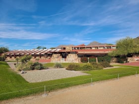
Taliesin West was Frank Lloyd Wright's winter home and architecture school from 1937 until his death in 1959. The campus is still an active school (Frank Lloyd Wright School of Architecture).
South Mountain Park
13 miles away
South Mountain Park and Preserve covers 16,000 acres at the southern edge of Phoenix, making it one of the largest municipal parks in the United States.

McDowell Sonoran Preserve
17 miles away
McDowell Sonoran Preserve is one of the largest urban preserves in the US, protecting a significant section of the McDowell Mountains and surrounding Sonoran Desert from development.

Apache Trail Scenic Drive
29 miles away
The Apache Trail (AZ-88) follows the route used to haul supplies during the Roosevelt Dam construction.