


McDowell Sonoran Preserve
27102-27002 N 128th St, Scottsdale, AZ
Scottsdale, AZ
A huge sweep of protected Sonoran Desert reaching right to the edge of the city, laced with trails that climb from saguaro flats into rugged mountains.
The McDowell Sonoran Preserve is one of the largest urban preserves in the country, a vast expanse of protected Sonoran Desert that Scottsdale set aside so that wild country would survive right at the city's doorstep. It stretches across tens of thousands of acres of desert flats, washes, and the rugged McDowell Mountains, threaded by a well-designed network of trails for hiking, mountain biking, and horseback riding.
What makes it remarkable is the contrast. One moment you are in a growing desert city, the next you are alone among towering saguaros with a coyote trotting off through the brush and nothing but mountains ahead. The preserve exists because residents chose to protect this land rather than pave it, and it stands as a model of a city keeping the desert that gives it its character.
What Travelers Love
- Miles of desert trails within minutes of the city
- Classic Sonoran scenery of saguaro, palo verde, and rocky peaks
- Well-built trailheads with maps, ramadas, and clear signage
- Sunrise and sunset light on the McDowell Mountains and cactus
Worth Knowing
- Summer heat is severe, so hike at dawn, carry ample water, and avoid the midday sun
- The desert has thorns, uneven rock, and wildlife, so wear sturdy shoes and stay on trails
- Popular trailheads fill up on cool-season weekends, so arrive early
- There is little shade out on the trails, so bring a hat, sunscreen, and more water than you think you need
Learn about McDowell Sonoran Preserve
A city that saved its desert
As Scottsdale and the wider Phoenix area grew rapidly, the open desert around them was vanishing under new development. In response, the community organized to protect a large block of that desert, voting to tax themselves to buy and preserve the land before it could be lost. The effort, driven by local citizens and stewards, grew the preserve into one of the largest of its kind in the nation.
That grassroots origin still shapes the place. Volunteer stewards help build and maintain the trails, lead hikes, and watch over the land, and the preserve is managed to stay as natural as possible rather than being turned into a manicured park. The result is genuine wild desert, kept intact right where the city ends, a legacy the community is rightly proud of.
The Sonoran Desert up close
The preserve protects a rich stretch of the Sonoran Desert, the lushest desert in North America. Giant saguaro cactus stand like sentinels across the slopes, alongside cholla, prickly pear, ocotillo, and the green-barked palo verde and mesquite that shade the washes. In spring, after a wet winter, wildflowers and cactus blooms can wash the desert in color.
This habitat teems with life for those who look. Coyotes, javelinas, jackrabbits, and desert cottontails move through the brush, while roadrunners dash across the trails and hawks circle overhead. Lizards sun on the rocks, and in the cooler hours the desert comes alive with birdsong. Early morning and evening are the best times both for wildlife and for escaping the heat.
The McDowell Mountains and its trails
Rising behind the desert flats are the McDowell Mountains, a rugged range of granite peaks and boulder-strewn slopes that give the preserve its dramatic backdrop. Trails climb from the easy flats up into these mountains, offering everything from gentle desert strolls to steep, rocky ascents that reward hikers with sweeping views across the Valley of the Sun.
The trail network is one of the preserve's great assets, extensive, well-signed, and served by proper trailheads with maps, shade ramadas, and restrooms. Hikers, trail runners, mountain bikers, and equestrians all share the paths, and there is something here for every level, from a short after-work loop to a long day out among the peaks.
Seasons and desert light
The preserve is a year-round destination, but the seasons demand respect. From fall through spring the weather is glorious, with warm days and cool mornings perfect for long hikes, and the spring bloom can be spectacular after a rainy winter. This is peak season, and popular trailheads fill early on weekends.
Summer is a different world, with dangerous heat that makes any hiking a dawn-only affair with plenty of water, and midday best spent indoors. In every season the finest hours are the edges of the day, when the low sun turns the saguaros to silhouettes and the McDowells glow warm against the sky, a reminder of why this desert was worth saving.
Closest Boutels
The closest Boutel™ stays, so you can turn this stop into an overnight. Each is a place we chose through independent editorial review, never a paid placement.
Details
Scottsdale, AZ
Frequently asked questions
What is the McDowell Sonoran Preserve?
The McDowell Sonoran Preserve, in Scottsdale, Arizona, is the largest urban wilderness preserve in the country, protecting tens of thousands of acres of pristine Sonoran Desert in and around the McDowell Mountains. Laced with over a hundred miles of well-maintained trails for hiking, mountain biking, and horseback riding, it offers everything from gentle desert strolls to challenging mountain climbs amid saguaros, wildflowers, and dramatic rock formations. A treasured natural escape right within the Phoenix metro area, the preserve provides accessible, beautiful desert recreation for all abilities.
What can you do at the McDowell Sonoran Preserve?
You can hike or mountain bike an extensive network of trails ranging from easy, family-friendly loops near trailheads like the Gateway to strenuous routes such as the climb to Tom's Thumb, ride horseback, watch for desert wildlife, and enjoy stunning saguaro-studded scenery and mountain views. Well-marked trailheads with amenities make access easy. The preserve's huge size and variety of trails suit everyone from casual walkers to serious athletes, making it one of the finest and most accessible desert-recreation areas in the Scottsdale and Phoenix region.
What safety precautions should I take at the McDowell Sonoran Preserve?
The desert heat is the main hazard, so carry plenty of water, wear sun protection and sturdy shoes, and avoid strenuous trails during the hot midday hours in warm months, hiking early instead. Watch for rattlesnakes, especially in warm weather, never touch cacti, and stay on marked trails, as the desert terrain and heat can be dangerous. Tell someone your plans on longer routes, since shade is limited. Knowing your limits and turning back if you overheat helps ensure a safe and enjoyable desert outing.
When is the best time to visit the McDowell Sonoran Preserve?
The cooler months from fall through spring are ideal for hiking and biking in comfort, with spring bringing lovely wildflowers, while summer is very hot and best limited to early morning outings with ample water. Sunrise and sunset offer beautiful light on the desert and mountains and cooler temperatures. Mornings are best year-round for both comfort and parking at popular trailheads. The milder months provide the safest and most pleasant conditions for exploring the preserve's extensive trails.
What is near the McDowell Sonoran Preserve?
The preserve is in Scottsdale, near Taliesin West, the resorts, dining, and galleries of the city, and Old Town Scottsdale, with Camelback Mountain, the Desert Botanical Garden, and downtown Phoenix within reach. That makes the McDowell Sonoran Preserve an easy desert-recreation escape to combine with Scottsdale's arts, dining, and the Frank Lloyd Wright landmark Taliesin West, along with the many other attractions of the Valley of the Sun on a visit to central Arizona.
Nearby
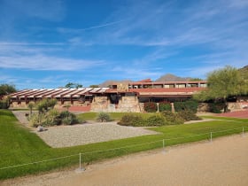
Taliesin West
8.8 miles away
Taliesin West was Frank Lloyd Wright's winter home and architecture school from 1937 until his death in 1959. The campus is still an active school (Frank Lloyd Wright School of Architecture).
Cave Creek Regional Park
11 miles away
Nearly 3,000 acres of Sonoran Desert foothills north of Phoenix, laced with more than fifteen miles of saguaro-lined trails for hiking, mountain biking, and riding, plus old gold-mining country and da...

Camelback Mountain
17 miles away
Camelback Mountain rises 1,420 feet above the Phoenix Basin and has two routes to the summit: Echo Canyon (1.2 miles up, Class 3 scramble with cables) and Cholla Trail (1.8 miles, less technical).
Scottsdale Old Town
18 miles away
Scottsdale's Old Town has the highest concentration of Western art galleries in the United States.

Apache Trail Scenic Drive
24 miles away
The Apache Trail (AZ-88) follows the route used to haul supplies during the Roosevelt Dam construction.