
Cave Creek Regional Park
37900 N Cave Creek Rd
Cave Creek, AZ
Nearly three thousand acres of saguaro-studded desert foothills north of Phoenix, laced with old mining trails and views that seem to stretch for miles once you top the first rise.
Cave Creek Regional Park is a nearly 3,000-acre pocket of true Sonoran Desert wilderness tucked into the foothills north of Phoenix, above the small town of Cave Creek. It is one of the crown jewels of the Maricopa County park system, a place where forests of saguaro cactus climb rocky ridges and more than fifteen miles of trail let you disappear into the desert within an hour of the city.
The land carries a long human story under its cactus and creosote. People sheltered in the cave that gives the creek and the town their name for thousands of years, and in the 1800s gold seekers scrambled over these same jasper-flecked hills chasing a strike. Today the mining is long gone and the desert has reclaimed its own, protected as a park where the main business is walking, riding, and taking in some of the most spacious views in the northern valley.
What Travelers Love
- More than fifteen miles of trails for hiking, mountain biking, and horseback riding
- The Go John Trail's long loop around a mountain, where the desert opens up on every side
- Dense stands of saguaro and Sonoran Desert plants, especially green and blooming in spring
- Big, quiet views and dark skies, close to Phoenix but a world away from the city noise
Worth Knowing
- A small per-vehicle day-use fee supports the county park system, so bring a way to pay at the entrance
- Summer desert heat is serious, so hike early in the day, carry far more water than you think you need, and turn back in the heat of the afternoon
- Trails are shared by hikers, bikers, and horses, so watch your footing and yield courteously
- Stay on the marked trails, keep clear of old mine openings, and never touch or handle desert wildlife
Learn about Cave Creek Regional Park
A cave, a creek, and a very old story
The name goes back to a real cave, a large rock overhang along the creek that people have used for shelter for a very long time. Evidence of human use here reaches back thousands of years, to the desert-dwelling peoples who knew where the water ran and where the rock offered shade. Later the Hohokam farmed and built irrigation across this part of the valley, and Apache groups moved through the foothills, hunting and gathering in the same rugged country the trails now cross.
The creek that flows out of these mountains carried that name downstream, and eventually the town below took it too. Walking the park today, it is worth remembering that the desert underfoot is not empty backcountry but a landscape people have read and used for millennia, drawn by the same shade, water, and shelter that make it a fine place to spend a morning now.
Gold fever in the foothills
In the 1800s, gold discoveries in the nearby Bradshaw Mountains sent prospectors fanning out across central Arizona, and the jasper-studded hills around Cave Creek drew their share of hopeful diggers. Fever-stricken gold seekers staked claims in these foothills, scratching at the rock for a strike that would make them rich, in country still contested between settlers and the Apache who had long lived there.
Most of that mining came to little, and the desert has been steadily erasing its scars ever since. But the old workings and prospect sites left their mark on the land, and some of the park's trails trace routes that miners once used. Those touches of frontier history, set against the saguaros, give a hike here a faint echo of the boom-and-bust era that shaped so much of Arizona.
Miles of trail through the Sonoran Desert
The heart of the park is its trail network, more than fifteen miles of paths open to hikers, mountain bikers, and horseback riders, ranging from short, easy strolls to longer, tougher loops. The best known is the Go John Trail, a nearly six-mile loop that circles a mountain and, for long stretches, gives the illusion of being far from any city, with the desert rolling out in every direction. For a shorter, gentler outing, trails like the Slate route offer a taste of the same country without the full commitment.
What you move through is textbook Sonoran Desert: tall saguaros standing like sentinels, palo verde and ironwood trees, cholla and prickly pear, and, after a wet winter, a spring flush of wildflowers and cactus blooms. Elevations climb from around 2,000 feet up past 3,000, so the trails reward the climb with wide views over the foothills toward the distant central Arizona mountains, and after dark the park's remove from city lights makes for genuinely starry skies.
Visiting Cave Creek Regional Park
The park lies just north of the town of Cave Creek, an easy drive from the Phoenix and Scottsdale area. A modest per-vehicle day-use fee at the entrance supports the county park system, and the visitor area has the basics for a day out. The single most important thing to plan around is the heat: from late spring through early fall the desert sun is punishing, so hike early, carry far more water than seems necessary, wear sun protection, and be off the longer trails before the worst of the afternoon.
Come in the cooler months, roughly fall through spring, and the park is close to perfect, with comfortable days and, in spring, a desert in bloom. Stick to the marked trails, keep your distance from old mine openings and from wildlife, and share the paths courteously with bikers and horses. Whether you want a short saguaro stroll, a long loop into the quiet, or a starry evening near the city, Cave Creek Regional Park delivers a big slice of the real Sonoran Desert right on the edge of the northern valley.
Closest Boutels
The closest Boutel™ stays, so you can turn this stop into an overnight. Each is a place we chose through independent editorial review, never a paid placement.
Details
Cave Creek, AZ
Frequently asked questions
What is Cave Creek Regional Park?
Cave Creek Regional Park is a scenic desert park in the foothills north of Phoenix, near the town of Cave Creek, offering thousands of acres of classic Sonoran Desert for recreation. With miles of trails for hiking, mountain biking, and horseback riding winding among saguaros and desert hills, along with a campground, a nature center, and beautiful desert scenery, it is a popular outdoor escape in the north Valley. The park provides accessible desert trails and wildlife amid rolling terrain, making it a favorite spot for enjoying the Sonoran Desert close to the Phoenix metro area.
What can you do at Cave Creek Regional Park?
You can hike or mountain bike a network of desert trails ranging from easy to more challenging, ride horseback, camp at the campground, visit the nature center to learn about desert plants and wildlife, watch for birds and other creatures, and enjoy picnicking and stargazing under relatively dark skies. The trails wind through saguaro-studded hills with scenic views. With its variety of trails, camping, and interpretive offerings, Cave Creek Regional Park is a versatile and accessible destination for enjoying the Sonoran Desert north of Phoenix.
What safety precautions should I take at Cave Creek Regional Park?
The desert heat is the main hazard, so carry plenty of water, wear sun protection and sturdy shoes, and avoid strenuous trails during the hot midday hours in warm months, hiking early instead. Watch for wildlife like rattlesnakes, especially in warm weather, never touch cacti, and stay on marked trails. Tell someone your plans, since shade and services are limited on longer routes. Knowing your limits and turning back if you overheat helps ensure a safe outing in this desert park.
When is the best time to visit Cave Creek Regional Park?
The cooler months from fall through spring are ideal for hiking, biking, and camping in comfort, with spring bringing lovely wildflowers, while summer is very hot and best limited to early morning outings with ample water. Sunrise and sunset offer beautiful light and cooler temperatures. Mornings are best year-round for both comfort and wildlife. The milder months provide the safest and most pleasant conditions for exploring the park's desert trails and enjoying the Sonoran Desert scenery north of Phoenix.
What is near Cave Creek Regional Park?
The park is north of Phoenix near the towns of Cave Creek and Carefree, known for their Southwestern charm, shops, and dining, with the broader Phoenix metro area and its attractions, including desert preserves and Scottsdale, within reach. That makes Cave Creek Regional Park an easy desert-recreation escape to combine with the artsy towns of Cave Creek and Carefree and the many other attractions of the north Valley and greater Phoenix area on a visit to central Arizona.
Nearby

McDowell Sonoran Preserve
11 miles away
McDowell Sonoran Preserve is one of the largest urban preserves in the US, protecting a significant section of the McDowell Mountains and surrounding Sonoran Desert from development.
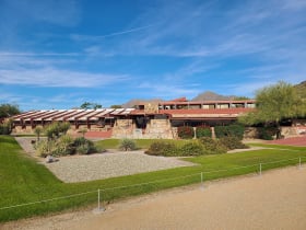
Taliesin West
16 miles away
Taliesin West was Frank Lloyd Wright's winter home and architecture school from 1937 until his death in 1959. The campus is still an active school (Frank Lloyd Wright School of Architecture).

Camelback Mountain
21 miles away
Camelback Mountain rises 1,420 feet above the Phoenix Basin and has two routes to the summit: Echo Canyon (1.2 miles up, Class 3 scramble with cables) and Cholla Trail (1.8 miles, less technical).

Apache Trail Scenic Drive
35 miles away
The Apache Trail (AZ-88) follows the route used to haul supplies during the Roosevelt Dam construction.