
North Cascades Highway (SR-20)
Washington
North Cascades Highway, Washington
The North Cascades Highway is what people picture when they imagine driving through big, wild mountains. This is Washington State Route 20, and its high middle stretch carries you through the heart of the North Cascades, a range so steep and glacier-carved that folks have called it the American Alps. In a single afternoon the road lifts you from thick green river forest up to bare granite passes with snow lingering into summer, then drops you down the other side into sunny high desert country.
This is a drive worth building a trip around. The high part of Highway 20 is part of the Cascade Loop, and in 2021 the whole loop earned the country's National Scenic Byway honor for the way the road strings together glaciers, waterfalls, a lake the color of a swimming pool, and some of the most dramatic mountain scenery in the Lower 48. It is also a road with a catch, since the high section shuts down every winter, which only makes the open months feel more like a gift.
Learn about North Cascades Highway (SR-20)
The Road
State Route 20 is a two-lane paved highway that crosses the top of Washington from the Puget Sound lowlands all the way to the Idaho line. The part travelers mean when they say North Cascades Highway is the mountain heart of it, roughly the run east from the little town of Marblemount, up past a string of dams and lakes, over Rainy Pass and Washington Pass, and down toward Mazama and Winthrop on the dry east side. That mountain stretch covers a bit over sixty miles, though the whole scenic byway route runs longer.
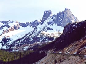
The driving is the kind that makes passengers go quiet. You start along the milky green Skagit River, climb past reservoirs held back by tall dams, and cross a footbridge-style overlook above a plunging waterfall. Higher up the forest thins and the peaks close in, all rock and ice and pointed summits. Washington Pass, the high point at 5,477 feet, delivers the showstopper: a big sweeping hairpin turn with the sheer granite spire of Liberty Bell Mountain rising straight above it. Then the road tips downhill into a drier, sunnier world of pine and open valley.
There are pullouts and short trails all along the way, so you can turn a two-hour drive into an easy full day. The road is fully paved and, when open, needs no special vehicle. What it does need is planning, because once you leave the towns at either end there are no gas stations, no stores, and no services over the high middle. You fill the tank, pack water and snacks, and treat the pass like the remote place it is.
How to Get There
Coming from the Seattle side, the easiest approach is Interstate 5 north to the town of Burlington, then State Route 20 east. From there the highway follows the Skagit River valley up through Concrete, Rockport, and Marblemount, the last real town before the mountains, and climbs into the North Cascades from the west. This is the classic way in, and it puts the waterfalls, dams, and Diablo Lake in front of you first.
Coming from the east, you reach the highway through the Methow Valley towns of Winthrop and Mazama. From central Washington you can follow US Route 97 to State Route 153 and up the Methow Valley to meet SR 20, then drive west up over Washington Pass. Many people make it a big loop, going up one side of the Cascade Loop and back down the other so they never repeat a mile.
Whichever end you start from, the single most important step is to check that the high section of SR 20 is open before you go. Washington's transportation department posts the road's status online, and in the colder months the pass may simply be closed with no way through. When it is open, either direction is a spectacular drive.
History
People dreamed of a road across the northern Cascades for the better part of a century before one existed. The mountains here are so rugged, so tangled with ice and cliff and deep valley, that early survey parties kept turning back. For decades the only ways through were foot trails, mining tracks, and the work roads built to serve the great dams on the Skagit River, which Seattle began raising in the 1920s and 1930s to power the growing city far to the west.
The full highway did not open until September 2, 1972. Crews had to blast and carve a route through terrain that had defeated engineers for generations, especially the wall of rock at Washington Pass, where the road clings to a ledge above a plunging valley. When it finally opened, it connected the wet, forested west side of the state to the sunny Methow Valley on the east for the first time by car, and it instantly became one of the most celebrated scenic drives in the nation.
The route was recognized early as a state scenic byway for its beauty. Its biggest national moment came on January 19, 2021, when the Cascade Loop, the long touring route that includes this stretch of SR 20, was named a National Scenic Byway. That honor is reserved for roads with outstanding scenic, natural, and recreational qualities, and it put the North Cascades Highway on the country's official short list of great drives.
Running alongside all of it is the story of the land itself, most of which is protected. The highway threads through North Cascades National Park and the Ross Lake National Recreation Area, a landscape holding more glaciers than anywhere else in the Lower 48 outside Alaska. The park was established in 1968, a few years before the road opened, so the highway was built to pass through country that Congress had already set aside to keep wild.
Little-Known Facts
- The North Cascades Highway did not open until September 2, 1972, one of the last major mountain crossings in the country to be finished, because the terrain was so steep and tangled that survey crews had struggled with it for generations.
- The high middle of SR 20 closes every winter, usually from around November into spring, because the slopes above the road are so avalanche-prone. It is one of the longest seasonal highway closures in the Lower 48, and crews spend weeks each spring clearing the deep snow before it can reopen.
- Diablo Lake glows an almost unreal turquoise because of glacial rock flour, a fine powder ground from stone by the glaciers above. The tiny particles hang in the water and scatter light, and the color is most vivid in late summer when glacial melt peaks.
- The North Cascades hold more glaciers than any other part of the Lower 48 outside Alaska, over three hundred of them, which is why the range is often nicknamed the American Alps.
- The granite spire towering over Washington Pass is Liberty Bell Mountain, and the smooth walls around it are so prized by rock climbers that people travel from around the world to scale them.
- The lakes the highway passes, including Diablo and Ross, are not natural. They are reservoirs held back by tall dams that Seattle built to make electricity, and the city still lights homes with power generated here more than a hundred miles away.
- There are no gas stations, stores, or services along the high middle of the drive, so the stretch between the towns at each end is a true remote mountain crossing.
- The drive is a journey between two climates. The west side is wet, green, and forested, while just over the passes the east side turns dry, sunny, and open, thanks to the way the mountains wring the rain out of passing storms.
Along the Route
Newhalem and the North Cascades Visitor Center
Newhalem is a tiny company town built for the dam workers, and it makes a natural first stop as you enter the mountains from the west. The North Cascades Visitor Center here is the main gateway to the national park, with free exhibits on the glaciers, forests, and wildlife you are about to drive through. A short loop trail nearby winds among towering old-growth cedars, a quiet, mossy introduction to the wild country ahead.
Gorge Creek Falls
Gorge Creek Falls drops in a tall white ribbon right beside the highway, and you can stop at a pullout and walk out onto a footbridge to peer down into the gorge. It is one of the easiest big waterfalls to reach on the whole drive, since it is only steps from the car. The falls run strongest in late spring and early summer when the snow up high is melting fast.
Diablo Lake Overlook
This is the view that ends up on postcards. From a pullout high above the water, you look straight down onto Diablo Lake, which glows an almost electric turquoise. The color comes from glacial rock flour, a fine powder that glaciers grind from the mountains and that hangs in the water, scattering blue and green light. Snowy peaks rise above the far shore, and the whole scene can look almost too vivid to be real.
Ross Lake Overlook
A short walk from a pullout brings you to a view of Ross Lake, a long reservoir that reaches north all the way to the Canadian border. It is a quieter stop than Diablo, just a few minutes farther up the road, and it gives you a sense of how big and remote this country really is. The lake is held back by a tall dam and, like its neighbors, was built to make electricity for Seattle.
Rainy Pass
Rainy Pass sits at about 4,855 feet, and it is where the famous Pacific Crest Trail crosses the highway on its long walk from Mexico to Canada. From the parking area an easy, mostly paved path leads roughly a mile back to Rainy Lake, a still tarn cupped beneath cliffs and a hanging glacier. It is a gentle stop that gets you out into the high country without a hard climb.
Washington Pass Overlook
Washington Pass is the high point of the drive at 5,477 feet, and its overlook is the grand finale. A short, mostly level loop from the parking lot leads to a railing perched above the highway's dramatic hairpin switchback, with the sheer granite spire of Liberty Bell Mountain soaring straight overhead. It is the single best place to feel just how bold this road is, threaded across a mountain wall. The overlook is only reachable when the highway is open for the season.
Mazama and the Methow Valley
As the highway comes down the east side of Washington Pass, the forest opens up and the country turns sunny and dry. Mazama is the first small settlement you reach, the gateway to the Methow Valley, a wide, pastoral basin of ranches, orchards, and pine-dotted hills. It is a welcome change of scene after the high peaks, and it marks the mellow end of the mountain drive before you reach the Old West town of Winthrop just beyond.
Details
North Cascades
Frequently asked questions
Is the North Cascades Highway a National Scenic Byway?
Yes. The North Cascades Highway, the mountain stretch of Washington State Route 20, is part of the Cascade Loop touring route, which was designated a National Scenic Byway on January 19, 2021. That honor recognizes roads with outstanding scenic, natural, and recreational value. The route had long been celebrated as a state scenic byway before earning the national title.
How long is the North Cascades Highway, and how long does it take to drive?
The wild mountain heart of the drive, from Marblemount over the passes to Mazama and Winthrop, runs a bit over sixty miles, and the full scenic byway route is longer. Driven straight through, the mountain stretch takes roughly two hours, but most travelers give it a half day or a full day so they can stop at the waterfalls, lake overlooks, and passes along the way.
What are the must-see stops along the North Cascades Highway?
Going west to east, the highlights include the North Cascades Visitor Center at Newhalem, Gorge Creek Falls, the famous turquoise Diablo Lake Overlook, the quieter Ross Lake Overlook, Rainy Pass with its trail to Rainy Lake, and the grand Washington Pass Overlook beneath the granite spire of Liberty Bell Mountain. Pullouts and short trails all along the road make it easy to pause.
Is the North Cascades Highway free to drive?
Yes. State Route 20 is a public highway, so driving it costs nothing, and there is no entrance station for the national park it passes through. Some trailheads and recreation sites along the way may ask for a Northwest Forest Pass or a parking fee to leave your car, but the drive itself and its roadside overlooks are free.
Is the North Cascades Highway open year-round?
No. This is the most important thing to know before you go. The high middle section, roughly from the Ross Lake area over Rainy and Washington passes to the Early Winters area on the east side, closes every winter because of avalanche danger. It is typically shut from around November into spring, though the exact dates change each year with the snow. Always check that SR 20 is open before planning to cross the passes.
What is the best time of day and season to drive the North Cascades Highway?
Summer and early fall are the prime window, when the high section is open, the weather is mild, and Diablo Lake glows its brightest from peak glacial melt. Fall adds golden larch trees near the passes. Morning light is beautiful, and getting an early start helps you find parking at the busy overlooks. The drive is off-limits in the deep winter months while the pass is closed.
Do you need four-wheel drive to drive the North Cascades Highway?
No. When the highway is open for the season it is fully paved and any passenger car handles it easily. Four-wheel drive and high clearance are not needed. The one thing that keeps ordinary cars off the road is the winter closure itself, not the road surface, since the high section is simply shut when snow and avalanche danger take over.
What are the winter driving conditions on the North Cascades Highway?
In winter the high middle of the highway is closed entirely, so there is no crossing the passes at all during those months. The lower ends near Marblemount on the west and Mazama and Winthrop on the east stay open but can be snowy and icy, so carry chains and check conditions. If you want to cross the mountains in winter, you will need to take a different route around the closed section.
Are there gas stations and services along the North Cascades Highway?
No. There are no gas stations, stores, or restaurants along the high middle of the drive. Fill your tank and pack food and water in the towns at either end, Marblemount on the west side or Winthrop and Mazama on the east, before you head into the mountains. Treat the pass as a remote stretch and plan to be self-sufficient the whole way across.
Is there cell phone service on the North Cascades Highway?
Not reliably. Cell coverage is spotty to nonexistent across the high mountain section, so do not count on your phone for directions or emergencies once you leave the towns. Download maps ahead of time, tell someone your plans, and note that the visitor center at Newhalem near the west entrance is a good place to get information before the signal drops.
Nearby
North Cascades Highway (SR-20)
0.1 miles away
One of the great mountain scenic drives in the country, climbing over Washington Pass past the granite spires of Liberty Bell Mountain and the turquoise water of Diablo Lake.

Washington Pass Overlook
3.5 miles away
Washington Pass Overlook is right off SR-20 near milepost 162, roughly 30 miles west of Winthrop.

Cascade Pass
16 miles away
Cascade Pass is a classic alpine hike in the North Cascades, climbing switchbacks through forest and meadow to a high pass surrounded by glaciated peaks, hanging glaciers, and tumbling waterfalls.

Ross Lake
21 miles away
Ross Lake is a long, fjord-like reservoir stretching north through the heart of the North Cascades toward the Canadian border, ringed by steep, forested mountains.

North Cascades National Park
26 miles away
Jagged alpine peaks and more than 300 glaciers, one of the most rugged ranges in the lower 48.
Mount Baker Highway
48 miles away
A scenic byway that climbs 58 miles east from Bellingham (SR 542) through farmland and forest to Artist Point at 5,100 feet, with 360-degree views of Mount Baker and Mount Shuksan.