
Cascade Pass
Cascade Pass, North Cascades National Park, WA
Marblemount, WA
Switchback to a high pass surrounded by glaciers, meadows, and jagged peaks.
Cascade Pass is a classic alpine hike in the North Cascades, climbing a series of switchbacks through forest and meadow to a high pass surrounded by glaciated peaks, hanging glaciers, and waterfalls that tumble down the mountainsides. Long used as a travel route through the range by Native peoples and later settlers, it now rewards hikers with sweeping high-country views.
In summer, the meadows near the pass bloom with wildflowers, and marmots whistle among the rocks. From the pass, the even higher Sahale Arm trail climbs on toward a glacier, extending the adventure for those with the energy. Reached by the gravel Cascade River Road, Cascade Pass is a highlight of the park for hikers who love the alpine world of the North Cascades.
What Travelers Love
- A high pass ringed by glaciated peaks and hanging glaciers
- Wildflower meadows in summer
- Waterfalls tumbling from the surrounding mountains
- A connection to the higher Sahale Arm trail
Worth Knowing
- It is inside North Cascades National Park
- The trail is about 7.4 miles round trip, moderate with switchbacks
- Reached by the gravel Cascade River Road; check its status
- Snow can linger into summer; bring layers and check conditions
Learn about Cascade Pass
The hike to the pass
The Cascade Pass Trail runs about 7.4 miles round trip, climbing roughly 1,800 feet. It begins with a long series of well-graded switchbacks up through the forest, then emerges into open meadows with expanding views of the surrounding peaks and glaciers before reaching the pass itself. The switchbacks make the climb steady rather than brutally steep, so many reasonably fit hikers can manage it.
At the pass, the reward is a panorama of jagged, glacier-clad summits, waterfalls, and valleys dropping away on either side. Marmots, pikas, and other alpine wildlife are common, and in summer the meadows are full of wildflowers. Many hikers linger at the pass to soak in the scenery before returning.
Sahale Arm and access
For those wanting more, the trail continues beyond the pass up Sahale Arm, a high ridge that climbs toward the Sahale Glacier with expansive views. This extension adds significant distance and elevation and is more strenuous, but it leads deeper into stunning alpine terrain for strong hikers.
Cascade Pass is reached by driving the gravel Cascade River Road to its end, which can be rough and is subject to closures, washouts, and seasonal conditions, so it is important to check the road's status before setting out. Snow can linger on the high trail into summer, and mountain weather changes fast, so layers, sturdy footwear, water, and checking current conditions are all important.
Closest Boutels
The closest Boutel™ stays, so you can turn this stop into an overnight. Each is a place we chose through independent editorial review, never a paid placement.
Details
Marblemount, WA
Frequently asked questions
What is Cascade Pass?
Cascade Pass is a high mountain pass and a classic alpine hiking destination in North Cascades National Park, Washington. A trail of about 7.4 miles round trip climbs switchbacks through forest and meadow to the pass, which is ringed by glaciated peaks, hanging glaciers, and waterfalls. Long used as a route through the mountains by Native peoples and later settlers, it rewards hikers with sweeping high-country views, summer wildflower meadows, and alpine wildlife like marmots and pikas. From the pass, the higher Sahale Arm trail continues toward a glacier for those wanting more. Reached by the gravel Cascade River Road, Cascade Pass is a highlight of the park for hikers who love its rugged alpine scenery.
How hard is the Cascade Pass hike?
The Cascade Pass hike is considered moderate. It is about 7.4 miles round trip with roughly 1,800 feet of elevation gain, but the climb is spread over many well-graded switchbacks, which makes it steady rather than steep, so many reasonably fit hikers can complete it. The main considerations are the distance, the high elevation, and mountain conditions: snow can linger on the upper trail into summer, and weather changes quickly. Continuing beyond the pass up Sahale Arm is much more strenuous, adding significant distance and steep elevation gain, and is best for strong, prepared hikers. For the standard hike to the pass, bring water, layers, sturdy footwear, and sun protection, start reasonably early, and check trail and road conditions before you go.
How do you get to the Cascade Pass trailhead?
The Cascade Pass trailhead is at the end of the Cascade River Road, a gravel road that heads southeast from the town of Marblemount, Washington, into North Cascades National Park. The drive takes you deep into a mountain valley and ends at the trailhead parking area. The road is gravel and can be rough, narrow, and subject to potholes, washouts, and seasonal closures, so a vehicle with reasonable clearance is helpful, and it is important to check the current road status before you go, since conditions vary and the road is typically closed in winter. Because the trailhead is remote with no services, come prepared with a full tank of gas, water, food, and appropriate gear, and allow extra time for the slow drive on the gravel road.
What is Sahale Arm?
Sahale Arm is a high alpine ridge that extends beyond Cascade Pass, reached by continuing on the trail from the pass. It climbs steeply up open, meadowed slopes toward the Sahale Glacier and a rustic backcountry camp near the glacier's edge, gaining significant additional elevation. The reward is even more expansive views of glaciers, jagged peaks, and deep valleys, with summer wildflowers and frequent sightings of marmots. The full trip to the Sahale Glacier area is considerably longer and more strenuous than the hike to Cascade Pass alone, so it is best for fit, well-prepared hikers with enough time and energy. Many hikers do part of Sahale Arm for the views even if they do not go all the way to the glacier. As always, check conditions and carry proper gear.
Nearby
Gorge Creek Falls
17 miles away
Gorge Creek Falls is a tall, plunging waterfall right beside the North Cascades Highway, where Gorge Creek drops through a deep, rocky gorge on its way to the Skagit River.
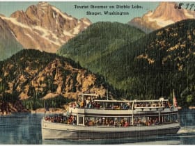
Diablo Lake
17 miles away
Diablo Lake turns a vivid turquoise-to-aquamarine color from glacial flour - fine particles ground from rock beneath the glaciers above that scatter blue and green wavelengths of light.

Ross Lake
18 miles away
Ross Lake is a long, fjord-like reservoir stretching north through the heart of the North Cascades toward the Canadian border, ringed by steep, forested mountains.