
Washington Pass Overlook
State Route 20, Okanogan-Wenatchee National Forest
Mazama, WA
A quarter-mile paved loop delivers one of the most staggering mountain views in the state, straight into the granite spires of Liberty Bell with the highway coiling in the valley below.
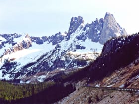
Washington Pass Overlook is the kind of view that makes people gasp out loud, and it asks almost nothing of you to earn it. From the parking area high on the North Cascades Highway, a paved loop of about a quarter mile leads to a railed viewpoint where the ground simply falls away. Straight across the valley stands Liberty Bell Mountain, a sheer granite tower whose north end really does echo the shape of the famous bell in Philadelphia, with the highway itself visible far below, doubling back on itself in a tight hairpin.
This is the roof of the North Cascades Highway, State Route 20, the highest point on the only paved road that crosses the range for a very long way in either direction. That the road exists at all is a small marvel. It was not completed until 1972, one of the last great mountain highways built in the country, and for half the year the snow reclaims it entirely.
What Travelers Love
- A huge alpine payoff for an almost effortless quarter-mile paved loop
- The granite fang of Liberty Bell Mountain rising straight ahead across the valley
- Watching the highway switchback hundreds of feet below through the trees
- Golden larches lighting up the slopes in late September and October
Worth Knowing
- The North Cascades Highway closes over the pass in winter, usually from around November into spring, so check the road status before you go
- At over a mile high the air is cool and weather turns fast, even in summer; bring a layer
- The loop is short and mostly paved, but the drop-offs are real, so keep an eye on children
- It is a popular pull-off, so summer weekends fill the small lot; early or late is calmest
Learn about Washington Pass Overlook
Liberty Bell and the granite spires
The wall of rock you are looking at is one of the most famous climbing playgrounds in the Cascades. Liberty Bell Mountain is the tallest of the group at about 7,720 feet, and it stands in a line of jagged towers that includes the Early Winters Spires and the ridge of Concord and Lexington. Its east face drops a clean 2,000 feet toward the highway, a sweep of pale granite that glows at sunset.
The stone itself is unusual. These peaks are part of the Golden Horn Batholith, a body of granite that cooled from molten rock roughly 49 million years ago. Geologists prize it for a rare speckled pattern called rapakivi texture, pink crystals of feldspar rimmed in white, and for the surprising mix of more than fifty minerals locked inside it. It is a mountain that rewards a long look.
The highway that took decades to build
For most of the twentieth century there was simply no road across this stretch of the North Cascades. Surveyors dreamed of a crossing for generations, but the terrain of avalanche chutes, cliff bands, and deep snow defeated every early attempt. Construction finally pushed through in stages, and the North Cascades Highway opened in 1972, linking the wet, forested west side of the range to the drier pine country of the Methow Valley on the east.
Even now the mountains only lend the road out for part of the year. Heavy snow and avalanche danger force the highway to close over Washington Pass and nearby Rainy Pass through the winter, typically from sometime in November until crews can clear and stabilize it in spring. The reopening each year is a small regional event, a sign that the high country is open again.
Seasons at the pass
Summer is the reliable window, when wildflowers bloom in the meadows near the overlook and the granite is warm and dry. The most magical time, though, is autumn. In late September and October the western larch on the surrounding slopes turn a brilliant gold before dropping their needles, a rare deciduous conifer that sets the whole basin alight and draws photographers from across the region.
Whenever you come, remember how high you are. At more than 5,400 feet the overlook can be cool and breezy even on a hot valley day, and mountain weather can close in quickly. A light jacket in the car is never a mistake.
Wildlife of the high country
The forest around the pass is subalpine, a mix of mountain hemlock, subalpine fir, and those signature larches, thinning toward meadow and bare rock above. Pikas and hoary marmots live in the talus slopes, whistling and squeaking among the boulders, and Clark's nutcrackers work the treetops for pine seeds.
Black bears range through the huckleberry patches in late summer, mule deer browse the edges, and the cliffs draw raptors riding the updrafts. This is also a corridor for some of the state's rarer wide-ranging animals, from mountain goats on the crags to the occasional wolverine passing through the wild country beyond the road.
Closest Boutels
The closest Boutel™ stays, so you can turn this stop into an overnight. Each is a place we chose through independent editorial review, never a paid placement.
Details
Mazama, WA
Frequently asked questions
What is the Washington Pass Overlook?
The Washington Pass Overlook, along the North Cascades Highway in northern Washington, is a spectacular scenic viewpoint high in the North Cascades, offering one of the most dramatic mountain vistas accessible by car in the state. From the overlook, reached by a short walk from the parking area, visitors gaze out at the jagged, towering peaks of the region, most notably the striking Liberty Bell Mountain and Early Winters Spires, along with the highway hairpin turn winding far below and the vast alpine wilderness. A highlight of driving the North Cascades Highway, the Washington Pass Overlook provides breathtaking, easily accessible views of the magnificent and rugged North Cascades.
What can you see from the Washington Pass Overlook?
From the Washington Pass Overlook, you can see dramatic, close-up views of jagged granite peaks, most famously Liberty Bell Mountain and the Early Winters Spires, the deep valley and the highway's sweeping hairpin turn far below, and the vast, rugged alpine wilderness of the North Cascades stretching to the horizon. A short paved and gravel trail from the parking area leads to the viewpoints. The scenery is spectacular and easily accessible. It is a favorite for photography, especially with fall color or fresh snow on the peaks. The stunning, accessible mountain views make the Washington Pass Overlook a must-see stop on the North Cascades Highway.
What should I know before visiting the Washington Pass Overlook?
The Washington Pass Overlook is at high elevation on the North Cascades Highway, which is closed in winter, so it is accessible only during the warmer months, generally late spring through fall, and checking the current road status is essential outside summer. At the overlook, the high elevation means cool temperatures and changeable mountain weather even in summer, so bring layers, and clouds can sometimes obscure the peaks. The short trail to the viewpoints is easy. Being prepared for the seasonal access, elevation, and weather ensures a rewarding visit to the spectacular Washington Pass Overlook.
When is the best time to visit the Washington Pass Overlook?
Summer through early fall is the best and only time to visit, since the North Cascades Highway pass is closed in winter, with summer offering mild weather and full access and early fall bringing beautiful color and often clear, crisp days ideal for the mountain views, while fresh early-season or late-season snow on the peaks can be stunning. Clear days offer the best views of the dramatic peaks. Because the pass closes for winter, aim for summer or early fall, ideally on a clear day, to enjoy the spectacular scenery at the Washington Pass Overlook.
What is near the Washington Pass Overlook?
The Washington Pass Overlook is along the North Cascades Highway in northern Washington, between North Cascades National Park with Diablo Lake to the west and the Methow Valley with the Old West-themed town of Winthrop to the east, near hiking trails and alpine scenery. That makes the Washington Pass Overlook a spectacular stop to combine with Diablo Lake, the North Cascades Highway, Winthrop, and the other attractions of northern Washington on a scenic drive through the state.
Nearby
North Cascades Highway (SR-20)
0.1 miles away
One of the great mountain scenic drives in the country, climbing over Washington Pass past the granite spires of Liberty Bell Mountain and the turquoise water of Diablo Lake.

Cascade Pass
19 miles away
Cascade Pass is a classic alpine hike in the North Cascades, climbing switchbacks through forest and meadow to a high pass surrounded by glaciated peaks, hanging glaciers, and tumbling waterfalls.
Methow Trails
22 miles away
A community-built web of about 120 miles of trail centered on Winthrop, this becomes North America's largest groomed cross-country ski network in winter and free hiking and mountain-biking singletrack...

Winthrop
22 miles away
A whole town dressed as a frontier outpost, wooden boardwalks and false-front stores along Riverside Avenue, at the sunny eastern foot of the North Cascades.

North Cascades National Park
29 miles away
Jagged alpine peaks and more than 300 glaciers, one of the most rugged ranges in the lower 48.