

Arizona Trail at Pine Trailhead
AZT Pine Trailhead, off AZ 87
Pine, AZ
Where the 800-mile Arizona Trail and the 1870s Highline Trail meet beneath the towering Mogollon Rim, in the cool pines above the desert.
Just outside the little town of Pine, a trailhead opens onto two of Arizona's most storied footpaths at once. This is a junction of the Arizona National Scenic Trail, which runs some eight hundred miles from Mexico to Utah, and the Highline Trail, a rugged pioneer route first worn along the base of the Mogollon Rim in the 1870s. From one parking lot, a hiker can step onto a path that links the whole state, or trace a trail that homesteaders used a century and a half ago.
What makes it a destination rather than just a parking spot is the country it opens into. At over five thousand feet, the forest here is cool ponderosa pine, deep green and sweet-smelling, a world away from the saguaro desert most people picture when they think of Arizona. Above it all rises the Mogollon Rim, a dramatic two-thousand-foot wall of rock that the trails climb toward, and it is that combination of high forest, deep history, and big geology that gives the Pine Trailhead its pull.
What Travelers Love
- Being on the 800-mile Arizona National Scenic Trail, one of the great long-distance footpaths in the country, without any commitment beyond a day hike
- The historic Highline Trail, a pioneer path from the 1870s that runs along the base of the Mogollon Rim
- Cool, fragrant ponderosa-pine forest that offers real relief from the Arizona heat at over five thousand feet
- A well-marked, well-maintained trailhead with clear signage and options for hikes, trail runs, and mountain biking
Worth Knowing
- It sits at over five thousand feet, so afternoons can bring summer thunderstorms and winter can bring snow, and it is best hiked in spring and fall
- Carry plenty of water, since reliable water on the trail is limited and seasonal despite the forested setting
- The trails climb toward the Mogollon Rim and can be rocky and steep, so sturdy footwear and a turnaround plan for a day hike are wise
- There is a trailhead parking area but no services, so food, fuel, and water are found in the town of Pine just to the north
Learn about Arizona Trail at Pine Trailhead
Two trails, one trailhead
The Arizona National Scenic Trail is one of only eleven National Scenic Trails in the country, running roughly eight hundred miles from the Mexican border to the Utah line, across desert, canyon, and mountain. Near Pine it follows a passage known as the Highline, and the Pine Trailhead is one of its access points, meaning that anyone who walks out from here is stepping onto a path that, followed far enough, would carry them across the entire state.
Sharing the ground here is the Highline National Recreation Trail, a much older route. Homesteaders established it in the 1870s to connect their scattered settlements along the base of the Mogollon Rim, from Pine eastward toward Christopher Creek, and it traces the foot of that great rock wall for more than fifty miles. Walking it, you are following in the literal footsteps of the pioneers who first tried to make a living in this high, hard country.
Under the Mogollon Rim
The defining feature of this landscape is the Mogollon Rim, pronounced roughly muggy-own, a long escarpment that rises as much as two thousand feet and forms the southern edge of the Colorado Plateau. The trails from Pine thread the transition zone right at its base, where tall ponderosa pines give way upslope to fir, and manzanita, juniper, and oak fill in the drier gaps. Numerous small drainages and seasonal springs cross the path, and the forest smell of warm pine bark is unmistakable.
For a hiker used to the Sonoran Desert, the change is startling. Because of the elevation, the air here is cooler and the shade deeper, and summer in these forests is a genuine escape from the heat below. The Rim itself dominates every view, a rampart of gray and buff rock, and the ambitious can follow the Arizona Trail as it eventually climbs the wall to reach the high, flat pine country on top.
A trail for every ambition
One of the pleasures of the Pine Trailhead is that it serves everyone. A casual visitor can walk out a mile or two into the pines and turn around, enjoying the forest and the Rim views without a hard climb. A stronger hiker can push farther along the Highline, and a serious trekker can use it as a resupply and access point for a long section of the Arizona Trail. Mountain bikers and trail runners share the well-built singletrack too.
Because the terrain climbs toward the Rim, the trails can get rocky and steep the deeper you go, so a day hiker should carry water, watch the time, and pick a sensible turnaround. But the flexibility is the point: this is a place where a family stroll and a two-hundred-mile expedition begin at the very same signboard.
Visiting the Pine Trailhead
The Pine Trailhead lies just south of the town of Pine, off State Route 87, in the Tonto National Forest, an easy drive up from the Phoenix area and into cooler, higher country. There is a parking area at the trailhead with clear signage for both the Arizona Trail and the Highline Trail, but no other services, so stock up on water, food, and fuel in Pine, which sits just to the north.
Aim for spring or fall, when the weather is mildest. At this elevation, summer afternoons can bring sudden thunderstorms, so hike early and watch the sky, and winter can bring snow to the trail. Carry more water than you think you need, since forested does not mean wet and reliable water sources are seasonal. Whether you want a short forest walk or the start of a long adventure, this trailhead delivers a real slice of Arizona's high-country wilderness.
Closest Boutels
The closest Boutel™ stays, so you can turn this stop into an overnight. Each is a place we chose through independent editorial review, never a paid placement.
Details
Pine, AZ
Frequently asked questions
What is the Arizona Trail Pine Trailhead?
The Arizona Trail Pine Trailhead, in the small community of Pine in central Arizona's Rim Country, is a popular access point to the Arizona National Scenic Trail, an epic long-distance path stretching some eight hundred miles across the entire state from Mexico to Utah. From this trailhead, hikers and mountain bikers can access scenic sections of the trail through the pine forests and beneath the dramatic Mogollon Rim, including the beautiful Highline Trail area. It offers a convenient gateway to day hikes or longer treks amid the refreshing high-country scenery of the Rim.
What is the Arizona National Scenic Trail?
The Arizona National Scenic Trail is a spectacular long-distance trail running roughly eight hundred miles from the Mexico border to the Utah state line, traversing an incredible diversity of Arizona landscapes, from desert and sky-island mountains to the Mogollon Rim's pine forests and the Grand Canyon. Popular with thru-hikers, day hikers, and mountain bikers, it showcases the state's natural beauty in one continuous route. The Pine Trailhead provides access to one scenic segment, letting visitors sample this renowned trail without committing to its full length.
What can you do at the Arizona Trail Pine Trailhead?
You can set out on day hikes or longer backpacking trips along the Arizona Trail through the pine forests beneath the Mogollon Rim, connect to the scenic Highline Trail that runs along the base of the Rim, or mountain bike allowed sections. The trailhead offers parking and access for outings of many lengths, from short walks to ambitious treks. With beautiful forest scenery, Rim views, and connections to a legendary long-distance trail, the Pine Trailhead is a rewarding starting point for exploring central Arizona's high country on foot or by bike.
When is the best time to hike from the Arizona Trail Pine Trailhead?
Late spring through fall offers the most pleasant weather at this high elevation, with summer providing a cool escape from the desert heat and fall bringing beautiful color, while winter can bring snow that makes the trails harder to access. Summer afternoons may bring thunderstorms, so morning starts are wise. Carry plenty of water and sun protection year-round. For comfortable hiking and biking amid the pine forests and Rim scenery, the warm-weather months from late spring through fall are ideal at this trailhead.
What is near the Arizona Trail Pine Trailhead?
The trailhead is in Pine, in central Arizona's Rim Country, near the community of Strawberry, Tonto Natural Bridge State Park, the town of Payson, and the Mogollon Rim with its overlooks and lakes like Woods Canyon Lake. That makes the Arizona Trail Pine Trailhead a great starting point to combine with Tonto Natural Bridge, the Rim's scenic drives and lakes, and the cool pine forests of central Arizona on a high-country hiking getaway.
Nearby
Tonto Natural Bridge State Park
3.3 miles away
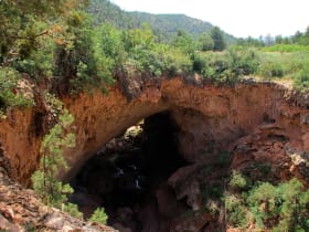
Tonto Natural Bridge is a natural arch formed by travertine deposits building up over centuries from a spring.
Mogollon Rim
5.9 miles away
A thousand-foot escarpment marking the southern edge of the Colorado Plateau, running for two hundred miles with cool Ponderosa pine forest on top and the desert falling away below.

Fossil Springs
7.6 miles away
One of Arizona's largest springs pours tens of millions of gallons a day of clear, seventy-degree water from the base of the Mogollon Rim, building turquoise travertine pools and waterfalls in a deser...
Red Rock Scenic Byway
28 miles away
Red Rock Scenic Byway follows AZ-179 for about seven miles between the Village of Oak Creek and Sedona, threading past some of the most photographed red rock in the Southwest.