
UT-12 Scenic Byway
Utah
Scenic Byway 12, Utah
Some roads connect two towns. Scenic Byway 12 connects two national parks, three national monuments and forests, and about a dozen different worlds, all strung along a single ribbon of Utah pavement. In roughly 124 miles it carries you from the vermilion hoodoos near Bryce Canyon, out across the slickrock canyons of Grand Staircase-Escalante, over a knife-edge ridge with the land dropping away on both sides, and up into cool aspen forest on the shoulder of Boulder Mountain before easing down to Torrey at the doorstep of Capitol Reef.
This is a drive the federal government named an All-American Road, the very highest honor in the country's scenic byway system, reserved for routes so exceptional that the road itself is the destination. Locals call it A Journey Through Time, because in the span of a single afternoon you cross rock laid down over hundreds of millions of years and pass towns that got their first paved road within living memory. It is not a route to rush. It is a route to give a whole day to, and then wish you had given two.
Learn about UT-12 Scenic Byway
The Road
Scenic Byway 12 is a paved, two-lane highway that runs across the high country of south-central Utah, from a junction with US-89 near Panguitch in the west to the town of Torrey in the east. The full byway covers about 124 miles. There is no single overlook that sums it up, because the whole point of Highway 12 is how completely the scenery changes from one end to the other. You begin among red rock hoodoos, drop into deep sandstone canyons, climb a bare stone spine, and finish in a green mountain forest, all on the same road.
The driving experience swings from gentle to genuinely thrilling. Much of the byway rolls along at an easy pace past pullouts and trailheads, but two stretches stand out. One is the Hogback, a narrow section that rides the top of a stone ridge with the ground falling away steeply on both sides and no guardrail in places. It is perfectly safe when you take it slowly and keep your eyes on the road, but it is not a place to hurry or to gawk while driving, so let a passenger do the looking. The other is the long climb over Boulder Mountain, which lifts the highway to around 9,600 feet, high enough that the air cools, the trees change to aspen and spruce, and the whole desert you just crossed spreads out below the overlooks.
What makes Highway 12 so special is how much wild, protected country it threads together in one drive. It brushes Red Canyon and Bryce Canyon National Park at the west end, runs for miles through Grand Staircase-Escalante National Monument in the middle, crosses the Dixie National Forest over Boulder Mountain, and lands you near Capitol Reef National Park at the east end. Between the towns of Panguitch, Escalante, Boulder, and Torrey there are long, empty, gloriously quiet stretches with no services at all, which is part of why the drive feels less like a commute and more like a small expedition.
How to Get There
The classic way to drive Scenic Byway 12 is from west to east, so the scenery builds from red rock canyons up to the high forest and finishes at Capitol Reef. Coming from the Las Vegas or St. George direction, take Interstate 15 north to the Panguitch area, then follow US-89 to the junction where Highway 12 begins, a few miles south of Panguitch. Turn east onto Highway 12 and you are on the byway within minutes, entering through the vivid arches of Red Canyon.
Coming from Salt Lake City or the north, the simplest approach is to drive south on Interstate 15 and then east toward Panguitch and the western end of Highway 12. Travelers already in Bryce Canyon Country can pick up the byway right at Bryce, since Highway 63 to the park spurs directly off Highway 12. From the east, if you are coming through Capitol Reef National Park on Highway 24, you reach the town of Torrey, where Highway 12 begins and heads south to make the same journey in reverse, over Boulder Mountain first.
Either direction is a wonderful drive, but many travelers prefer to start near Panguitch and finish at Torrey, so the road saves its cool green mountain and the red cliffs of Capitol Reef for the grand finale. Whichever way you go, fill your gas tank in a town before you set out, because the stretches in between are long and remote.
History
For most of its length, Highway 12 is a young road cut through very old country. Boulder, the small town near its midpoint, was one of the most isolated communities in the United States well into the twentieth century, so cut off by canyons and cliffs that it was among the last towns in the country to receive its mail by mule train. The trip in and out was made on foot or by pack animal over routes that no wagon could follow, and the idea of a paved highway across that terrain seemed nearly impossible.
The heart of the byway was built by the Civilian Conservation Corps during the Great Depression. Crews began the difficult stretch toward Boulder in 1935 and finished it in 1940, blasting and grading a route across slickrock and along the top of the Hogback ridge. Its builders were so proud of the effort, and so aware of what it cost, that they nicknamed it the Million Dollar Road to Boulder. When the road opened on June 21, 1940, it finally gave Boulder its first year-round automobile connection to the outside world, ending the era of the mail mule. Even so, the country was so rugged that the section of Highway 12 north of Boulder, over Boulder Mountain, was not fully paved until 1985, within the lifetimes of many drivers who now cruise it.
Recognition of the road's beauty came in stages. Scenic Byway 12 was named a National Forest Scenic Byway in 1988, then a Utah State Scenic Byway in 1990. Its national moment arrived in 2002, when the Federal Highway Administration designated it an All-American Road, the highest honor in the country's scenic byway system and one held by only a few dozen roads nationwide. That top designation is reserved for routes with features so exceptional they are considered a destination in their own right, and Highway 12 earned it for a rare combination of scenic, geological, recreational, and historic qualities packed into a single drive.
The rock that makes the journey worth taking is far older than any of this. Along its length the byway cuts through the layers of the Grand Staircase, a vast series of stone steps and cliffs, exposing formations laid down over roughly 200 million years, from ancient deserts to shallow seas. That long geological story, read layer by layer as you drive, is exactly why the byway carries its nickname, A Journey Through Time. The hoodoos of Bryce, the petrified wood near Escalante, and the domes of Capitol Reef are all chapters of the same immense record, and Highway 12 is the page-turner.
Little-Known Facts
- Scenic Byway 12 was designated an All-American Road by the Federal Highway Administration in 2002, the highest honor in the national scenic byway system, held by only a few dozen roads in the entire country.
- The heart of the route, the stretch toward Boulder, was built by the Civilian Conservation Corps between 1935 and 1940, and its builders nicknamed it the Million Dollar Road to Boulder for the sheer difficulty and cost of carving it across the slickrock.
- The town of Boulder was one of the last communities in the United States to receive its mail by mule train, because the surrounding canyons were too rugged for any wagon or car until the road opened on June 21, 1940.
- The section of Highway 12 north of Boulder, climbing over Boulder Mountain, was not fully paved until 1985, meaning the byway was only completely paved within the memory of many people alive today.
- The most dramatic stretch, the Hogback, rides along the narrow top of a stone ridge with deep canyons carved by Boulder Creek and Calf Creek falling away on both sides, and in places there is no guardrail at all.
- Kodachrome Basin State Park, just off the byway, was named by a National Geographic team for the vivid color film of the day, because the reds and whites of its sandstone chimneys looked so saturated.
- The byway crosses roughly 200 million years of rock as it climbs and drops through the Grand Staircase, which is why it carries the nickname A Journey Through Time.
- Boulder Mountain lifts the highway to around 9,600 feet, high enough that the desert scrub gives way to aspen and spruce forest, and the road can catch snow and briefly close in winter long after the canyons below have thawed.
Along the Route
Red Canyon
Just after the byway leaves US-89, Highway 12 dives straight through Red Canyon, where the road passes under two short tunnels blasted through vermilion rock. The hoodoos and fins here glow a deeper red than almost anything at nearby Bryce, and easy trails and a paved bike path run right alongside the highway. It is the byway's first great scene, and it arrives within minutes of the start.
Bryce Canyon National Park
A short spur, Highway 63, turns off the byway and climbs to the rim of Bryce Canyon, one of the most astonishing sights in the Southwest. From the overlooks you look down into vast natural amphitheaters filled with thousands of orange and pink hoodoos, the tall stone spires that Bryce is famous for. Even if you only have an hour, the drive up and a walk to a single viewpoint is well worth the detour.
Kodachrome Basin State Park
Reached by a spur road near the town of Cannonville, Kodachrome Basin is a hidden bowl studded with tall sandstone chimneys in bands of red and white. A National Geographic team gave it the name for the popular color film of the era, because the rock looked so richly saturated. Short, gentle trails wind among the spires, making it an easy and rewarding side trip off the main byway.
Grand Staircase-Escalante National Monument
For many miles through the middle of the byway you are traveling across Grand Staircase-Escalante, one of the largest and wildest tracts of public land in the Lower 48. This is a country of slot canyons, hidden arches, and long empty vistas, best known for how little of it has been tamed. The town of Escalante is the gateway and the last good place to fuel up and stock up before the remote stretches ahead.
Escalante Petrified Forest State Park
Just outside the town of Escalante, a short loop trail climbs a hill scattered with chunks of colorful petrified wood, ancient logs turned to stone and streaked with reds and purples. Below the hill sits a reservoir that is a welcome spot for a swim on a hot day. It is a quick, satisfying stop that pairs a bit of a leg stretch with a look at deep geological time.
Calf Creek Falls
One of the byway's signature adventures, Lower Calf Creek Falls is reached by a hike of about six miles round trip up a sandy canyon inside Grand Staircase-Escalante. The trail follows a clear creek past old ranch and ancestral sites to a tall waterfall that pours into a cold green pool at the base of a stone amphitheater. It is a longer stop, so plan for a half day and carry plenty of water.
The Hogback
The Hogback is the byway's most famous and most dramatic stretch, where the road runs along the narrow top of a stone ridge with deep canyons dropping away on both sides. In places there is no guardrail, and the views are so vast it can feel like driving along the spine of the world. It is safe to drive when you go slowly and keep your attention on the road, so let a passenger take in the scenery here rather than the driver.
Boulder and Anasazi State Park Museum
Just past the Hogback, the byway reaches Boulder, a tiny town that was among the last in the country to get its mail by mule train. Right along the road, Anasazi State Park Museum preserves the excavated foundations of one of the region's larger Ancestral Puebloan villages, with a reconstructed dwelling you can step into. Boulder is also a good place to top off the gas tank before the climb over the mountain.
Boulder Mountain
North of Boulder the byway makes its highest climb, lifting to around 9,600 feet as it crosses the shoulder of Boulder Mountain through cool aspen and spruce forest. Overlooks along this stretch open toward the Henry Mountains and the vast slickrock country you just crossed, a striking contrast of green pines above and red desert below. Because of the elevation, this section can catch snow and briefly close in winter, so check conditions in the colder months.
Torrey and Capitol Reef National Park
The byway ends at Torrey, a small, friendly town with places to fuel up, eat, and rest at the foot of the eastern high country. From here it is just a short drive on Highway 24 to Capitol Reef National Park, where the Waterpocket Fold buckles the earth into a wall of golden domes and cliffs. Torrey makes a natural base for exploring the eastern end of the drive and the park beyond.
Details
Bryce Canyon to Capitol Reef Country
Frequently asked questions
When was Scenic Byway 12 designated an All-American Road?
Scenic Byway 12 was designated an All-American Road by the Federal Highway Administration in 2002. That is the highest honor in the national scenic byway system, reserved for routes considered a destination in their own right. The road was already a National Forest Scenic Byway from 1988 and a Utah State Scenic Byway from 1990 before earning the national title.
How long is Scenic Byway 12, and how long does it take to drive?
Scenic Byway 12 runs about 124 miles from its junction with US-89 near Panguitch to the town of Torrey. Driven without stopping, it takes roughly three hours, but that misses the point of the drive. Most travelers give it at least four to five hours, and a full day is better, so there is time for the overlooks, short hikes, and side trips along the way.
What are the must-see stops along Scenic Byway 12?
Traveling from west to east, the highlights include Red Canyon and the spur to Bryce Canyon National Park near the start, Kodachrome Basin State Park and the town of Escalante in the middle, the Calf Creek Falls hike and the dramatic Hogback ridge, the town of Boulder with Anasazi State Park Museum, and the high climb over Boulder Mountain before the road ends near Capitol Reef National Park at Torrey.
Is it free to drive Scenic Byway 12?
Yes, driving the byway itself is free, since it is a public state highway. Some of the places along the way charge an entrance fee, such as Bryce Canyon National Park, Capitol Reef National Park, and the state parks like Kodachrome Basin, but the road itself and its many pullouts and overlooks cost nothing to enjoy.
What is the best time of day and year to drive Scenic Byway 12?
Late spring through early fall is the most reliable window, when the whole route, including Boulder Mountain, is usually clear and open. Early morning and the last hours before sunset bring out the deepest color in the red rock and the softest light on the canyons. Summer is beautiful but can be hot and busy at the parks, so many travelers favor May, June, September, and October.
Is Scenic Byway 12 open year-round?
The byway is generally open year-round, but it is not a summer-only versus closed-all-winter road. The lower canyon sections stay open, while the highest stretch, over Boulder Mountain at around 9,600 feet, gets real snow and can become slick or close briefly during and after winter storms. If you are driving in the colder months, check current road and weather conditions before you set out.
Do you need four-wheel drive to drive Scenic Byway 12?
No. Scenic Byway 12 is fully paved for its entire length, and any ordinary passenger car handles it easily in good weather. Four-wheel drive or high clearance is only needed for some of the unpaved back roads and slot-canyon routes that branch off the byway, not for the main highway itself.
What are the winter driving conditions on Scenic Byway 12?
In winter, the canyon sections usually drive fine, but the climb over Boulder Mountain is a different story. At around 9,600 feet it collects snow and ice and can be slick, and it may close for a time during heavy storms. Carry appropriate tires or chains in the cold season, give plows and treatment time to work, and check the latest road conditions before crossing the mountain.
Are there gas stations and services along Scenic Byway 12?
Fuel and services are found in the towns along the route, mainly Panguitch near the west end, Escalante in the middle, Boulder past the Hogback, and Torrey at the east end. Between those towns there are long, remote stretches with no gas, food, or reliable services at all. The simplest rule is to fill your tank in a town before you set out and never let it run low on the empty sections.
Is the Hogback section dangerous to drive?
The Hogback is safe to drive when you take it slowly, but it is narrow and demands your attention. The road runs along the top of a stone ridge with steep canyons dropping away on both sides, and in places there is no guardrail. Keep to a comfortable speed, stay in your lane, and let a passenger do the sightseeing rather than the driver. Use the marked pullouts if you want to stop and look.
Nearby

UT-12 Scenic Byway
0.0 miles away
Utah Highway 12 runs 124 miles from US-89 near Panguitch to Torrey near Capitol Reef, crossing five distinct geological formations and three national park corridors.

Gifford Homestead
11 miles away
The Gifford Homestead is a beautifully preserved Mormon pioneer farmhouse in the historic Fruita district of Capitol Reef, set among green orchards beside the Fremont River.

Capitol Reef National Park
12 miles away
A hundred-mile wrinkle in the earth called the Waterpocket Fold, plus historic orchards you can still pick from.

Hickman Bridge
12 miles away
Hickman Bridge is a graceful 133-foot natural rock bridge and one of the most popular short hikes in Capitol Reef.

Cassidy Arch
12 miles away
Cassidy Arch is a dramatic sandstone arch that hikers can actually walk on top of, reached by a moderately strenuous trail climbing from Grand Wash.

Capitol Gorge
14 miles away
Capitol Gorge is a narrow, twisting canyon at the end of the Scenic Drive, where sheer sandstone walls close in overhead and an easy trail follows the sandy wash floor.
Anasazi State Park Museum
16 miles away
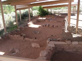
This small state park preserves the Coombs Site, one of the larger Ancestral Puebloan villages excavated in the region, with foundations visible in place and a full-size six-room replica dwelling you...

Bryce Canyon National Park
57 miles away
The largest concentration of hoodoos on Earth, a natural amphitheater of orange and pink stone spires.