
Proxy Falls
NF-2649 off OR-242
Blue River, OR
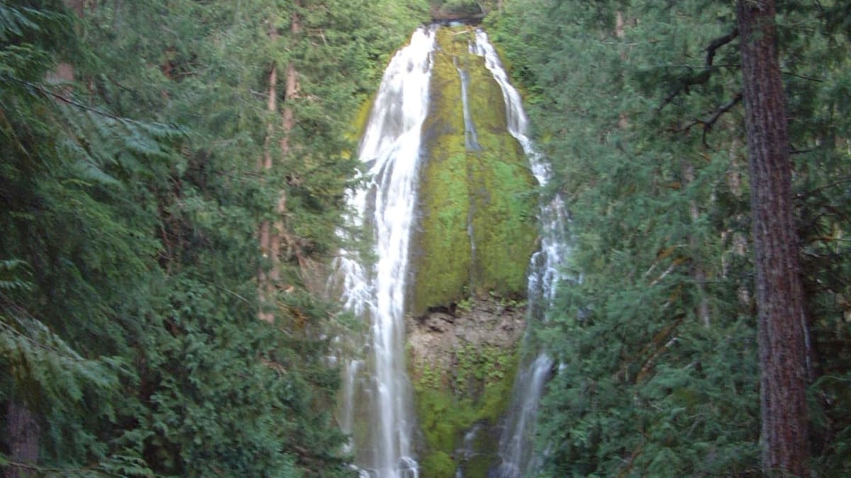
A tall ribbon of water fans down a moss-draped lava cliff into a pool that simply vanishes, swallowed by the porous rock with no stream to carry it away.
Proxy Falls is one of the most photographed waterfalls in Oregon, and for good reason. A tall ribbon of water, more than two hundred feet of it, fans out into a shimmering veil as it slides down a cliff cloaked in brilliant green moss. The short loop trail that reaches it threads through raw black lava flows one minute and cathedral old-growth forest the next, so the walk itself is half the reward.
The falls hide a genuine natural riddle. The pool at their base has no visible outlet, no stream running away downhill. Instead the water simply sinks into the porous lava rock and disappears underground. It is not folklore but a real quirk of the volcanic ground here, and it gives an already beautiful place a touch of the uncanny.
What Travelers Love
- A tall, delicate veil of water fanning down a green wall of moss and lava
- The strange pool at the base with no visible outlet, where the creek sinks into the rock
- A short loop that crosses raw old lava flows one moment and deep old-growth forest the next
- The wild drama of the McKenzie Pass high country all around it
Worth Knowing
- The McKenzie Pass highway is closed by snow in winter and usually opens only from roughly late June into early November, so the falls are unreachable by car much of the year
- In season a paid, reserved wilderness day-use permit is required, plus a parking pass, so check the current rules before you go
- There are no railings, and the short spur to the base is steep and rough with a log crossing, so watch your footing
- The moss, lava, and creek are fragile, so stay on the trail and let others enjoy an untrampled place
Learn about Proxy Falls
A waterfall that vanishes
Lower Proxy Falls, the one everyone comes to see, drops roughly two hundred and twenty-six feet down a moss-covered basalt cliff, fanning out as it falls into a wide, veil-like sheet. It is not a single thundering plunge but a soft, spreading horsetail of water, and against the vivid green of the moss it looks almost too picturesque to be real.
The oddity is at the bottom. The pool at the base of the falls has no surface outlet, no creek carrying the water onward. The flow simply drains down into the porous lava rock beneath and travels away underground. It is one of the most striking examples in the region of how young volcanic ground can swallow a stream whole, and it leaves visitors puzzling at a waterfall that seems to feed a pool going nowhere.
A second, quieter waterfall, Upper Proxy Falls, sits farther along the same loop, reached by following a creek up through the forest. It is broader and lower than its famous neighbor, an easy add-on for anyone doing the full circuit, and it rewards the extra few minutes with a more secluded scene.
Lava, ice, and old growth
The whole setting is a lesson in how the Cascades were built. The valley floor here was flooded by young lava flows spilling from cinder cones near the Three Sisters volcanoes, and the loop trail actually crosses those old flows, where sparse pioneer plants cling to the black, broken rock. It is a stark, otherworldly stretch that gives way abruptly to deep forest.
The falls themselves pour over cliffs shaped by glaciers, which carved the steep headwall at the end of a hanging valley in the ice ages. The plunging water and the porous lava beneath combine to produce the outlet-free pool, a small collision of ice-age sculpting and volcanic plumbing.
Along the shaded sections the trail runs through classic Cascade old growth, tall Douglas fir and western hemlock, deep moss, and a lush green understory. The contrast between the barren lava and the dripping forest, sometimes only steps apart, is one of the quiet marvels of the walk.
The people of the McKenzie country
The central Cascades and the McKenzie River country are, and remain, connected to several Native peoples. The Molalla, including the Santiam Molalla, have long ties to the western Cascade slopes and the headwaters of the McKenzie and neighboring rivers. Below in the valley, the Kalapuya peoples traveled up into these mountains each summer to gather huckleberries, hunt elk, and fish, keeping seasonal camps in the high country.
East of the Cascade crest, the Northern Paiute and the peoples of the Confederated Tribes of Warm Springs have their own enduring ties to the mountains, crossing them to gather and hunt. Rather than belonging to any single nation, this high country served as a shared, common-use area laced with trails running both north and south and east and west, and obsidian from the McKenzie area was traded far and wide.
Today those connections continue through living governments, among them the Confederated Tribes of Grand Ronde, whose members include Kalapuya and Molalla descendants, and the Confederated Tribes of Warm Springs. These are present communities with present ties to this land, and the trails and food-gathering grounds of the Cascades remain part of who they are.
The high road over the pass
Proxy Falls is reached by the Old McKenzie Highway, a narrow, twisting scenic byway that climbs to the crest of the Cascades. It is closed by snow every winter and typically opens only from roughly late June into early November, which is the single most important thing to know before planning a visit. When the road is closed, the falls are effectively out of reach by car.
The drive itself is a destination. Near the summit stands the Dee Wright Observatory, an open shelter built of lava stone during the 1930s, set in the middle of a vast young lava flow. From its steps a peak-finder names the mountains all around, the Three Sisters, Mount Washington, Belknap Crater, and more, and a short interpretive trail loops out across the lava.
This is a landscape of superlatives, some of the youngest lava in Oregon spread beneath a ring of snow-capped volcanoes. Pairing Proxy Falls with a stop at the observatory turns a waterfall hike into a full tour of the volcanic high country, best enjoyed on a clear summer or autumn day when the road is open and the peaks are out.
Visiting Proxy Falls
Plan your visit around the road first. Because the McKenzie Pass highway closes for snow, summer and fall are the seasons to come, and even then the small trailhead fills quickly on weekends. In season the falls also lie within a permitted wilderness area, which means a reserved, paid day-use permit is required along with a parking pass, so it is worth checking the current rules before you set out, as the program can change from year to year.
The loop is short, roughly a mile and a half, but it is not a groomed stroll. The forest-and-lava trail is signed for one-way travel to ease congestion, and the spur down to the base of the falls is steep and rough, including a log crossing, with no railings anywhere near the water. Sure footing and care matter here.
Above all, tread lightly. The moss, the young lava, and the creek-side ground are fragile and easily damaged, and part of what makes Proxy Falls so lovely is that it has been kept that way. Stay on the trail, take your time, and let this quiet, luminous place stay luminous for the next person up the path.
Closest Boutels
The closest Boutel™ stays, so you can turn this stop into an overnight. Each is a place we chose through independent editorial review, never a paid placement.
Details
Blue River, OR
Frequently asked questions
When is Proxy Falls accessible?
Only when the mountain highway that reaches it is open, which is roughly late June through October. The McKenzie Highway over the pass is closed by snow in winter and usually opens around the third week of June, so plan a summer or early-fall visit and check current road status before you drive up. The trail itself is easy once you are there.
How hard is the hike to Proxy Falls?
Easy and family-friendly. A loop of about a mile and a half winds through old lava flows and forest to viewpoints of both the upper and lower falls, gaining very little elevation and taking most people well under an hour. The footing crosses lava rock and can be uneven, and it gets slick near the falls, so wear decent shoes and watch your step at the overlooks.
How do I avoid the crowds at Proxy Falls?
It is a popular, easy-to-reach waterfall, so the small trailhead lot fills and the loop gets busy by mid-morning in summer. The simplest fix is to arrive early, ideally on a weekday, or visit in the quieter shoulder weeks of the open season. Parking is limited, so an early start also spares you circling for a spot.
Can you swim at Proxy Falls?
It is best enjoyed by looking rather than climbing in. The pools and rocks around the falls are slippery and the setting is fragile and much-loved, so visitors are asked to stay on the trail and at the designated viewpoints rather than scrambling to the base or wading in. Admiring the two misty veils from the overlooks is the way to experience it, and it keeps both you and the site safe.
What should I know before visiting Proxy Falls?
The trailhead has a vault toilet and usually requires a day-use fee or a forest recreation pass, so come prepared. The same scenic highway also passes the Dee Wright Observatory and its lava fields, so many people pair the two on one drive. Bring water and a layer, and remember the winding mountain road is not suited to long RVs or trailers.
Nearby
Tamolitch Falls (Blue Pool)
6.0 miles away
The McKenzie River disappears entirely into a porous lava field 1.5 miles upstream from Tamolitch and travels underground the whole way.

Dee Wright Observatory, McKenzie Pass
9.5 miles away
The Dee Wright Observatory was built in 1935 by the Civilian Conservation Corps from the same lava rubble covering McKenzie Pass, making the structure nearly invisible against the black rock field.

Sahalie and Koosah Falls
12 miles away
Sahalie Falls drops 100 feet and Koosah Falls drops 70 feet on the upper McKenzie River within half a mile of each other, both fed by water that surfaces from Clear Lake above.
McKenzie River Swimming Holes
20 miles away
Several pull-outs along Hwy 126 between Vida and McKenzie Bridge give access to swimming with varying depth and current. The water is cold from snowmelt and volcanic springs even on hot days.