
Mount Blue Sky Scenic Byway
Colorado
Some roads take you up a mountain. The Mount Blue Sky Scenic Byway takes you to the very top of one, higher than any other paved road on the continent. Following Colorado Highway 5 out of the old gold-rush town of Idaho Springs, it climbs more than seven thousand feet in about twenty-eight miles, carrying you out of the pine forest, up through wind-bent stands of ancient trees, and finally onto the bare, rocky roof of the Rocky Mountains at 14,130 feet.
This is a National Forest Scenic Byway, a road the US Forest Service singled out for its rare scenery, and driving it feels less like a road trip and more like an expedition. You pass glacier-carved lakes, share the pavement with mountain goats and bighorn sheep, and watch the whole world drop away below you. On a clear day the view from the top stretches for a hundred miles across Colorado. It is one of the most extraordinary approaches to any stay in the mountains west of Denver.
Learn about Mount Blue Sky Scenic Byway
The Road
The byway is really two roads joined together. From Idaho Springs it begins on Colorado Highway 103, a winding forest road that climbs about thirteen miles up to Echo Lake at roughly 10,600 feet. There, at the Echo Lake area, Colorado Highway 5 branches off and heads for the sky. Highway 5 is the part that makes the byway famous, a narrow paved ribbon that switchbacks another fifteen miles up to the summit parking area near the top of Mount Blue Sky. From bottom to top the drive gains more than seven thousand feet of elevation, which is why the air feels so thin by the time you reach the end.
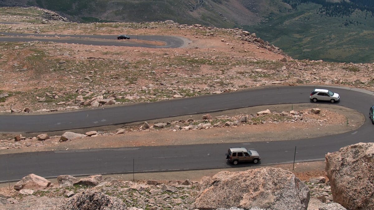
The driving experience changes with every thousand feet you climb. Down low you are among thick evergreen forest. Higher up the trees thin out and shrink into a windswept zone called krummholz, where the wind sculpts them into low, twisted shapes. Above the treeline the world turns to alpine tundra, a fragile carpet of tiny plants, rock, and long views. Near the very top the road hugs the mountainside in tight curves, and in some places there is no guardrail between the pavement and the drop. Take it slowly, keep your eyes on the road, and use the pullouts when you want to look.
What makes Highway 5 special is that it is the highest paved road in North America, and it feels like it. The road is narrow, with steep grades and sharp switchbacks, and vehicles longer than thirty feet are not allowed on it. The reward for the climb is a landscape most people never see from a car window: alpine lakes cupped in glacier-carved bowls, herds of shaggy mountain goats picking across the rocks, and a summit view that on a clear day takes in mountain ranges a hundred miles away.
How to Get There
Most travelers reach the byway from Denver, and it is an easy drive to find. Head west out of Denver on Interstate 70 for about thirty miles to Idaho Springs, a historic mining town tucked in a canyon along Clear Creek. Leave the interstate at Idaho Springs and follow Colorado Highway 103, which climbs south and east up toward Echo Lake. This first stretch is open year-round and is a lovely forest drive on its own.
At Echo Lake, Colorado Highway 5 turns off and heads up to the summit. This is the fee-gated, upper portion of the byway and the part with limited seasons and possible reservations, so it pays to check ahead before you go. From Echo Lake it is about fifteen miles of steady climbing to the summit parking area near the top of Mount Blue Sky.
You can also approach from the mountain town of Evergreen or from the Bergen Park area by taking Colorado Highway 103 from the north, which meets the same route down to Echo Lake. Whichever way you come, plan to arrive at the upper gate earlier in the day. Mornings tend to be clearer and calmer, and afternoon thunderstorms are common and can turn dangerous fast at these heights.
History
The road to the summit was a bold idea from the very start. Construction began in 1923 as a Denver-area project to build a scenic highway all the way to the top of a fourteen-thousand-foot peak, something no other road in the country attempted. Crews blasted and graded their way up the mountain through short summer seasons, and the road was finished around 1930. It opened to the public in June of 1931, and for decades it has carried travelers higher by car than any other paved road on the continent.
For most of its life the mountain and the byway carried the name Mount Evans, after John Evans, a territorial governor of Colorado. In 2023 the name was changed. The US Board on Geographic Names voted to rename the peak Mount Blue Sky, and the byway was renamed to match. The new name honors the Cheyenne people, sometimes called the Blue Sky People, and the Arapaho, both of whom hold the mountain sacred. The change came because the old name honored a governor connected to the Sand Creek Massacre of 1864, in which US soldiers killed a large number of peaceful Cheyenne and Arapaho people. The renaming was carried out in consultation with tribal nations as an act of respect and repair.
The road earned its scenic honors decades after it was built. On July 1, 1993, the US Forest Service designated it a National Forest Scenic Byway, recognizing the extraordinary landscape it crosses through the Arapaho and Roosevelt National Forests. Colorado has also named it a state scenic byway. The designation celebrates a route that climbs through nearly every mountain life zone in a single drive, from thick forest to bare alpine tundra, all within a short trip from Denver.
The mountain the road climbs is far older than any of these names. Mount Blue Sky is built largely from ancient rock uplifted and then carved by glaciers during the ice ages. Those slow rivers of ice gouged out the bowls that now cradle Echo Lake and Summit Lake and left behind the rugged, rocky summit that greets drivers at the top. High on the mountain grows a forest older than almost anything else in Colorado, a stand of gnarled bristlecone pines, some of which have been alive for well over a thousand years.
Little-Known Facts
- At 14,130 feet, the summit of Mount Blue Sky is the end of the highest paved road in North America. No other paved road on the continent reaches this high.
- Construction on the road began in 1923 and it opened to the public in June of 1931, an astonishing engineering feat for its era.
- The mountain and byway were renamed from Mount Evans to Mount Blue Sky in 2023 by the US Board on Geographic Names, honoring the Cheyenne, sometimes called the Blue Sky People, and the Arapaho, and moving away from a name tied to the 1864 Sand Creek Massacre.
- The bristlecone pines at Mount Goliath are among the oldest living things in Colorado, with some trees estimated to be well over a thousand years old and shaped by centuries of wind into twisted, sculptural forms.
- The byway was designated a National Forest Scenic Byway by the US Forest Service on July 1, 1993.
- Vehicles longer than thirty feet are not allowed on the upper road, Colorado Highway 5, because of its tight switchbacks and narrow width.
- Herds of mountain goats and bighorn sheep live on the upper slopes year-round, and it is common to see them right beside the road near the top, often with young ones in early summer.
- The Meyer-Womble Observatory sits near the summit and was for years one of the highest observatories in the world, taking advantage of the thin, clear high-altitude air.
- The road climbs through nearly every mountain life zone in a single drive, from evergreen forest to wind-stunted krummholz to open alpine tundra, all in under thirty miles.
Along the Route
Idaho Springs
Idaho Springs is the historic gateway to the byway, a mountain town in a narrow canyon along Clear Creek where Colorado's 1859 gold rush began. It sits right off Interstate 70 and is the last real town with services before the long climb, so it is the natural place to fuel up, grab food, and use the restroom. From here Colorado Highway 103 heads up toward Echo Lake and the mountain beyond.
Echo Lake
Echo Lake sits at about 10,600 feet, a calm alpine lake ringed by evergreen forest where Colorado Highway 5 branches off and begins the climb to the summit. It is a beautiful place to pause and stretch your legs, with an easy trail circling the water and picnic spots along the shore. This is roughly where the upper, seasonal portion of the byway begins, so it is a good spot to check that the road ahead is open.
Mount Goliath Natural Area
The Mount Goliath Natural Area protects an ancient forest of bristlecone pines, some of the oldest living trees in Colorado, twisted into gnarled shapes by centuries of wind and cold. A short interpretive trail winds among the old trees and, in summer, past a stunning display of tiny alpine wildflowers. It is a rare chance to walk among trees that were already old long before the road existed.
Summit Lake
Summit Lake rests in a glacier-carved bowl above the treeline at nearly 13,000 feet, one of the highest lakes reachable by car in the country. The area around it is a fragile alpine tundra where rare Arctic plants grow, protected as a natural landmark, so stay on marked paths. Mountain goats and bighorn sheep are often spotted on the surrounding slopes, and the still water mirrors the peaks on a calm morning.
Mount Blue Sky Summit
The summit of Mount Blue Sky at 14,130 feet is the end of the road and the highest point any paved road reaches in North America. A short, rocky walk from the parking area leads to the true top, where on a clear day the view stretches a hundred miles across the Rocky Mountains. The nearby Meyer-Womble Observatory, one of the highest in the world, uses this thin, clear air for its work. The altitude here is serious, so move slowly, dress warmly, and watch the sky for storms.
Details
Idaho Springs
Frequently asked questions
When was the Mount Blue Sky Scenic Byway designated a scenic byway?
The US Forest Service designated it a National Forest Scenic Byway on July 1, 1993, recognizing the extraordinary landscape it crosses through the Arapaho and Roosevelt National Forests. It is also a Colorado state scenic byway. The road itself is much older, with construction beginning in 1923 and the highway opening to the public in June of 1931.
Why was the byway renamed from Mount Evans to Mount Blue Sky?
In 2023 the US Board on Geographic Names voted to rename the mountain and its byway Mount Blue Sky. The old name honored a territorial governor connected to the 1864 Sand Creek Massacre, in which US soldiers killed many peaceful Cheyenne and Arapaho people. The new name honors the Cheyenne, sometimes called the Blue Sky People, and the Arapaho, both of whom hold the mountain sacred. The change was made in consultation with tribal nations.
How long is the Mount Blue Sky Scenic Byway, and how long does it take to drive?
The byway runs about twenty-eight miles from Idaho Springs to the summit, following Colorado Highway 103 up to Echo Lake and then Colorado Highway 5 to the top. Driven straight through, the climb takes well over an hour each way because the road is steep and winding, but most people give the trip a good part of a day to stop at the lakes, walk among the bristlecone pines, and take in the summit.
What are the must-see stops along the Mount Blue Sky Scenic Byway?
Climbing up, the highlights include Echo Lake at the base of the upper road, the ancient bristlecone pines at the Mount Goliath Natural Area, glacier-carved Summit Lake above the treeline, and the summit of Mount Blue Sky itself at 14,130 feet. Along the way it is common to see mountain goats and bighorn sheep right beside the road.
Is the Mount Blue Sky Scenic Byway free, or is there a fee or reservation?
The lower portion up to Echo Lake on Colorado Highway 103 is free and open to the public. The upper road to the summit, Colorado Highway 5, is a fee area, and in the busy summer season a timed-entry reservation may be required to drive it. Because these rules and fees change from year to year, it is best to check current requirements with the managing agency before you go.
What is the best time of day or year to drive the byway?
The upper road is only open in the warm months, so summer is the season. Within that window, early to mid morning is the best time, when the air is calm and clear and the wildlife is most active. Afternoon thunderstorms are common at these heights and can be dangerous, so aim to reach the summit and start back down before storms build in the afternoon.
Is the Mount Blue Sky Scenic Byway open year-round?
No. The upper road to the summit, Colorado Highway 5, is seasonal and is generally open only from around late May to early September, weather permitting. Snow closes it the rest of the year. The lower road up to Echo Lake on Colorado Highway 103 stays open much longer, though it too can close in winter storms, so always check current road status before setting out.
Do you need four-wheel drive to drive the byway?
No. The entire byway is paved, and a standard passenger car handles it in good summer weather. What matters more than four-wheel drive is that your vehicle and its brakes are in good shape for a long, steep climb and descent, and that it is under thirty feet long, since longer vehicles are not allowed on the upper road.
What should I know about the high altitude on this drive?
The summit sits at 14,130 feet, high enough that the thin air affects nearly everyone. Some people feel lightheaded, short of breath, or headachy, which are signs of altitude sickness, so move slowly, drink water, and turn back down if you feel unwell. It is far colder and windier at the top than at the bottom even in summer, so bring warm layers, and know that weather can change quickly.
Are there gas stations or services along the byway?
There are no fuel stations or services on the mountain itself, so fill up and stock up in Idaho Springs before you start the climb. Beyond Echo Lake there is nothing but road, lakes, and tundra, so bring water, snacks, warm clothing, and a full tank. Cell service is spotty to nonexistent at the higher elevations, so do not count on your phone near the top.
Nearby

Mount Blue Sky Scenic Byway
0.0 miles away
Mount Blue Sky Scenic Byway is the highest paved road in North America, climbing from Idaho Springs to above 14,000 feet in about 28 miles.

Clear Creek Canyon
13 miles away
The steep granite gorge US-6 threads from Golden up to Idaho Springs, where Colorado's gold rush began in 1859.
Continental Divide Overlook
16 miles away
Berthoud Pass at 11,307 feet on US-40 between Winter Park and Idaho Springs has a signed summit parking area on the Continental Divide.
Breckenridge Peak 8
22 miles away
Breckenridge's Peak 8 runs a summer operation with a scenic gondola to 11,600 feet, a mountain bike park with a dedicated kids' area, a gold panning experience at the base of Peak 9, and Epic Discover...

Independence Pass
50 miles away
Independence Pass at 12,095 feet on CO-82 between Leadville and Aspen is the highest paved mountain pass in the United States with two-way traffic, open roughly late May through early November.

Rocky Mountain National Park
54 miles away
Tundra, alpine lakes, and elk-filled meadows along Trail Ridge Road, the highest paved road in the country.