
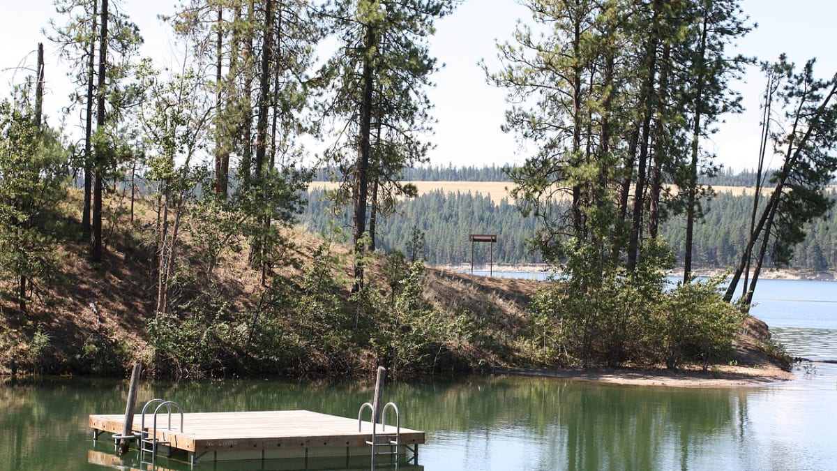
Lake Roosevelt National Recreation Area
Highway 174
Coulee Dam, WA
A 130-mile lake held behind the largest concrete dam in North America, winding through the wide-open Columbia country of eastern Washington.
Lake Roosevelt is what happens when you dam the mighty Columbia River: a long, narrow lake that reaches 130 miles up the old river canyon, from Grand Coulee Dam in the south nearly to the Canadian line in the north. It was born in 1941, when the dam, one of the largest concrete structures ever built, plugged the Columbia and the water rose behind it, and the National Park Service has looked after the shoreline as a national recreation area since 1946.
It is named for President Franklin Roosevelt, whose New Deal drove the dam's construction, and it is a place of huge scale and few crowds. This is deep, dry, open country, the sagebrush-and-basalt heart of eastern Washington, where the Columbia has drawn people for more than nine thousand years, and the lake offers a rare thing in a busy region: room to disappear onto the water for days.
What Travelers Love
- A vast, uncrowded 130-mile lake for boating, houseboating, paddling, and swimming
- Grand Coulee Dam, the largest concrete structure in North America, with a summer laser light show
- Historic Fort Spokane and old St. Paul's Mission on the shore, telling the human story of the river
- Bighorn sheep, moose, and mule deer along the banks, and long dark skies at night
Worth Knowing
- The lake is huge and remote; distances between launches and services are long, so plan fuel and supplies
- Water levels rise and fall with dam operations, so beaches and ramps can change through the season
- It is managed by the National Park Service with the Colville and Spokane Tribes; check any tribal-land access rules
- Summer is warm and dry and prime for the water; the dam's laser show runs on summer nights
Learn about Lake Roosevelt National Recreation Area
Damming the Columbia
Grand Coulee Dam was the great engineering ambition of the New Deal, a colossal wall of concrete flung across the Columbia River and completed in 1941 to generate hydroelectric power and irrigate the dry Columbia Basin. It is still the largest concrete structure in North America and one of the biggest power producers in the country, a monument to the era when America believed it could remake its rivers wholesale.
As the dam rose, the Columbia backed up for 130 miles into a slender lake named for the president who championed the project, Franklin Delano Roosevelt. The Park Service took over management of the new shoreline in 1946, turning it into a national recreation area. The reservoir also flooded ancestral lands and the traditional fisheries of the Colville and Spokane peoples, a loss that remains part of the honest story of the place.
History along the shore
The Columbia has drawn people to its banks for more than nine thousand years, and the lake preserves reminders of that long human presence. Near where the Spokane River joins the Columbia stands Fort Spokane, an 1880s U.S. Army post whose brick buildings later served as an Indian boarding school and hospital, now interpreted by the Park Service as a window onto a difficult chapter of Western history.
Not far off is old St. Paul's Mission, a small log Catholic mission that speaks to the missionary and fur-trade era on the upper Columbia. Together these sites give a shoreline that could be only about water and recreation a real depth of memory, from the Plateau peoples who fished these rapids for millennia to the soldiers, priests, and traders who followed.
A lake big enough to get lost on
At 130 miles long, Lake Roosevelt is built for the slow, immersive kind of trip. Houseboating is a signature here: rent a floating cabin and drift for days among quiet coves, gravel beaches, and side-canyon confluences, with hardly another soul in sight. There is also fishing for kokanee, rainbow trout, walleye, and sturgeon, kept up by hatcheries that release hundreds of thousands of fish into the lake each year.
Wildlife shares the banks, with bighorn sheep on the basalt slopes, moose in the wetter draws, turkey and mule deer in the pines, and eagles overhead. Back at the dam, summer nights bring an unexpected spectacle: a free laser light show projected onto the vast face of Grand Coulee, a moving thirty-minute story of the river and its people splashed across the concrete.
Visiting Lake Roosevelt
The southern anchor of it all is the little town of Coulee Dam, at the foot of the dam itself, where the visitor center explains the engineering and the nightly laser show plays in summer. From there boat launches, campgrounds, and beaches are scattered up the long shoreline, with Fort Spokane a natural stop where the Spokane River comes in.
Because the lake is so big and so remote, planning matters: distances between marinas and services are long, and water levels shift with dam operations, so a beach or ramp you counted on may look different than expected. Parts of the shore lie within Colville and Spokane tribal lands, so mind any local access rules. Come in the warm, dry summer, carry what you need, and give Lake Roosevelt the unhurried days it was made for.
Closest Boutels
The closest Boutel™ stays, so you can turn this stop into an overnight. Each is a place we chose through independent editorial review, never a paid placement.
Details
Coulee Dam, WA
Frequently asked questions
What is Lake Roosevelt National Recreation Area?
Lake Roosevelt National Recreation Area, in eastern Washington, surrounds the vast reservoir formed by the Grand Coulee Dam on the Columbia River, a long lake stretching around one hundred fifty miles behind the dam nearly to the Canadian border. Offering hundreds of miles of shoreline, the recreation area is a premier destination for boating, houseboating, fishing, swimming, camping, and water recreation amid scenic river-and-canyon landscapes. Popular houseboat rentals let visitors explore the long lake in comfort. With its immense reservoir, extensive shoreline, boating, houseboating, and camping in a beautiful setting, Lake Roosevelt National Recreation Area offers outstanding water recreation in eastern Washington.
What can you do at Lake Roosevelt National Recreation Area?
You can boat, water ski, kayak, and paddle on the vast reservoir, rent a houseboat to cruise and stay on the long lake, fish for a variety of species, swim at the beaches, camp at the many campgrounds along the shoreline, and enjoy the scenic river-and-canyon landscape. The houseboating is a signature experience, letting visitors explore the immense lake at a relaxed pace. With its huge reservoir, boating, houseboating, fishing, swimming, and camping across hundreds of miles of shoreline, Lake Roosevelt National Recreation Area offers outstanding and versatile water recreation in eastern Washington.
What safety tips apply at Lake Roosevelt National Recreation Area?
On the water, always wear a life jacket while boating or paddling, be aware that the large reservoir can develop hazardous winds and waves, and watch for changing weather and boat traffic. When swimming, be mindful of cold water, currents, and drop-offs, and watch children closely. Houseboaters should follow all safety guidelines. Bring sun protection and water for the exposed setting. Being mindful of water safety, wind and weather on the large lake, and the sun ensures a safe and enjoyable visit to Lake Roosevelt National Recreation Area.
When is the best time to visit Lake Roosevelt National Recreation Area?
Late spring through early fall is the prime season for boating, houseboating, swimming, and camping in the warm weather, with summer the busiest and most popular time for water recreation, while spring and fall offer pleasant temperatures and fewer crowds for fishing and boating. Winter is cold and quiet. Houseboat rentals are most popular in summer. For water recreation and houseboating, aim for late spring through summer, and for quieter conditions, the shoulder seasons are ideal. The lake's vast water recreation makes it most rewarding in the warmer months at Lake Roosevelt National Recreation Area.
What is near Lake Roosevelt National Recreation Area?
Lake Roosevelt National Recreation Area stretches behind the Grand Coulee Dam in eastern Washington, near the Grand Coulee Dam and its visitor center, the town of Grand Coulee, Banks Lake and Steamboat Rock to the south, and the surrounding scablands and Columbia River country. That makes Lake Roosevelt National Recreation Area a premier water-recreation destination to combine with the Grand Coulee Dam, Banks Lake, and the other attractions of eastern Washington on a visit to the state.
Nearby
Grand Coulee Dam Overlook
27 miles away
The overlook and visitor center sit just off SR-155 on the west side of the dam near the town of Coulee Dam.

Grand Coulee Dam Visitor Center
27 miles away
This free federal visitor center sits at the base of Grand Coulee Dam, the largest concrete structure and biggest hydroelectric plant in the United States, nearly a mile long and holding three times t...
Banks Lake
35 miles away
A 27-mile reservoir filling the Ice-Age-carved Grand Coulee just south of Coulee Dam, guarded by the huge basalt butte of Steamboat Rock.