
Curecanti National Recreation Area
Curecanti National Recreation Area, Gunnison, CO
Gunnison, CO
Three reservoirs strung along the Gunnison River, where the Milky Way shows up twice on a still night, once in the sky and once on the water.
Curecanti National Recreation Area is a string of three reservoirs along the Gunnison River, set in the wide, high country of west-central Colorado. The lakes were created when dams went up on the river in the 1960s, and the largest of them, Blue Mesa Reservoir, is the biggest body of water in the whole state. Twenty miles long with nearly a hundred miles of shoreline, it fills a basin of sagebrush and mesa where the Rocky Mountains start to become plateau country.
The place draws people for the water and the sky in equal measure. Anglers come for lake trout and kokanee salmon, some of the finest fishing of its kind in the country. Boaters and paddlers come for the open reaches of Blue Mesa and the deep, quiet canyon lakes below it. And when the sun goes down, the same emptiness that keeps the lakes calm keeps the sky dark, so the stars pour out overhead and, on a still night, settle onto the water as a second Milky Way.
What Travelers Love
- Blue Mesa Reservoir, the largest body of water in Colorado, with miles of open blue against the mesas
- Some of the best lake trout and kokanee salmon fishing anywhere in the country
- Dark skies rated near the top of the stargazing scale, with the Milky Way reflected on calm water
- Boat tours and quiet paddling on the deeper canyon lakes below the dam
Worth Knowing
- This is high country, mostly above 7,500 feet, so weather changes fast and nights turn cold even in summer
- Motorized boats share Blue Mesa with paddlers, so it can get busy on warm weekends
- The three lakes are very different: Blue Mesa is wide and open, while Morrow Point and Crystal sit deep in the canyon
- Services thin out quickly away from Gunnison, so fuel up and pack food before heading out
Learn about Curecanti National Recreation Area
Three lakes on one river
Curecanti is not one lake but three, stepping down the Gunnison River one after another. Blue Mesa Reservoir is the top and by far the largest, a broad open lake of blue water ringed by mesas and sagebrush hills. Below the Blue Mesa Dam the river drops into a narrowing canyon, where two more reservoirs, Morrow Point and Crystal, fill the gorge with deep, still water walled in by rock.
The character of the water changes as you move down the chain. Blue Mesa is wide and windy, made for boats and big skies. Morrow Point and Crystal are canyon lakes, hemmed in tight, reached mostly by paddle or on a boat tour, and they feel like a different world entirely. The same river ties them all together, and the whole recreation area was set aside in 1965 when the dams were finished.
A famous fishery
Blue Mesa Reservoir is known across the country for its fishing. It holds one of the great lake trout fisheries in the United States, along with a strong run of kokanee salmon, a landlocked cousin of the sockeye that turns deep red in the fall. Anglers work the lake year-round, from open water in the warm months to fishing through the ice in winter.
The fishing is more than a pastime here; it shapes the rhythm of the place. Boats fan out across the reservoir in the morning, marinas hum through the season, and the fall kokanee run brings its own crowd. Even for people who never wet a line, the sight of the lake full of boats under the mesas is part of what Curecanti is.
A dark sky over open water
Curecanti is a certified Dark Sky Park, and the reason is simple: there is very little around it. Far from any city, the reservoirs sit under a sky rated near the darkest end of the stargazing scale, dark enough that the Milky Way, the glowing band of our own galaxy, stands out plainly overhead. Thousands of stars fill the space between the mesas.
What makes the sky here special is the water beneath it. On a calm, windless night the surface of the lake goes glassy and mirrors the sky, so the Milky Way appears twice at once, once arched overhead and once laid across the reservoir. Seeing the galaxy in the sky and on the water at the same time is a rare treat, and it is one Curecanti gives up on the right night.
Between the mountains and the canyon
Curecanti sits at a meeting point of two worlds. To the east rise the southern Rocky Mountains around Gunnison and Crested Butte, high peaks and alpine valleys. To the west the land opens into the mesas and deep canyons of the Colorado Plateau. The recreation area straddles that seam, which is part of why the country around it looks the way it does, part mountain, part high desert.
The most dramatic neighbor is right at the western edge. Below Blue Mesa Dam the Gunnison River plunges into the Black Canyon of the Gunnison, one of the steepest and narrowest canyons in North America, now a national park. Curecanti and the Black Canyon share that river and that dam, so a trip to one is easily a trip to both.
Closest Boutels
The closest Boutel™ stays, so you can turn this stop into an overnight. Each is a place we chose through independent editorial review, never a paid placement.
Details
Gunnison, CO
Frequently asked questions
What is Curecanti National Recreation Area?
Curecanti National Recreation Area, near Gunnison in western Colorado, is a series of reservoirs along the Gunnison River, centered on Blue Mesa Reservoir, the largest body of water in Colorado. Set amid scenic high-desert and canyon landscapes, the area is a popular destination for boating, world-class fishing, camping, hiking, and wildlife viewing, with dramatic scenery including striking rock formations. Named for a Ute chief, Curecanti offers extensive water recreation in a beautiful mountain and canyon setting, serving as a gateway to the nearby Black Canyon of the Gunnison. With its vast reservoir, fishing, boating, and scenery, Curecanti is a premier water-recreation destination in western Colorado.
What can you do at Curecanti National Recreation Area?
You can boat, sail, kayak, paddleboard, and fish on Blue Mesa Reservoir and the other lakes, which offer some of the best fishing in Colorado, camp at the many campgrounds, hike the trails, take a boat tour into the scenic Black Canyon area, watch for wildlife, and enjoy the beautiful reservoir and canyon scenery. The vast water and surrounding landscape offer abundant recreation. Fishing and boating are especially popular. With its large reservoirs, excellent fishing, boating, camping, and scenic beauty, Curecanti National Recreation Area offers a premier water-recreation and outdoor destination in western Colorado near Gunnison.
What safety tips apply at Curecanti National Recreation Area?
On the water, always wear a life jacket while boating or paddling, be especially aware that winds can pick up quickly on the large reservoir creating dangerous waves, and watch for changing weather, cold water, and boat traffic. When swimming or near the water, watch children closely. On the trails, carry water, use sun protection, and be prepared for the high elevation and possible storms. Being mindful of the sudden winds and waves on the reservoir, wearing a life jacket, and preparing for the weather and elevation keeps a visit to Curecanti safe and enjoyable.
When is the best time to visit Curecanti National Recreation Area?
Summer is the prime season for boating, fishing, swimming, and camping in the warm weather, though it is the busiest time, while late spring and early fall are pleasant and quieter, with fall offering good fishing and lovely weather. Winter is cold, with ice fishing possible on the frozen reservoir. For water recreation and warm-weather fun, aim for summer, and for fishing with fewer crowds, the shoulder seasons are ideal. The area's scenery and abundant water recreation make it rewarding throughout the warmer months near Gunnison in western Colorado.
What is near Curecanti National Recreation Area?
Curecanti National Recreation Area is near Gunnison in western Colorado, close to the dramatic Black Canyon of the Gunnison National Park just downstream, the town of Montrose to the west, the mountain town of Crested Butte to the north, and within reach of the San Juan Mountains and the region's scenery. That makes Curecanti National Recreation Area a premier water-recreation stop to combine with the Black Canyon of the Gunnison, Gunnison, Crested Butte, and the mountain attractions of western Colorado on a visit to the state.
Nearby
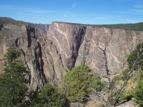
Black Canyon of the Gunnison National Park
20 miles away
A gorge so narrow and deep that parts of its walls get only 33 minutes of sunlight a day.

Gunnison Point
20 miles away
Gunnison Point is the classic first view of Black Canyon of the Gunnison, a short walk from the South Rim Visitor Center to a railed overlook poised above the sheer, shadowy gorge.

Chasm View
22 miles away
Chasm View is a vertigo-inducing overlook in Black Canyon of the Gunnison, a short walk to the rim where the canyon narrows to its most dramatic and the walls plunge more than 1,800 feet almost straig...

Painted Wall
22 miles away
The Painted Wall is the tallest cliff in Colorado, a sheer 2,250-foot rampart of dark rock streaked with pale pink bands of pegmatite that look like they were brushed on by hand.
San Juan Skyway
31 miles away
The San Juan Skyway (US-550, US-160, CO-62, CO-145) is a 236-mile loop through the San Juan Mountains, including the 25-mile Million Dollar Highway between Ouray and Silverton - a series of cliff-edge...

Monarch Pass
44 miles away
Monarch Pass carries US 50 over the Continental Divide at 11,312 feet, about 20 miles west of Salida, where the highway tops out above treeline with the peaks of the Sawatch Range stacking up in every...