
San Juan Skyway
Colorado
Some drives ask you to look at the mountains. The San Juan Skyway drops you right into the middle of them. This is a giant loop of pavement in the far southwest corner of Colorado, about 233 miles long, that ties together four highways and four grand old mining towns as it climbs over one high pass after another. In a single day you can roll through red rock desert near Cortez, wind up into deep spruce forest, and top out on a windswept pass above the treeline where the peaks stand higher than 13,000 feet on every side.
The federal government singled out this loop as one of the finest roads in the country and named it an All-American Road, the highest honor in the national scenic byway system. The most famous stretch, the section between Silverton and Ouray, is known as the Million Dollar Highway, a narrow cliff-hugging climb of hairpin turns that many travelers count among the most thrilling drives in America. Whether you take the whole loop or just one leg of it, the Skyway is less a way to get somewhere and more a destination all its own.
Learn about San Juan Skyway
The Road
The San Juan Skyway is a loop, not a straight line, so you can start anywhere along it and end up back where you began. It stitches together four highways: US-550 up the eastern side, US-160 across the south, and CO-145 and CO-62 down and across the west. All told it runs about 233 miles and can be driven in roughly six hours without stops, though almost nobody drives it that fast. Between the passes, the overlooks, and the historic towns, most people give it a long, full day or turn it into an overnight trip.
What sets the Skyway apart is elevation. The loop crosses several high mountain passes, and a few of them, including Red Mountain Pass at about 11,000 feet, sit well above the treeline where the air is thin and the views are enormous. On the way up you pass through forests of aspen and spruce, past old mine tailings and waterfalls, with jagged peaks filling the windshield at nearly every turn. The road is fully paved the whole way around, so an ordinary car handles the loop just fine in good weather.
The most talked-about piece of the loop is the 25-mile stretch of US-550 between Silverton and Ouray, the Million Dollar Highway. It climbs over Red Mountain Pass in a series of tight switchbacks carved into the mountainside, and in places the outer edge drops away steeply with no guardrail between the pavement and the canyon below. It is a slow, careful, deeply memorable drive. Take your time, use the pullouts to soak in the view rather than gawking from behind the wheel, and let faster traffic go by.
How to Get There
Most travelers begin the loop in Durango, the largest town on the route and an easy base with its own regional airport. Coming from Denver, the simplest approach is to drive south and west across the state on US-285 and US-160, a long but scenic haul of roughly six to seven hours that delivers you straight to Durango. From there you can pick up the Skyway heading north on US-550.
Coming from the south, out of New Mexico, take US-550 north from Bernalillo near Albuquerque, or follow US-160 west from the Pagosa Springs area, and you will reach Durango in a few hours. From the west, travelers driving in from Utah or the Four Corners area come in on US-160 through Cortez, which puts you near Mesa Verde National Park and the western side of the loop first.
Because it is a loop, direction is a matter of taste. Many people drive it clockwise, heading north out of Durango on US-550 to hit the dramatic Million Dollar Highway early, then continuing through Ouray and Ridgway to Telluride before curving back south through Rico and Dolores to Durango. Others go counterclockwise to save the biggest passes for the end. Either way you see the same country, just in a different order.
History
The San Juan Skyway follows roads born out of Colorado's silver and gold rush. In the 1870s and 1880s, prospectors poured into the San Juan Mountains and threw up mining camps in places that seemed almost impossible to reach, wedged into box canyons and perched on high shelves of rock. Towns like Silverton, Ouray, and Telluride sprang up almost overnight, and they needed roads to haul ore out and supplies in.
The Million Dollar Highway stretch between Ouray and Silverton grew from a rough toll road built in the 1880s by Otto Mears, a pioneering road and railroad builder known as the Pathfinder of the San Juans. His crews blasted a route through terrain so steep that no easy path existed. Over the following decades the road was widened, rerouted, and paved into the modern US-550 that travelers drive today, though it still follows much the same daring line across the cliffs. The name Million Dollar Highway has several competing origin stories, from the cost of building it to a claim that the roadbed fill contained valuable ore, and locals happily argue over which is true.
The full loop was formally recognized as the San Juan Skyway Scenic Byway by the state of Colorado in 1989, and the U.S. Forest Service designated it a National Forest Scenic Byway around the same time. Its national moment came in 1996, when the Federal Highway Administration named it an All-American Road, the top tier of the country's scenic byway program, reserved for routes considered a destination in their own right. Only a small number of roads nationwide hold that honor.
Today the mining that built these towns has mostly given way to tourism, but the history is everywhere you look. Victorian storefronts still line the main streets, narrow-gauge steam trains still run out of Durango and Silverton just as they did in the 1880s, and old mine works cling to the slopes above the road. The Skyway is, in a real sense, a drive through a living museum of the mountain West.
Little-Known Facts
- The San Juan Skyway was named an All-American Road, the highest honor in the national scenic byway system, in 1996. It was Colorado's first road to earn that distinction.
- The famous Million Dollar Highway between Ouray and Silverton grew from an 1880s toll road built by Otto Mears, a road and railroad builder nicknamed the Pathfinder of the San Juans.
- Nobody agrees on how the Million Dollar Highway got its name. The stories range from the cost of building it, to the value of the view, to a claim that the roadbed gravel was full of gold-bearing ore.
- Ouray is nicknamed the Switzerland of America for its dramatic setting, walled in on nearly every side by peaks that rise more than 13,000 feet.
- The loop crosses several high mountain passes, and parts of Red Mountain Pass sit above the treeline at around 11,000 feet, where trees can no longer grow because the air is too thin and cold.
- The red rock and rust-colored soil around Red Mountain Pass get their color from iron in the ground, a visible reminder of the mineral riches that first drew miners here.
- A coal-fired narrow-gauge steam train has run between Durango and Silverton since 1882, following the Animas River gorge on tracks blasted into canyon walls that no road parallels.
- In fall, the aspen forests along the Skyway turn brilliant gold, and the loop becomes one of the most celebrated leaf-peeping drives in the entire country.
Along the Route
Durango
Durango is the largest town on the loop and the most common place to begin, a lively Victorian mountain town where the Animas River runs right through downtown. A block from the water sits the depot for the coal-fired narrow-gauge steam train that has climbed the Animas gorge to Silverton since the 1880s. With its regional airport, riverside trail, and historic main street, Durango makes an easy base for tackling the Skyway.
Durango and Silverton Narrow Gauge Railroad
This coal-fired steam train has run the same route since 1882, covering the miles between Durango and Silverton through the Animas River Canyon. The track was blasted into vertical canyon walls with no road running alongside for most of the way, so the ride reaches scenery you cannot see from the Skyway itself. It is one of the great engineering feats in Colorado and a favorite way to experience the mountains without driving them.
Coal Bank Pass
Heading north out of Durango on US-550, the road climbs to Coal Bank Pass at about 10,600 feet, the first of the big summits on the eastern leg. A pullout at the top opens up sweeping views across forested ridges toward the high peaks ahead. It is a good spot to stretch your legs and feel the thinner mountain air before the road climbs even higher.
Molas Pass Overlook
At nearly 10,900 feet on US-550, Molas Pass has a large free pullout with a wide-open view of the Needle Mountains and the Weminuche Wilderness. Look down into the Animas River gorge far below, where on clear days you can spot smoke rising from the steam train thousands of feet beneath you. No hiking is needed to enjoy the view, and midsummer brings wildflowers across the foreground.
Silverton
Silverton is a frozen-in-time mining town high in the San Juans, where the steam train still pulls in and the peaks rise straight from the end of Main Street. Its wide dirt side streets and false-front buildings look much as they did in the silver-boom days. It marks the southern end of the Million Dollar Highway, so it is a natural place to pause, fuel up, and get ready for the most dramatic stretch of the loop.
Red Mountain Pass
Red Mountain Pass tops out at about 11,000 feet and is the high point of the Million Dollar Highway between Silverton and Ouray. The rust-red slopes all around take their color from iron in the rock, a reminder of the mining that built these towns. This is the wildest part of the drive, a series of tight switchbacks with steep drops and long views, so go slow, use the pullouts, and drink it in.
Ouray
Ouray is a small Victorian mining town wedged into the head of a box canyon, walled in on nearly every side by soaring peaks. Its dramatic setting earned it the nickname the Switzerland of America. Waterfalls tumble from the surrounding cliffs, hot springs bubble up at the valley floor, and the Million Dollar Highway climbs spectacularly out of town to the south. It is one of the most beloved stops on the entire loop.
Ridgway State Park Overlook
A few miles north of Ridgway on US-550, a short paved and wheelchair-accessible path drops from the visitor center to an overlook above Ridgway Reservoir, with the jagged San Juans stacked up behind the blue water. It is one of the great quick views on the drive, only a few minutes on foot from the lot. Mounted scopes let you pull in the peaks and, at times, ospreys or eagles working the water.
Telluride
Reached by a short spur off CO-145, Telluride sits at the end of a stunning box canyon ringed by 13,000-foot peaks and laced with waterfalls, including the tall cascade of Bridal Veil Falls at the head of the valley. A former silver-mining town turned famous mountain resort, it keeps its historic main street and small-town feel. The side trip in and back is well worth the extra miles for one of the most jaw-dropping settings in Colorado.
Lizard Head Pass
South of Telluride on CO-145, the Skyway climbs over Lizard Head Pass at about 10,200 feet, named for the distinctive rock spire of Lizard Head Peak nearby. The pass opens onto broad alpine meadows framed by high peaks, a gentler kind of grandeur than the cliff-edge drama farther east. It is a fine place to pull over, breathe the mountain air, and take in the wide views.
Rico
Rico is a tiny former mining town along CO-145 in the Dolores River valley, a quiet remnant of the boom days tucked deep in the mountains. Blink and you could miss it, but it makes a peaceful pause between the high passes and the desert country to the southwest. The forested river valley here feels a world away from the busy resort towns.
Dolores
As the Skyway drops out of the mountains along CO-145, it reaches Dolores, a small town on the Dolores River near the edge of red rock country. This marks the transition from high alpine forest to the drier desert landscape of the southwest corner of the state. It also puts you within easy reach of Mesa Verde before the loop closes back toward Durango on US-160.
Mesa Verde National Park
Just off US-160 on the southwestern side of the loop, Mesa Verde National Park protects some of the best-preserved Ancestral Puebloan cliff dwellings in North America, built into canyon alcoves and left behind around 1300 AD. Ranger-led tours of sites like Cliff Palace let visitors walk through the ancient stone rooms and climb the original hand-and-toe holds. It is an easy and rewarding detour that adds deep human history to a drive otherwise defined by mountains.
Details
San Juan Mountains, southwest Colorado
Frequently asked questions
When was the San Juan Skyway designated an All-American Road?
The Federal Highway Administration named the San Juan Skyway an All-American Road in 1996, the highest honor in the national scenic byway system. It was recognized earlier, in 1989, as a Colorado Scenic Byway and a U.S. Forest Service Scenic Byway. The All-American Road designation is reserved for routes considered a destination in their own right, and the Skyway was the first road in Colorado to earn it.
How long is the San Juan Skyway, and how long does it take to drive?
The San Juan Skyway is a loop of about 233 miles through the San Juan Mountains, linking US-550, US-160, CO-145, and CO-62. Driven straight through without stops it takes roughly six hours, but almost nobody drives it that way. With the passes, overlooks, and historic towns to explore, most travelers give it a full day or turn it into an overnight trip.
What are the must-see stops along the San Juan Skyway?
The highlights include the four historic mining towns of Durango, Silverton, Ouray, and Telluride, plus the dramatic Million Dollar Highway stretch over Red Mountain Pass. High-country overlooks at Molas Pass, Coal Bank Pass, and Lizard Head Pass offer huge mountain views with little or no walking. Mesa Verde National Park, just off the southwestern leg on US-160, adds ancient cliff dwellings to the drive.
Is the San Juan Skyway free to drive?
Yes. The San Juan Skyway follows public highways, so driving the loop itself is free. Some attractions along the way charge admission, such as Mesa Verde National Park and the Durango and Silverton steam train, and certain trailheads or recreation areas may have parking or use fees. The road, though, costs nothing to drive.
What is the best time of year to drive the San Juan Skyway?
Summer and early fall are the prime seasons, when all the high passes are clear and the towns are lively. Late September into early October is especially prized, because the aspen forests turn brilliant gold and the loop becomes one of the most famous fall-color drives in the country. Early morning and the hours near sunset bring the softest light on the peaks.
Is the San Juan Skyway open year-round?
The loop is generally open all year, since the highways that make it up are kept plowed through winter. That said, the high passes, especially the Million Dollar Highway over Red Mountain Pass, can close temporarily after heavy snowstorms or during avalanche control work. In winter, always check current road conditions before you set out, and be ready to change your plans if a pass is closed.
Do you need four-wheel drive to drive the San Juan Skyway?
No. The main Skyway loop is fully paved, and an ordinary passenger car handles it well in good weather. Four-wheel drive and high clearance are only needed for the many rough backcountry and old mining roads that branch off the loop, such as the routes to alpine lakes and ghost towns. For the paved Skyway itself, a regular car is fine.
What are the winter driving conditions like on the San Juan Skyway?
Winter driving on the Skyway is serious business. The high passes get deep snow, ice, and strong wind, and the Million Dollar Highway in particular is steep, narrow, and prone to closures after storms or for avalanche control. If you drive it in winter, use a vehicle suited to snowy mountain roads, carry chains or proper snow tires, go slowly, and check road conditions before every leg. When in doubt, wait for the weather to clear.
Are there gas stations and services along the San Juan Skyway?
Yes, but the towns are spaced out, so plan ahead. Durango, Silverton, Ouray, Ridgway, Telluride, and Cortez all have fuel, food, and lodging, but long mountain stretches run between them with no services at all. It is smart to top off your tank in a town before a big climb rather than counting on finding gas near a high pass.
How high is the San Juan Skyway, and will the altitude affect me?
The loop crosses several passes above 10,000 feet, and Red Mountain Pass reaches about 11,000 feet, high enough that the air is noticeably thinner than at sea level. Some visitors feel lightheaded, short of breath, or tired at these elevations, especially if they arrived recently from lower ground. Take it easy, drink plenty of water, and give yourself time to adjust. If anyone feels unwell, the simple fix is to descend to a lower elevation.
Nearby
San Juan Skyway
0.0 miles away
The San Juan Skyway (US-550, US-160, CO-62, CO-145) is a 236-mile loop through the San Juan Mountains, including the 25-mile Million Dollar Highway between Ouray and Silverton - a series of cliff-edge...
Molas Pass Overlook
3.6 miles away
Molas Pass at 10,899 feet on US-550 between Durango and Silverton has a large free pullout area on the north side of the summit with panoramic views of the Needle Mountains and the Weminuche Wildernes...
Coal Bank Pass Summit
3.7 miles away
Coal Bank Pass at 10,640 feet on US-550 between Durango and Silverton has a signed summit parking area with views south toward the La Plata Mountains and north toward the Needle Mountains.

Silverton
7.4 miles away
A frozen-in-time mining town high in the San Juans, where a steam train still pulls in and the peaks rise straight from the end of Main Street.

Mesa Verde National Park
52 miles away
Cliff dwellings built into canyon walls by Ancestral Puebloans more than seven centuries ago.
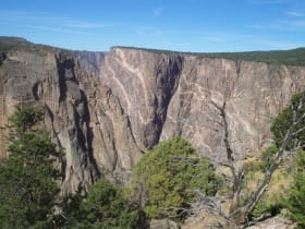
Black Canyon of the Gunnison National Park
57 miles away
A gorge so narrow and deep that parts of its walls get only 33 minutes of sunlight a day.