
Black Canyon of the Gunnison National Park
South Rim Visitor Center, Black Canyon of the Gunnison National Park, CO
Montrose, Western Colorado
Some canyons are wide and sunny and welcome you in. Black Canyon of the Gunnison is not one of them. It is a narrow, dizzying slot cut straight down through some of the oldest rock on the continent, so deep and so tight that in places the walls stand more than half a mile apart at the top and only a stone's throw apart at the bottom. The rock is dark, ancient, and streaked with pale veins, and much of the gorge stays in shadow through the day. That is where the name comes from: parts of these walls are so steep and so close together that the sun barely reaches them, and the depths look nearly black.
This is a national park, protected first as a national monument in 1933 and raised to national park status in 1999. Far below, the Gunnison River still roars through the bottom, dropping faster here than almost any river in the country and grinding the canyon deeper a grain at a time. Two rims look out over it. The South Rim is the developed, main side, with a paved road and a string of overlooks. The North Rim is remote and quiet, reached by a different route entirely. However you come at it, the first look over the edge tends to make you step back.
Learn about Black Canyon of the Gunnison National Park
The Park
Black Canyon drops about 2,722 feet from rim to river, and it does it in a hurry. This is one of the steepest, narrowest canyon systems in North America. At its tightest point the gorge is only about 40 feet wide down at the bottom, hemmed in by walls that shoot almost straight up. The rock is Precambrian, some of the oldest exposed stone anywhere, nearly two billion years old, and it is so hard that the river could only carve down, not out. That is why the canyon is a slot instead of a bowl.
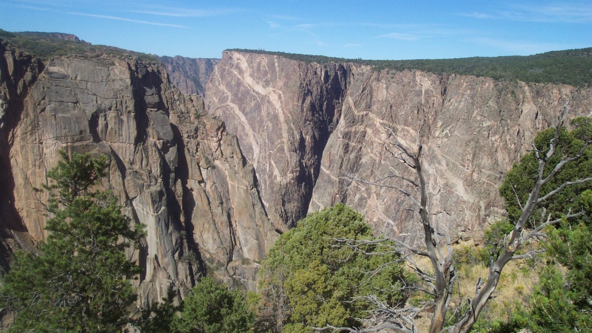
The signature sight is the Painted Wall, the tallest cliff face in all of Colorado at about 2,250 feet, which is taller than the tallest skyscrapers in the country. Its dark cliff is laced with light-colored streaks of a pinkish rock called pegmatite, which squeezed up into cracks in the old stone long ago and hardened there, so the wall looks brushed with pale paint. The walls stand so sheer and so close that at the winter solstice the narrowest stretch of the canyon floor gets only about 33 minutes of direct sunlight a day.
Above the gorge the land is high, dry mesa country of pinyon pine, juniper, sagebrush, and oak brush, quiet and open. The two rims never touch. The South Rim, reached from US-50 near the town of Montrose, is the developed side, with the visitor center, the paved rim road, and a dozen overlooks that each frame a different slice of the drop. The North Rim, reached on a different and much rougher road, is remote and lightly visited, prized by those who want the canyon nearly to themselves.
How to Enter
- South Rim Entrance, off US-50 and CO-347 near Montrose, is the main way in. It leads to the South Rim Visitor Center, the paved rim road, and the twelve South Rim overlooks. It is open year-round, though the rim road is plowed only partway in winter and full access depends on the snow.
- North Rim Entrance, off CO-92 near the town of Crawford, is remote and seasonal. The last several miles of the approach are unpaved gravel, and the North Rim road closes for the winter, generally open only from around May into November. The two rims are not connected inside the park, so reaching one from the other means a long drive around.
- Most visitors come through the South Rim from Montrose, which sits about 15 miles west on US-50. From the Denver area, the drive crosses the mountains on US-50 over Monarch Pass. From Grand Junction to the northwest, follow US-50 south and east to Montrose, then CO-347 up to the rim.
Things to Do
- Painted Wall View is the most dramatic of the twelve South Rim overlooks, looking straight across at Colorado's tallest cliff with its pale streaks of pegmatite. It is the picture most people come for.
- Dragon Point is the southernmost overlook, gazing down the length of the canyon toward the river far below and back at the Painted Wall from a different angle.
- The South Rim Road strings a dozen overlooks along the edge, each a short walk from the pullout, so you can take in the whole canyon a viewpoint at a time without any hard hiking.
- Curecanti National Recreation Area, about 15 miles east along US-50, spreads out along Blue Mesa Reservoir, the largest body of water in Colorado, with fishing, boating, and calm open shoreline that feels worlds apart from the gorge.
- Montrose, the gateway city 15 miles west, has full services and the Museum of the Mountain West, an open-air collection of restored frontier buildings that tells the story of the region.
History
The Ute people are the original inhabitants of this high mesa and canyon country, and their connection to it runs deep and continues today. For generations the Utes traveled and lived across these lands, hunting the mesas and drawing on the rivers, and the canyon has long been part of their homeland. The park stands on that homeland, and its story properly begins with them, long before any road reached the rim.
To newcomers the Black Canyon was for a long time simply impassable, too sheer and too narrow to cross or to farm. That changed in 1901, when two men, William Torrence and Abraham Lincoln Fellows, floated and scrambled through the inner gorge on a hard, dangerous journey to see whether its water could be tapped for irrigation. Their trip led to the Gunnison Tunnel, a nearly six-mile passage bored through the canyon wall to carry river water out to the dry farmland of the Uncompahgre Valley, finished in 1909 and a marvel of its day.
The most spectacular stretch of the gorge was set aside as Black Canyon of the Gunnison National Monument in 1933, and in the 1930s the Civilian Conservation Corps went to work here, building rim roads and overlooks and much of the early park infrastructure that opened the South Rim to visitors. For decades it remained a monument, a lesser-known Colorado wonder.
In 1999 Congress redesignated the area as Black Canyon of the Gunnison National Park, recognizing that a canyon this deep, this narrow, and this old belonged among the country's great protected places. Today it draws far fewer crowds than Colorado's mountain parks, which is part of its quiet appeal, and it protects not only the gorge but some of the darkest night skies in the state.
Little-Known Facts
- The rock in the canyon walls is Precambrian gneiss and schist, nearly two billion years old, some of the oldest exposed rock in North America. It was so hard that the river could only cut straight down.
- The Painted Wall is Colorado's tallest cliff at about 2,250 feet, taller than the tallest building in the United States. Its pale streaks are pegmatite, a lighter rock that oozed up into cracks in the dark stone and hardened.
- At its narrowest, the canyon floor is only about 40 feet across, while the rims can stand more than a thousand feet apart above it, which is why it counts among the narrowest deep canyons anywhere.
- The Gunnison River drops faster through this canyon than nearly any river in the country, falling an average of about 96 feet per mile, and in one stretch it plunges much more steeply still.
- At the winter solstice, the deepest, narrowest part of the canyon floor receives only about 33 minutes of direct sunlight in an entire day.
- The park is an International Dark Sky Park, and on a clear, moonless night the Milky Way arches overhead in a way most people rarely get to see.
- The Gunnison Tunnel, finished in 1909 to divert river water for irrigation, was one of the longest irrigation tunnels in the world at the time and is still in use today.
- The inner canyon has no maintained trails. The routes down are steep, unmarked scrambles that only experienced, permitted hikers should attempt.
Plan Your Visit
- An entrance fee applies (per vehicle, good for seven days), and interagency annual passes are accepted; check the park website for current rates.
- The South Rim has a paved road, twelve overlooks, and a visitor center open year-round, though the rim road is plowed only partway in winter.
- The North Rim is the quiet side: the last few miles of the road are unpaved gravel, and it is generally open only from around May into November, closing for the winter.
- The inner canyon and its routes down to the river, including the Gunnison Route, are unmaintained and technical, and require a free wilderness permit plus real gear and experience.
- Montrose sits about 15 miles west of the South Rim on US-50 and has full services, fuel, and lodging, so it makes an easy base.
Inside the Park
Gunnison Point
The classic first view, a short walk from the South Rim Visitor Center above the shadowy gorge.
Chasm View
A vertigo-inducing overlook where the canyon narrows and the walls drop over 1,800 feet to the river.
Painted Wall
The tallest cliff in Colorado, a sheer 2,250-foot wall streaked with pink, seen from the South Rim Drive.
Warner Point
A short nature trail to the highest overlook at the quiet west end of the rim, with sweeping mountain views.
Details
Montrose, Western Colorado
Frequently asked questions
Is there an entrance fee?
Yes. Black Canyon of the Gunnison charges a per-vehicle entrance fee that is good for seven days, and interagency annual passes are accepted. Check the National Park Service website for the current rate before you go.
What is the difference between the South Rim and the North Rim?
The South Rim, reached from US-50 near Montrose, is the developed, main side of the park, with a paved road, a visitor center open year-round, and a dozen overlooks. The North Rim is remote and quiet, reached by a completely different route near Crawford. The last several miles of the North Rim road are unpaved gravel, and it closes for the winter, generally open only from around May into November.
Can you drive from the South Rim to the North Rim inside the park?
No. The two rims are not connected inside the park. To get from one to the other you have to drive a long way around, roughly two to three hours by road. Most visitors pick one rim for their trip, and the South Rim is the easier and more developed choice.
How safe are the overlooks, and are they good for kids?
The overlooks sit at the edge of sheer dropoffs that fall thousands of feet, and in many spots the rock ends without a wide margin. Stay well back from the edge, keep to the marked viewpoints and railings where they exist, and hold small children by the hand at all times. The views are worth the trip, but this is a place to be careful and deliberate.
Can you hike down into the canyon to the river?
Only if you are experienced and prepared, and it is not for most visitors. The inner-canyon routes, including the Gunnison Route, are unmaintained, unmarked, and extremely steep, more scramble than trail, with loose rock and long, punishing climbs back out. They require a free wilderness permit and real gear and skill. If you are not a seasoned route-finder in rugged terrain, enjoy the canyon from the rim instead.
When is the best time of year to visit?
Late spring through early fall is the reliable window, roughly May into October, when both rims and their roads are open and the weather is mild. Summer days can be hot on the exposed mesa, and late spring and early fall bring cooler air and thinner crowds. Winter is quiet and beautiful on the South Rim, but the rim road is plowed only partway and the North Rim is closed.
How much time do you need?
You can drive the South Rim road, stop at the main overlooks, and take in the canyon in a half day. Give it a full day if you want to walk out to every viewpoint, linger at the Painted Wall, and add a side trip to Curecanti and Blue Mesa Reservoir nearby. Serious inner-canyon hikers should plan much more and come fully prepared.
What is the must-see stop?
Painted Wall View, on the South Rim, is the one not to miss. It looks straight across at the Painted Wall, Colorado's tallest cliff at about 2,250 feet, streaked with pale veins of pegmatite. Dragon Point, the southernmost overlook, is a close second for its long view down the canyon toward the river.
How good is the stargazing?
It is superb. Black Canyon of the Gunnison is a certified International Dark Sky Park, far from big-city lights, so on a clear, moonless night the Milky Way arches overhead in a way most people rarely get to see. The park sometimes hosts astronomy programs in the warmer months, and simply looking up from a South Rim overlook after dark can be unforgettable. Bring a red flashlight to protect your night vision and dress warm, since the high country cools off fast after sunset.
Are pets allowed, and is there lodging in the park?
Pets are allowed in developed areas, parking lots, and along roads, but not on trails or below the rim, so plan around that. For lodging, the park has campgrounds on both rims but no hotel or lodge inside it. The town of Montrose, about 15 miles west of the South Rim, is the practical base for rooms, fuel, and full services.