

Big Rock Candy Mountain
3455 Forest Rd 474, Sevier, UT
Marysvale, UT
A hillside splashed in yellows and oranges along the Sevier River, named for a beloved old folk song about a hobo's paradise where the sun shines every day.
Big Rock Candy Mountain is a hillside so vividly colored it hardly looks real, streaked with bands of bright yellow, orange, and cream that stand out against the greens and grays of the surrounding mountains. It rises beside the Sevier River in a canyon on the scenic U.S. 89 corridor, a splash of color that has made it a landmark on the drive through central Utah for a century.
The mountain owes its fame partly to a song. The classic American folk tune Big Rock Candy Mountain, a hobo's daydream of a land of easy living, gave the hill its name and a lasting place in popular imagination. Today a small river resort sits across from it, and the Sevier River, a rail trail, and the famous Paiute ATV Trail make the canyon a hub for easygoing outdoor fun.
What Travelers Love
- The startling bands of yellow, orange, and cream that color the whole mountainside
- The connection to the classic hobo folk song of the same name
- Floating or fishing the Sevier River that runs right below the mountain
- The Paiute ATV Trail and rail-trail routes that pass through the canyon
Worth Knowing
- The colors are the mountain's whole attraction, best seen from the highway pullout and river resort across from it
- This is a scenic stop rather than a hiking destination, though nearby trails and the river offer more to do
- The area is high country, so weather can turn cool and stormy, and winter brings snow
- It sits along a popular ATV and byway corridor, so summer weekends can be busy
Learn about Big Rock Candy Mountain
Why the mountain is so colorful
The mountain's brilliant colors come from ancient volcanic rock that has been chemically altered by hot, mineral-rich waters, a process called hydrothermal alteration. Long ago, heated fluids moving through the rock reacted with it and stained it with iron oxides and clay minerals, painting the hillside in yellows, oranges, and reds that weathering has since laid bare.
For all the sweetness the name suggests, the rock is not candy but a striking example of what mineral chemistry can do to a mountainside. The bright, crumbly slopes are best appreciated from a distance, from the highway pullout or the resort across the river, where the full sweep of color reads at once against the darker mountains behind.
The song and the legend
The mountain shares its name with one of the most beloved American folk songs, a Depression-era hobo ballad most famously recorded by Harry McClintock, describing a paradise for wanderers where hens lay soft-boiled eggs, the lemonade springs flow, and the sun shines every day. The song became a standard, carried down through generations and introduced to new audiences in film and on record.
A local story tells that a resort owner in the canyon leaned into the connection, naming his stop after the song and even dubbing the little spring nearby Lemonade Springs after a line in the lyrics. Whether the mountain named the song or the song named the mountain, the two have been intertwined ever since, giving this colorful hillside a place in American music history.
The river, the trail, and the town
The Sevier River runs right below the mountain, offering easy fishing and gentle floating, and a resort across from the hill rents tubes and gear for a lazy afternoon on the water. An old rail line through the canyon has become a rail trail for walking and biking, tracing the river past the colored slopes.
The canyon is also a gateway to the Paiute ATV Trail, one of the largest off-highway trail systems in the country, which loops through the mountains of central Utah and draws riders to Marysvale as a base. The nearby town, once a mining community, still carries traces of that boom-and-bust history in the hills around it.
The land and its first people
This stretch of the Sevier River country lies within the ancestral homeland of the Paiute people, whose bands lived, hunted, and gathered across south-central Utah for generations before settlers arrived. The Paiute remain in the region today, and the great ATV trail through these mountains carries their name.
The canyon sits at a scenic crossroads, along the byway that links the high central Utah plateaus with the red-rock parks to the south. In summer the slopes are green around the bright mountain, fall brings color to the aspens and cottonwoods, and winter dusts the whole scene with snow, the yellow rock glowing against the white.
Closest Boutels
The closest Boutel™ stays, so you can turn this stop into an overnight. Each is a place we chose through independent editorial review, never a paid placement.
Details
Marysvale, UT
Frequently asked questions
What is Big Rock Candy Mountain?
Big Rock Candy Mountain is a colorful yellow-and-orange hill rising along US-89 in Marysvale Canyon in central Utah, named after the classic old folk song about a hobo's paradise. Its unusual hues come from volcanic rock altered by ancient hot springs and minerals. More a quirky, nostalgic roadside landmark and small recreation area than a hiking destination, it sits beside the Sevier River and makes a fun, offbeat stop on a central Utah road trip.
Why is it called Big Rock Candy Mountain?
The mountain takes its name from the famous early-twentieth-century folk and hobo song Big Rock Candy Mountain, which describes an imaginary land of ease and plenty. The brightly colored Utah hill, with its sweet-sounding name, became associated with the tune, and it has embraced the connection ever since, complete with a roadside resort playing up the theme. That blend of natural oddity and Americana nostalgia is a big part of its charm as a stop.
What can you do at Big Rock Candy Mountain?
Beyond admiring and photographing the oddly colored mountain, you can stop at the Big Rock Candy Mountain resort area, raft or tube the Sevier River in the warmer months, and access the sprawling Paiute ATV Trail system, one of the largest off-highway trail networks in the country. It is a lighthearted, recreation-focused stop rather than a sightseeing hike, offering a nice break and some river and trail fun along the highway.
When is the best time to visit Big Rock Candy Mountain?
Spring through fall is best for enjoying the river rafting and tubing and the ATV trails, while the colorful mountain itself makes a quick photo stop any time of year. Summer is prime for water activities on the Sevier River, and fall adds pleasant temperatures and color to the drive. As a roadside landmark and recreation area, it is easy to fold into a trip through central Utah whenever you pass by.
What is near Big Rock Candy Mountain?
It sits along the US-89 corridor near Marysvale in central Utah, close to Fremont Indian State Park, with its ancient rock art and pit-house history, and within the broader Sevier River region. The route makes a scenic connector between Interstate 70 and the southern Utah parks like Bryce Canyon and Capitol Reef. That makes Big Rock Candy Mountain a fun, quirky stop to break up a longer drive through the region.
Nearby

Fremont Indian State Park
7.5 miles away
Fremont Indian State Park preserves the site of Five Fingers village, the largest Fremont culture community ever excavated. When I-70 was being built in 1983, workers uncovered the site.
Cove Fort Historic Site
17 miles away
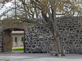
Cove Fort was built in 1867 under the direction of Brigham Young as a way station between settlements in the Sevier Valley and Beaver to the south.
Pando
28 miles away
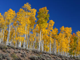
Pando, Latin for "I spread," is a grove of quaking aspen (Populus tremuloides) near Fish Lake in which all individual trunks share a single underground root system.

UT-12 Scenic Byway
50 miles away
Utah Highway 12 runs 124 miles from US-89 near Panguitch to Torrey near Capitol Reef, crossing five distinct geological formations and three national park corridors.

Capitol Reef National Park
57 miles away
A hundred-mile wrinkle in the earth called the Waterpocket Fold, plus historic orchards you can still pick from.

Bryce Canyon National Park
60 miles away
The largest concentration of hoodoos on Earth, a natural amphitheater of orange and pink stone spires.