
Beartooth Highway
Montana & Wyoming
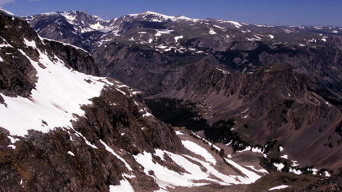
Some drives ease you into the mountains. The Beartooth Highway hurls you at them. Leaving the old coal town of Red Lodge, Montana, U.S. Route 212 stops pretending to be an ordinary road and starts climbing in tight, stacked switchbacks up the face of the Beartooth Plateau, gaining thousands of feet until the trees give up and you are driving across true alpine tundra near 11,000 feet. Snowbanks linger into July. Marmots sun themselves on the rocks. The air thins, the sky opens, and the highest peaks in Montana line up along the horizon.
This is a road the federal government singled out as one of the finest in the country, an All-American Road, the very top honor in the national scenic byway system, reserved for routes so extraordinary they count as a destination in themselves. Broadcaster Charles Kuralt once called it the most beautiful drive in America. It runs about 68 miles from Red Lodge, crosses into Wyoming to top out at Beartooth Pass, then drops back into Montana at the old mining town of Cooke City, right at the quiet Northeast Entrance to Yellowstone. It is open only part of the year, and it is worth every mile you wait for.
Learn about Beartooth Highway
The Road
The Beartooth Highway is a two-lane paved mountain road, U.S. Route 212, that runs roughly 68 miles between Red Lodge, Montana and Cooke City, Montana, dipping across the Wyoming line at its high point along the way. From a valley floor near 5,500 feet it climbs to Beartooth Pass at 10,947 feet, one of the highest paved roads in the northern Rockies. The scenery does not build slowly. Within the first several miles out of Red Lodge the road folds back on itself in a famous set of switchbacks, and each turn hands you a wider view back down into the glacier-carved canyon you just left.
Up top, the Beartooth Plateau feels like another planet. This is alpine tundra, a treeless world of low grasses, wildflowers, and hundreds of small glacial lakes and tarns scattered across the rock. Because it sits so high, snow lingers here long after summer has arrived in the valleys, and it is common to see banks of it beside the road well into July. Mountain goats, bighorn sheep, marmots, and pikas live in this thin, cold air, and the peaks of the Beartooth range, including Granite Peak, the highest point in Montana, rise all around.
Because there is so much to stop for, most travelers give the drive far more than the two hours it would take to cover the miles without pausing. Named overlooks, trailheads, and picnic pullouts line the route, and the weather can shift from sunshine to sleet in minutes at the summit even in midsummer, so layers and a full tank matter. Plan on at least a half day to enjoy the run, and remember there are no gas stations or services out on the highway itself. You fuel up and stock up in Red Lodge or Cooke City, not in between.
How to Get There
The classic way to drive the Beartooth is to start in Red Lodge, Montana at the northeast end. Coming from Billings, take Interstate 90 west, then U.S. Route 212 south for about an hour to Red Lodge, where the highway begins its climb toward the pass. This is the approach most travelers picture, since it puts the dramatic switchbacks and the long haul up onto the plateau in front of you rather than behind.
You can also drive it the other direction, from the Yellowstone side. Cooke City and neighboring Silver Gate, Montana sit right at the park's Northeast Entrance, so travelers coming out of Yellowstone or up from Cody, Wyoming can pick up U.S. Route 212 there and head northeast over the top toward Red Lodge. Many road trippers pair the Beartooth with the Chief Joseph Scenic Highway, Wyoming Route 296, which meets 212 near Cooke City and offers a spectacular loop back toward Cody.
Either direction is a fine choice. Just know that the middle stretch, up on the plateau and over Beartooth Pass, is remote and high, with no towns, fuel, or services between Red Lodge and Cooke City. Fill your tank and pack water, snacks, and warm layers before you start, whichever end you begin from.
History
The Beartooth Highway was born of the Great Depression and a dying coal economy. Red Lodge had grown up around coal mines, and as that industry faded a local physician named Dr. J.C.F. Siegfried championed the idea of a spectacular road over the Beartooth Plateau to bring Yellowstone-bound tourists through his town. The chance came with the Park Approach Act of 1931, a federal law signed by President Herbert Hoover that authorized millions of dollars to build and improve roads leading into the national parks.
Construction began in the summer of 1931 and was an extraordinary feat of engineering, blasting a switchbacking route up and across a high alpine plateau where the weather could turn deadly and the building season was painfully short. Crews built it, remarkably, on schedule and under budget, at a cost of around two and a half million dollars. The Beartooth Highway opened to automobile travel in 1936, immediately hailed as one of the great scenic roads in the country.
For decades it drew a steady following, and its national moment came on June 13, 2002, when the Federal Highway Administration named it an All-American Road. That is the highest designation in the country's scenic byway system, reserved for a small number of routes with features so exceptional they are considered a destination in their own right. The recognition honored the highway's rare combination of natural and scenic qualities, from its alpine tundra and glacial lakes to the sweep of the Beartooth peaks.
The road you drive today is looked after by more than one caretaker, in part because it crosses back and forth between Montana and Wyoming and skirts national forest and park land. Maintenance is shared, and because so much of it sits above 10,000 feet it must be plowed open each spring and closed again by snow each fall, a cycle that has shaped the rhythm of travel here since it first opened.
Little-Known Facts
- The Beartooth Highway was designated an All-American Road by the Federal Highway Administration on June 13, 2002, the highest honor in the country's national scenic byway system.
- The road was the brainchild of a Red Lodge physician, Dr. J.C.F. Siegfried, who pushed for a scenic highway to draw tourists after the town's coal-mining economy declined.
- It was built under the Park Approach Act of 1931, a Depression-era federal law that funded new roads leading into the national parks, and it opened to automobile travel in 1936.
- Beartooth Pass tops out at 10,947 feet in Wyoming, making the Beartooth one of the highest paved roads in the northern Rocky Mountains.
- The road crosses the Montana and Wyoming state line several times as it climbs and descends, so a single drive takes you back and forth between the two states.
- Broadcaster Charles Kuralt famously called the Beartooth Highway the most beautiful drive in America.
- Snow lingers on the high plateau so long that ski and snowboard turns are sometimes possible on the slopes near the pass into summer, and roadside snowbanks are common well into July.
- The highway climbs into genuine alpine tundra, a treeless high country dotted with hundreds of small glacial lakes and home to marmots, pikas, mountain goats, and bighorn sheep.
- Nearby Granite Peak, visible from the plateau, is the highest point in Montana at 12,807 feet and one of the hardest state high points in the country to reach.
Along the Route: Montana
Red Lodge
Red Lodge is the northeastern gateway to the Beartooth Highway and the last real town before the long climb over the plateau. A former coal-mining community turned mountain resort town, it has a walkable brick main street and is the place to fuel up, grab food, and stock up on water and layers before you head into the high country. The dramatic switchbacks begin just a few miles out of town.
Rock Creek Vista Point
Rock Creek Vista Point is the first big overlook after the climb out of Red Lodge, and it is a jaw-dropper. A short paved path leads to a viewing platform that looks back down into the deep, U-shaped Rock Creek canyon, carved by ancient glaciers. From here you can trace the switchbacks you just drove and, on a clear day, see for miles across the mountains.
Cooke City and Silver Gate
Cooke City and its tiny neighbor Silver Gate are the old mining settlements at the western end of the highway, back on the Montana side. Cooke City is the place to refuel and find food, since there are no services out on the plateau, and it makes a rustic base for exploring the northeast corner of Yellowstone. In winter, when the pass is closed, these towns become quiet outposts reached only from inside the park.
Yellowstone Northeast Entrance
Just past Silver Gate, U.S. Route 212 reaches the Northeast Entrance of Yellowstone National Park, the quietest and least crowded of the park's gates. Beyond it lies the Lamar Valley, often called the Serengeti of North America for its bison herds, wolves, and grizzlies. A park pass is required to enter, and this entrance road is one of the few parts of the northeast corner reachable by car in winter, once the Beartooth itself has closed for the season.
Along the Route: Wyoming
Beartooth Pass
Beartooth Pass is the high point of the whole drive, cresting at 10,947 feet in Wyoming amid open alpine tundra. Up here the trees are gone, replaced by low grasses, summer wildflowers, and small glacial lakes, with snowbanks that often survive into July. Weather at the summit can change fast in any season, so pause for the views but keep an eye on the sky.
Beartooth Basin
Beartooth Basin sits in a high bowl near the top of the pass and is known for its summer snow, where lingering snowfields sometimes allow skiing and snowboarding long after the season has ended everywhere else. Even if you never leave the car, the basin is a striking piece of the alpine landscape, ringed by rock and holding snow through the warm months. It is one of the clearest signs of just how high this road climbs.
Beartooth Lake
Beartooth Lake is a clear alpine lake tucked beneath the banded cliffs of Beartooth Butte, one of the most photogenic stops on the Wyoming stretch of the plateau. A lakeshore trail and a good picnic area make it an easy place to stretch your legs and take in the water and the rock. It is a peaceful counterpoint to the drama of the pass just above it.
Island Lake
Island Lake is another gorgeous high-country lake just off the highway, named for the small rocky islands scattered across its surface. It anchors a cluster of lakes on the plateau and is a popular spot for a short walk, a picnic, or simply soaking in the alpine quiet. Anglers know it too, though the real draw is the setting itself, ringed by tundra and distant peaks.
Clay Butte Lookout
A short gravel spur road climbs to Clay Butte Lookout, a former fire lookout perched high above the plateau. The reward is a sweeping panorama over the alpine country and out toward the rugged Absaroka Range. The spur is unpaved and can be rough, so check conditions, but the view from the top is one of the widest on the whole route.
Details
Red Lodge to Cooke City
Frequently asked questions
When was the Beartooth Highway designated an All-American Road?
The Beartooth Highway, U.S. Route 212, was designated an All-American Road by the Federal Highway Administration on June 13, 2002. That is the highest honor in the national scenic byway system, reserved for routes considered a destination in their own right, and it recognized the highway's exceptional natural and scenic qualities.
How long is the Beartooth Highway, and how long does it take to drive?
The Beartooth Highway runs about 68 miles between Red Lodge, Montana and Cooke City, Montana, crossing into Wyoming over the high plateau in between. Driven straight through, it takes roughly two hours, but most travelers set aside at least a half day so they can stop at the overlooks, lakes, and trailheads along the way.
What are the must-see stops along the Beartooth Highway?
Starting from Red Lodge, the highlights include Rock Creek Vista Point looking back down the switchbacks, the alpine tundra and views at Beartooth Pass, the string of high lakes at Beartooth Lake and Island Lake, and the wide panorama from the Clay Butte Lookout spur. The drive ends near Cooke City at Yellowstone's quiet Northeast Entrance, gateway to the wildlife-rich Lamar Valley.
Is the Beartooth Highway free to drive?
Yes. The Beartooth Highway is a public U.S. highway, so driving it is free. You only pay a fee if you continue into Yellowstone National Park at the Northeast Entrance, which requires a park pass, or if you use certain developed campgrounds or facilities along the way.
What is the best time of day or season to drive the Beartooth Highway?
The highway is typically open only from about late May to mid-October, so summer and early fall are your window. Within the open season, mid-morning to mid-afternoon often brings the most stable weather at the high pass, and clear days give the best views. Wildflowers peak in the short alpine summer, and September can bring crisp air and early snow.
Is the Beartooth Highway open year-round?
No. This is a seasonal road that closes in winter. Because it climbs above 10,000 feet, it must be plowed open in the spring and is closed again by snow in the fall, so it is generally open only from around late May to mid-October. Snow can even shut sections briefly in the middle of summer, so always check current road status before you go.
Do you need four-wheel drive to drive the Beartooth Highway?
No. The main highway is fully paved, and any passenger car in good condition can drive it during the open season. Four-wheel drive or high clearance is only helpful on a couple of rough side spurs, such as the gravel road up to the Clay Butte Lookout. The bigger factors are weather and altitude, not the pavement.
What are the winter driving conditions on the Beartooth Highway?
In winter the Beartooth Highway is closed to through traffic and is not maintained for cars over the pass, so it is not a winter driving route at all. Even at the edges of the open season, in late spring and early fall, sudden snow, ice, and high wind can appear near the summit within minutes, so watch the forecast and be ready to turn back if conditions worsen.
Is there gas or fuel along the Beartooth Highway?
No. There are no gas stations or services out on the highway between Red Lodge and Cooke City, and the middle stretch over the plateau is remote and high. Fuel up and stock up on water, snacks, and warm layers in Red Lodge or Cooke City before you start, whichever end you begin from, so you are not caught short on the long climb.
Is there cell service on the Beartooth Highway?
Cell service is spotty to nonexistent across much of the route, especially on the high plateau and over Beartooth Pass. Do not count on a signal for navigation or emergencies out on the highway. Download maps ahead of time, tell someone your plan, and treat the drive as a remote mountain trip rather than a connected one.
Why does snow last so long on the Beartooth Highway?
The road climbs into true alpine tundra above 10,000 feet, where the air is thin and cold and summer is very short. Deep snowbanks pile up over the long winter and melt slowly at that altitude, so it is common to see snow beside the road well into July, and skiers sometimes find turns near the pass in early summer.
Nearby

Beartooth Highway
0.1 miles away
This is one of the great mountain drives on the continent. The Beartooth Highway leaves Red Lodge and climbs in tight switchbacks onto the Beartooth Plateau, cresting close to 11,000 feet at Beartooth...

Chief Joseph Scenic Highway
2.8 miles away
Chief Joseph Scenic Highway (WY-296) runs 47 miles from Cody to Cooke City, Montana through the Absaroka Range country that Nez Perce Chief Joseph led his people through in 1877 during the epic 1,170-...

Lamar Valley
27 miles away
Lamar Valley in the northeast corner of Yellowstone is called the Serengeti of North America for the density of large mammals visible from the road.
Smith Mansion
33 miles away
Driving the North Fork Highway between Cody and Yellowstone, you round a bend and there it is: a lopsided five-story tower of logs stacked and jutting at impossible angles on a hillside.

Absaroka-Beartooth Wilderness
38 miles away
Nearly a million acres of alpine plateau, granite peaks, and glacier-carved lakes rise east and north of Gardiner, just outside Yellowstone's north entrance.

Yellowstone National Park
67 miles away
The world's first national park, sitting atop a supervolcano of geysers, hot springs, and vast wildlife herds.