
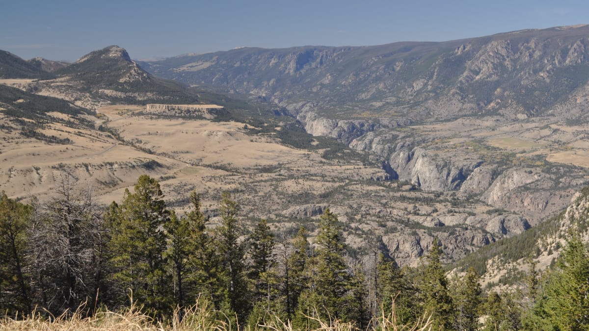
Chief Joseph Scenic Highway
Wyoming
Few roads in the American West feel as wild and as empty as the Chief Joseph Scenic Highway. This is Wyoming Highway 296, a lonely ribbon of pavement that leaves the high sagebrush country northwest of Cody, climbs in tight switchbacks to the top of Dead Indian Pass near eight thousand feet, then drops into the vast and quiet Sunlight Basin before running on to the foot of the Beartooth Highway. In roughly forty-six miles you cross a whole world of country, from open range to alpine pass to deep river canyon, and you may pass only a handful of other cars the entire way.
This route is a Wyoming State Scenic Byway, and it is named for a man and a people who traveled this hard country long before any road existed. In 1877 Chief Joseph led the Nez Perce through these very mountains, fleeing the pursuing US Army on a long and desperate flight toward Canada. The road carries their name in memory of that journey. Today it is one of Wyoming's most breathtaking and least crowded drives, a fitting approach to any stay in the Cody country or a grand back door into Yellowstone.
Learn about Chief Joseph Scenic Highway
The Road
Wyoming Highway 296 is a two-lane, fully paved state highway that runs about forty-six miles between its junction with Wyoming Highway 120 northwest of Cody and its western end at the Beartooth Highway, US Route 212. There are no stoplights, no towns, and almost no buildings along the way. It is a road built for the scenery and for reaching the remote Sunlight Basin, which for much of the year it serves as the only way in and out.
The centerpiece of the drive is Dead Indian Pass, which crests around eight thousand feet as the highway climbs over the Absaroka Range. The approach to the summit is a set of dramatic switchbacks that hairpin up the mountainside, and the overlook at the top is one of the great unmarked panoramas in the state. From there the land falls away toward the Sunlight Basin and the Clarks Fork of the Yellowstone River, an enormous sweep of mountain and valley that stops most travelers in their tracks.
Beyond the pass the highway winds down into the basin and along country cut by deep gorges. It crosses Sunlight Creek on a tall steel bridge, the highest bridge in all of Wyoming, spanning a narrow rock chasm far below. Farther on, the mouth of Clarks Fork Canyon opens up, a sheer-walled cleft where the river tumbles out of the mountains. The whole way the road feels remote and unhurried, a genuine escape into big, empty, beautiful country.
How to Get There
Most travelers reach the Chief Joseph Scenic Highway from Cody, Wyoming, the lively frontier town that serves as the eastern gateway to Yellowstone. From Cody, drive north on Wyoming Highway 120 for about seventeen miles to the well-marked junction where Wyoming Highway 296 branches off to the west. The scenic highway begins right there and climbs toward Dead Indian Pass, so the great views start not long after you leave the main road.
Coming from the west or from Montana, you can reach the highway's other end by way of the Beartooth Highway, US Route 212. The Beartooth climbs over its own high plateau from Red Lodge, Montana, and passes through the tiny towns of Cooke City and Silver Gate near Yellowstone's Northeast Entrance. Where US 212 meets Wyoming Highway 296, you can turn onto the Chief Joseph and follow it southeast over Dead Indian Pass toward Cody.
Because the two roads connect, many travelers drive the Chief Joseph Scenic Highway and the Beartooth Highway together as one grand loop, using Cody and Cooke City as the anchors at either end. It makes for one of the finest full-day mountain drives in the northern Rockies.
History
The road is named for Chief Joseph, the celebrated leader of the Nez Perce, and for the extraordinary journey his people made through this country in the summer of 1877. Refusing to be forced onto a reservation, several bands of Nez Perce set out on a fighting retreat that would cover well over a thousand miles as they tried to reach safety in Canada. Pursued by the US Army, they passed through what is now Yellowstone and threaded these rugged mountains, including the wild ground along the Clarks Fork, terrain so broken that the pursuing soldiers struggled to follow. It was a feat of endurance and navigation that is still studied and remembered today.
Dead Indian Pass, the high point of the modern drive, takes its somber name from events tied to that pursuit. By tradition, the name recalls a Nez Perce warrior who stayed behind near the top of the pass to watch for the advancing cavalry and was killed there. The name has stuck to the pass ever since, a reminder that the beautiful country the highway crosses was also the setting for a hard chapter of American history. The route is understood to roughly follow the path the Nez Perce took as they moved through these mountains.
For most of its history this was not a place you could drive at all. The idea of a road linking the Cody country with the Sunlight Basin and the Beartooth country took decades to become real. Construction stretched across many years and cost tens of millions of dollars, a difficult and expensive undertaking given the steep grades and remote terrain. The finished, fully paved highway was dedicated in 1995, and with that the Chief Joseph Scenic Highway finally opened as a continuous route and took its place among Wyoming's designated State Scenic Byways.
Today the highway is prized precisely because it stayed wild. It runs through country that is still largely undeveloped, with the Absaroka Range on one side and the Beartooth high country beyond, and it gives ordinary travelers a window onto landscapes that once could only be crossed on foot or horseback. In naming the road for Chief Joseph and the Nez Perce, the state tied a modern scenic drive to one of the most remembered journeys in the history of the West.
Little-Known Facts
- The Chief Joseph Scenic Highway is named for Chief Joseph and the Nez Perce, who passed through this rugged country in 1877 during their long fighting retreat of more than a thousand miles toward Canada.
- Dead Indian Pass, the highway's roughly eight-thousand-foot summit, is said to take its name from a Nez Perce warrior who stayed behind near the top to watch for pursuing cavalry and was killed there.
- The highway crosses Sunlight Creek on the highest bridge in the entire state of Wyoming, a tall steel span that leaps a narrow rock gorge far below.
- Sunlight Creek Bridge was built in the 1980s and stands hundreds of feet above the bottom of the gorge, making the crossing one of the most dramatic single moments on the drive.
- The paved highway took decades and tens of millions of dollars to build across such steep and remote terrain, and it was finally dedicated in 1995.
- For much of the year, Wyoming Highway 296 serves as the only road access into the remote Sunlight Basin, which sits tucked among the mountains along the route.
- The road roughly traces the path the Nez Perce took through the Clarks Fork country, terrain so broken that the pursuing US Army struggled to follow them.
- Because it connects directly to the Beartooth Highway, the Chief Joseph is often driven as half of a grand loop, pairing two of the northern Rockies' most spectacular mountain drives in a single day.
Along the Route
Dead Indian Pass Overlook
Dead Indian Pass is the high point and the signature stop of the whole drive, cresting around eight thousand feet after a series of dramatic switchbacks that climb the mountainside. The roadside overlook at the summit takes in one of the great unmarked panoramas in Wyoming, with the land falling away toward the Sunlight Basin and the distant Clarks Fork country. It is free, roadside, and usually uncrowded, so it is easy to pull over and simply take it in.
Sunlight Basin
West of the pass the highway drops into the vast, quiet Sunlight Basin, a broad sweep of mountain valley ringed by peaks and cut by creeks. It is one of the most remote basins in the region, and for much of the year the Chief Joseph Scenic Highway is the only paved way in or out. The openness and the silence here are the whole point, a genuine sense of big, empty country.
Sunlight Creek Bridge
The highway crosses Sunlight Creek on the highest bridge in all of Wyoming, a tall steel span that leaps a narrow rock gorge with the creek far below. There is a small pullout near the bridge where you can stop and peer down into the chasm, a dizzying and memorable moment. It is a striking piece of engineering in an otherwise wild and undeveloped stretch of road.
Clarks Fork Canyon
Clarks Fork Canyon is a sheer-walled gorge where the Clarks Fork of the Yellowstone River tumbles out of the mountains onto the open plains. The mouth of the canyon rises in dramatic cliffs, and this rugged country is part of the terrain the Nez Perce crossed in 1877. It is a wild and beautiful place, one of the natural gateways at the eastern edge of the drive.
Beartooth Highway Junction
The western end of the Chief Joseph Scenic Highway meets the Beartooth Highway, US Route 212, one of the great mountain drives on the continent. From this junction you can climb the Beartooth over its high alpine plateau toward Red Lodge, Montana, or continue on to the quiet Northeast Entrance of Yellowstone. Many travelers link the two roads into a single grand loop, making this junction the natural pivot point of the trip.
Details
Cody
Frequently asked questions
Is the Chief Joseph Scenic Highway a designated scenic byway, and when?
Yes. The Chief Joseph Scenic Highway, Wyoming Highway 296, is a Wyoming State Scenic Byway. The fully paved highway was dedicated in 1995 after decades of difficult construction, and it took its place among Wyoming's designated scenic byways as a continuous route linking the Cody country with the Beartooth Highway.
How long is the Chief Joseph Scenic Highway, and how long does it take to drive?
The highway runs about forty-six miles between its junction with Wyoming Highway 120 northwest of Cody and its western end at the Beartooth Highway, US Route 212. Driven straight through, it takes roughly an hour, but most travelers give it longer to stop at Dead Indian Pass and the other overlooks along the way.
What are the must-see stops along the Chief Joseph Scenic Highway?
The signature stop is the overlook at Dead Indian Pass, with its sweeping view over the Sunlight Basin and the Clarks Fork country. Other highlights include the tall Sunlight Creek Bridge, the highest in Wyoming, the broad and remote Sunlight Basin itself, and the dramatic mouth of Clarks Fork Canyon. The junction with the Beartooth Highway at the western end is a natural place to continue the adventure.
Is the Chief Joseph Scenic Highway free to drive?
Yes. The Chief Joseph Scenic Highway is a public state highway, so driving it and stopping at the roadside overlooks is free. There is no toll and no pass required for the road itself. If you continue on into Yellowstone National Park by way of the Beartooth Highway and the Northeast Entrance, a park pass is required to enter the park.
What is the best time of day or year to drive the Chief Joseph Scenic Highway?
Summer and early fall are the prime seasons, when the pass is clear and the high country is at its best. Morning and late-afternoon light are especially beautiful on the mountains and the basin. Because the road is high and exposed, the driving season is much shorter than on lower valley roads, so summer is the safest bet for a comfortable trip.
Is the Chief Joseph Scenic Highway open year-round?
The highway can be affected by winter weather, and snow at the higher elevations, especially around Dead Indian Pass, can bring hazardous conditions or temporary closures. The pass is much more exposed than the valley roads nearby. Always check current road and weather conditions with the Wyoming Department of Transportation before setting out in the colder months, and be aware that the connecting Beartooth Highway closes entirely for the winter.
Do you need four-wheel drive to drive the Chief Joseph Scenic Highway?
No. The Chief Joseph Scenic Highway is a fully paved, two-lane state highway, and any passenger car can handle it in good weather. Four-wheel drive is not required. In winter or during a storm, though, the high pass can be snowy or icy, so good tires and cautious driving matter far more than the type of vehicle.
What are the winter driving conditions on the Chief Joseph Scenic Highway?
Winter driving here can be demanding. The climb over Dead Indian Pass reaches around eight thousand feet and is exposed to wind and snow, so conditions at the top can be far worse than at the bottom. Storms can move in quickly. If you must drive in winter, check road and weather reports first, carry warm gear and supplies, and be prepared to turn back if the pass is closed or hazardous.
Are there gas stations or services along the Chief Joseph Scenic Highway?
No. This is a very remote highway with essentially no services, no fuel, and no towns along its length. Fill up and stock up before you go. Coming from the east, Cody is the place to get fuel, food, and supplies. Coming from the west, Cooke City near Yellowstone's Northeast Entrance is the nearest option. Start the drive with a full tank.
Should I expect to see wildlife, and how should I be prepared?
Yes. This is wild, undeveloped country, and you may see deer, elk, and other animals near the road, along with the occasional bear. It is bear country, so if you stop to hike or picnic, use standard bear-country caution, keep food secured, stay aware of your surroundings, and never approach wildlife. Watch for animals on the pavement, especially around dawn and dusk.
Nearby

Chief Joseph Scenic Highway
0.1 miles away
Chief Joseph Scenic Highway (WY-296) runs 47 miles from Cody to Cooke City, Montana through the Absaroka Range country that Nez Perce Chief Joseph led his people through in 1877 during the epic 1,170-...

Beartooth Highway
15 miles away
This is one of the great mountain drives on the continent. The Beartooth Highway leaves Red Lodge and climbs in tight switchbacks onto the Beartooth Plateau, cresting close to 11,000 feet at Beartooth...
Smith Mansion
20 miles away
Driving the North Fork Highway between Cody and Yellowstone, you round a bend and there it is: a lopsided five-story tower of logs stacked and jutting at impossible angles on a hillside.
Old Trail Town
21 miles away
On the western edge of Cody, this is a real frontier street assembled from actual buildings that were hauled in from across the region and reconstructed.

Buffalo Bill Center of the West
21 miles away
Five full museums under one roof in downtown Cody make this the deepest single collection of the American West anywhere: Plains Indian art, Western painting, the life of Buffalo Bill, Yellowstone-coun...