Toketee Falls
Idleyld Park, OR
Idleyld Park, OR
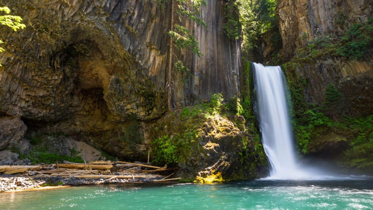
One of the most photographed waterfalls in Oregon, where the North Umpqua drops in two steps inside an amphitheater of hexagonal basalt columns.
Toketee Falls is one of the most recognizable waterfalls in Oregon, and much of that is thanks to the rock. The North Umpqua River spills over two drops here, a short upper step and a taller lower plunge, and both are set inside a curved wall of columnar basalt, tall stone pillars stacked like organ pipes around a deep green pool. The name comes from a Chinook Jargon word often translated as graceful, and it fits.
Getting to the view is part of the experience. A forest trail follows the river for a short distance, climbing and descending a staircase through Douglas fir and moss before it delivers you to a railed deck looking straight at the falls. It is a small, well-loved stop on the long North Umpqua corridor, the kind of place people pull off for and remember.
What Travelers Love
- The wall of stacked basalt columns that frames the falls like a natural cathedral
- A short forested trail along the river that ends at a railed viewing deck
- The deep blue-green plunge pool below the lower drop
- The quiet, old-forest feel of the whole North Umpqua corridor around it
Worth Knowing
- The viewpoint trail includes a long staircase, so the walk is more up-and-down than its short distance suggests
- The classic head-on view is from the deck; scrambling down to the pool is steep, unofficial, and can be dangerous
- A large wooden pipeline runs beside part of the trail, part of an old hydroelectric system, so the walk in is not fully wilderness
- Parking is limited and fills on warm summer weekends, so an early start helps
Learn about Toketee Falls
The story of Toketee and the North Umpqua
The North Umpqua country has been home to Native people for thousands of years. The wider Umpqua watershed lay within the homeland and seasonal range of the Umpqua peoples, whose descendants today are enrolled in the Cow Creek Band of Umpqua Tribe of Indians, a federally recognized tribe based in southwestern Oregon. Traditionally the Cow Creek people moved with the seasons, spending summers in the mountains and winters in the valleys, fishing salmon and lamprey and gathering game, roots, and berries across a territory that reached from the Coast Range east toward the Cascades and Crater Lake.
In 1853, in one of the earliest treaties signed in the region, the tribe ceded its homeland and was later removed. After long decades of effort, the Cow Creek Band regained federal recognition in 1982, and the tribe remains an active presence in the Umpqua country today. When you read the name Toketee, drawn from the trade language once spoken across the Pacific Northwest, you are hearing an echo of that long human history along the river.
The setting most visitors notice is shaped by more recent work too. A wooden stave pipeline runs alongside part of the trail, carrying water for a small hydroelectric project on the North Umpqua that dates to the mid-twentieth century. It is an unusual sight, a large old pipe threading through the forest, and a reminder that this corridor has long been valued for its water as well as its beauty.
How the basalt columns formed
The stacked pillars that frame Toketee are columnar basalt, and they formed the way such columns almost always do: from lava that cooled slowly and evenly. Geologists trace the rock here to volcanic flows off the Cascade Range, in the general vicinity of Mount Bailey, that spread across this ground long ago. As a thick sheet of lava cooled, it contracted and cracked into a honeycomb of vertical joints, splitting the rock into the many-sided columns you see towering over the pool.
The North Umpqua then went to work. Over a very long span of time the river cut down through those layers of hardened lava, carving the narrow slot and amphitheater that hold the falls. Where the water lands, swirling currents drive sand, gravel, and cobbles in circles against the bedrock, drilling out rounded potholes in the stone, a slow grinding that keeps reshaping the pool.
The result is a two-step falls: a shorter drop above and a taller sheer plunge below, together falling something over a hundred feet. Published heights vary a little depending on the source, so it is best to treat the numbers as close approximations rather than exact measurements, and simply enjoy the proportions, which are what make the scene so photographed.
Wildlife and the forest
The North Umpqua is famous among anglers as a wild summer steelhead river, and those sea-run fish are the ecological heart of the corridor, running up from the Pacific through this country on their way to spawn. The river also holds native trout, and the cold, clean water is the reason the whole valley feels so alive.
Along the trail, watch the creek and river edges for the American dipper, a small slate-gray songbird that walks and swims underwater to hunt insects, bobbing on the rocks between dives. Overhead the forest is home to woodpeckers, including the big, crow-sized pileated woodpecker whose drumming carries through the trees, and to owls that hunt the canyon after dark.
The forest itself is classic western Cascade woodland: Douglas fir and western hemlock rising over sword fern and deep moss, with bigleaf maple along the wetter ground. Black-tailed deer are common, and black bear and other larger animals range through the surrounding national forest, though they usually keep well out of sight.
Season by season
Spring brings the highest, loudest water, fed by rain and Cascade snowmelt, and the forest turns vivid green. Trails can be wet, and the North Umpqua Highway sits at enough elevation that early-season conditions can still be cold.
Summer is the most popular time, with warm, settled weather, long daylight, and easy access, though the small parking area fills quickly on weekends and an early arrival is wise.
Fall cools the air and thins the crowds, and the bigleaf maples add color along the river as the autumn rains begin to swell the flow again.
Winter is quiet and can be strikingly beautiful, but the corridor is high enough for snow and ice, and the trail staircase can be slick, so sure footing and current road and weather conditions matter before you go.
Closest Boutels
The closest Boutel™ stays, so you can turn this stop into an overnight. Each is a place we chose through independent editorial review, never a paid placement.
Details
Idleyld Park, OR
Frequently asked questions
What makes Toketee Falls special?
Toketee is one of the most beautiful and photographed waterfalls in Oregon, famous for the sheer columns of basalt that frame it like the pipes of a great organ. The North Umpqua River drops in two tiers, a short upper fall and a graceful eighty-five-foot plunge, into a deep blue-green pool. Thanks to steady upstream flows, it looks impressive in almost any season.
How hard is the hike to Toketee Falls?
The trail is short, under a mile round trip, but it is not a flat stroll: it winds along the gorge and includes a lot of stairs, so it is moderate rather than easy and is not wheelchair accessible. Most reasonably fit visitors manage it comfortably in well under an hour. Wear decent shoes, and bring water on a hot day, since the climb back up the steps can be work.
Can you go to the base of Toketee Falls?
The official trail ends at a railed overlook with a superb view, and going down to the base is strongly discouraged. Some people climb over the fence and scramble down the steep, unstable slope to the pool, but it is off-trail, genuinely dangerous, and has led to serious injuries. The safe and respectful choice is to enjoy the falls from the viewpoint and stay behind the railing, especially with children.
When is the best time to visit Toketee Falls?
The falls flow reliably year-round, so there is no bad season, but the trail is most pleasant from spring through fall when it is free of snow and ice. Summer is popular, so an early start means a quieter viewpoint and easier parking. Spring adds greenery and fuller side streams, and autumn brings color to the gorge.
What else is nearby to see with Toketee Falls?
It sits along the scenic North Umpqua corridor on the way toward Crater Lake, in an area rich with water features. The tall, misty Watson Falls is just up the road, and the rustic Umpqua Hot Springs, set on a bluff above the river, are close by as well. Together they make a rewarding day of waterfalls and soaking along one of Oregon's prettiest river routes.
Nearby

Umpqua Hot Springs
4.2 miles away
The springs sit about 20 feet above the North Umpqua on a rocky ledge. The water temperature in the hottest pools can be near 110 degrees, with cooler mixing pools below.
Diamond Lake
16 miles away
The lake sits in a broad, shallow crater at 5,183 feet, filled with snowmelt and surrounded by pumice flats and lodgepole pine.
Natural Bridge on Upper Rogue River
18 miles away
Natural lava tubes that capture a full river are rare. The tube here is large enough that the Rogue runs through it at full volume rather than seeping.

Crater Lake Rim Drive
25 miles away
The Cleetwood Cove Trail descends 1.1 miles to the lake and is the main place where you can touch the water. The trail is steep; plan 30 minutes down, 45 up.

Crater Lake National Park
30 miles away
The deepest lake in the United States, filling the caldera of a collapsed volcano with impossibly blue water.