
Thor's Well and the Devil's Churn
Cape Perpetua Scenic Area, US-101
Yachats, OR
The Oregon coast at its most theatrical: a hole that seems to drink the sea, and a chasm where the surf detonates against the rock.
The central Oregon coast has plenty of pretty overlooks, but Cape Perpetua has something rarer: coastline that puts on an actual performance. At the right tide, Thor's Well looks for all the world like a drain in the middle of the sea, the ocean rushing in, filling a dark bowl in the basalt, then falling away as if the Pacific were being emptied down a hole. A short walk north, the Devil's Churn does the same violence in a different key, funneling incoming waves up a long, narrow rock chasm until they slam into its tightening walls and blow skyward.
Neither is a trick or a built attraction. Both are natural sculptures carved by thousands of years of surf into the hard volcanic rock of the headland, and both belong to the public as part of the Cape Perpetua Scenic Area in the Siuslaw National Forest. Catch them near high tide, especially with a winter swell running, and you understand why photographers and storm-watchers make the pilgrimage to this one stretch of shore.
What Travelers Love
- Watching the tide pour into Thor's Well and appear to drain the whole ocean into the rock
- Standing above the Devil's Churn as a wave races the narrow chasm and explodes against its walls
- The easy Captain Cook Trail loop that strings the tide pools, Spouting Horn, and the Well together
- The whole moody Cape Perpetua scene: forest, headland, tide pools, and the big view from the overlook above
Worth Knowing
- The show depends entirely on the tide, so time your visit for about an hour before to an hour after high tide, and it is biggest with winter and storm swell
- The basalt is uneven, slick, and low to the surf, so keep well back, never turn your back on the ocean, and watch for sneaker waves
- It is a day-use area within the national forest, so a recreation pass or fee may apply, and the visitor center is a good first stop for tide times
- There are two parking pull-outs near Cook's Chasm south of the visitor center, and a short trail down to the rocky shelf for both features
Learn about Thor's Well and the Devil's Churn
How the rock made the show
Cape Perpetua is built of ancient basalt lava flows that poured to the sea and hardened, then met the relentless work of the Pacific. Along the intertidal shelf, the surf found seams and weaknesses in the rock and began to widen them, and over many thousands of years it carved the caves, fissures, and inlets that give the cape its drama. Thor's Well and the Devil's Churn are two of the most spectacular results.
Thor's Well, geologists now think, began life as a sea cave: waves hollowed out a chamber in the basalt until at last the roof gave way, leaving openings top and bottom. Now, when the tide fills the chamber from below, water surges up through the top and then drops back, so from the shelf it seems to pour into a bottomless hole. The Devil's Churn is a long, narrow inlet where deep fractures let the surf race far up a tightening channel, so an incoming wave detonates against the closing walls and throws spray high into the air.
A headland with 6,000 years of visitors
People have been coming to this coast for a very long time. Native peoples frequented Cape Perpetua for more than six thousand years, harvesting crabs, clams, mussels, and sea urchins from its rich intertidal rocks, and the shell middens they left are part of the story the scenic area tells. The cape kept its Indigenous life long before any European saw it from the water.
The name came later and from a distance. In March of 1778 Captain James Cook, sailing past but never landing, named the headland Cape Perpetua for Saint Perpetua, whose feast fell on that day. The English names attached to its features, Thor's Well, the Devil's Churn, Cook's Chasm, Spouting Horn, all came later still, the kind of vivid labels a wild, thundering coast tends to earn.
Seeing them safely, and what else is here
The features live and die by the tide. Come at low tide and Thor's Well is just a quiet hole and the Churn a calm slot; come about an hour before to an hour after high tide, ideally with a strong winter or storm swell, and both come violently alive. That same power is the danger: the basalt is uneven and slick, the surf comes in fast, and sneaker waves are a real and deadly hazard. Watch from a safe distance back, never turn your back on the ocean, and keep children and dogs close.
Both are reached from pull-outs near Cook's Chasm just south of the Cape Perpetua Visitor Center, with a short walk down to the rocky shelf, and the easy one-mile Captain Cook Trail loop links the tide pools, Spouting Horn, and Thor's Well in one go. Make the visitor center your first stop for the day's tide times, then, if you have the time, drive the winding road up to the Cape Perpetua Overlook, the highest viewpoint on the Oregon coast reachable by car, for the big picture of the whole thundering headland.
Closest Boutels
The closest Boutel™ stays, so you can turn this stop into an overnight. Each is a place we chose through independent editorial review, never a paid placement.
Details
Yachats, OR
Frequently asked questions
When is the best time to see Thor's Well?
Thor's Well is most dramatic around high tide or an incoming tide, when the surging ocean fills the bowl and appears to drain the sea into the hole, and it is wildest of all when a storm is pushing big swells ashore. Aim for the hour or two around high tide and check a tide table before you go. At low tide the well is far less active, though the tide pools nearby are easier to explore then.
Is Thor's Well dangerous?
It can be, and it deserves real respect. The rocks around Thor's Well and the Devil's Churn are pounded by powerful surf, and this coast is known for sneaker waves, sudden surges that rush much farther up the rocks than the waves before them and have swept people off the shoreline. The safest approach is to keep well back, never turn your back on the ocean, keep children close, and stay off the low rocks entirely when the surf is big or a storm is running.
What is the Devil's Churn?
The Devil's Churn is a narrow, deep chasm in the basalt just up the coast from Thor's Well, where the ocean funnels into a tight inlet and explodes upward in bursts of spray, sometimes shooting far into the air. Like Thor's Well, it is most powerful on an incoming or high tide, and it is best admired from the viewpoints and upper trail rather than the slick rocks at the water's edge.
How do I photograph Thor's Well safely?
Photographers love the spot, but the dramatic shots draw people dangerously close to the surf, which is how accidents happen. Scout your position at low tide when it is calmer, set up well back from the well itself, keep constant watch on the sets of incoming waves, and never turn your back on the water for a shot. A telephoto lens lets you capture the drama from a safe distance, and no photo is worth being caught by a wave.
Where exactly are Thor's Well and the Devil's Churn?
They lie along the rocky shore at Cape Perpetua on the central Oregon coast, just south of Yachats. Thor's Well and the nearby Spouting Horn are at Cook's Chasm, and the Devil's Churn is a short way up the highway, all within the Cape Perpetua area, which also has forest trails and one of the highest coastal viewpoints in Oregon. It is easy to see all of them in one visit if you time the tide well.
Nearby
Cape Perpetua Tidepools
0.6 miles away
Cape Perpetua tidepools are among the best kid-friendly tide pool spots on the coast: giant green anemones, purple sea urchins, hermit crabs, and sea stars in pools that are waist-deep for an adult an...
Smelt Sands State Recreation Site
3.0 miles away
A small rocky-shore state site at the north edge of Yachats where surf pounds volcanic basalt, and the trailhead of the historic, largely accessible 804 Trail. Turn west off US-101 near milepost 163.
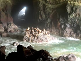
Sea Lion Caves
11 miles away
Sea Lion Caves delivers on its promise: an elevator drops you into a cathedral-sized sea cave packed with Steller sea lions hauled out on the rocks.