
Cape Perpetua
Yachats
Cape Perpetua is the highest viewpoint you can drive to on the Oregon Coast, a forested basalt headland that rises some 800 feet straight out of the surf near Yachats. From the little stone shelter at the top, built by hand during the Depression, the view can run more than 30 miles up and down the coast on a clear day and far out over the Pacific, where gray whales pass offshore.
Down at the water it gets loud. The same volcanic rock that forms the cape has been carved by the sea into a set of natural theatrics: Thor’s Well, a gaping hole that seems to drain the ocean; Devils Churn, a narrow chasm where waves explode; and the Spouting Horn, which fires seawater into the air at high tide. Between them lie some of the richest tidepools on the coast.
Learn about Cape Perpetua
The story of Cape Perpetua
The cape got its name from a passing ship. On March 7, 1778, Captain James Cook sighted this stretch of coast from the sea, too rough and stormy to land, and named the headland for Saint Perpetua, whose feast day it was. Cook never set foot ashore. The name stuck anyway.
Long before that, this was the southern country of the Alsea people, who camped by the creek mouth below the cape. They left behind great shell middens, mounds of clam and mussel shells built up over centuries of gathering, that you can still walk past along the trails today.
The cape holds a harder history as well. Amanda’s Trail, which climbs the headland, is named for Amanda De-Cuys, a blind Coos woman who in 1864 was force-marched some eighty miles up the coast to the reservation at Yachats. A soldier who was there, Corporal Royal Bensell, wrote in his diary that on the last day her bare feet dragged over the sharp volcanic rock of Cape Perpetua, leaving “blood sufficient to track her by.” The trail was built in the 1990s to remember her and the many Native people displaced in those years.
In 1933 a Civilian Conservation Corps camp opened at Cape Creek, and the crews built much of what visitors use today: the picnic areas, the first trails, and the sturdy stone West Shelter at the summit, perched about 800 feet above the sea. They also helped push the Roosevelt Highway, now Highway 101, along this wild edge of coast.
Thor’s Well, and how the cape was made
The whole headland began as fire. More than 30 million years ago an undersea volcano laid down thick beds of basalt here, and slow uplift and endless waves have been shaping them ever since into the cape and its rocky shelf. The sea does the fine carving.
Thor’s Well began as a sea cave whose roof collapsed, leaving a hole perhaps twenty feet deep that fills and drains with every surge, so that at the right stage of the tide it looks for all the world like a drain emptying the Pacific. Nearby, Devils Churn is a long, narrow slot where incoming waves compress and burst upward, and the Spouting Horn shoots spray through a hole in the rock like a geyser.
All three are at their most dramatic on an incoming tide with a good swell, and all three demand respect. Sneaker waves here have swept people off the rocks, so it is a place to watch from a safe distance, not to climb down to.
Whales, tidepools, and a 500-year-old tree
The rocky benches below the cape hold some of the best tidepools on the coast, protected within a marine reserve. At low tide they brim with life: orange and purple ochre sea stars, fat green anemones, clusters of purple urchins, mussels, and hermit crabs. Along the shore, watch for black oystercatchers working the rocks and murres on the offshore stacks.
From the headland this is a prime whale-watching perch. Gray whales pass offshore on their long migration in winter and spring, and a group of them lingers to feed off this coast through the summer, often close enough to spot their spouts from the overlook.
Inland, a short walk up Cape Creek leads to the Giant Spruce, a Sitka spruce roughly 500 years old, more than 185 feet tall and some 40 feet around. It stood taller still until the Columbus Day Storm of 1962 tore the top thirty-odd feet off in winds above 160 miles an hour. It grew from a fallen nurse log, so its base now arches on root legs over the gap where the old log rotted away.
Season by season
Winter is storm-watching season, when big swells turn Thor’s Well and Devils Churn into thundering spectacles and gray whales begin moving south past the cape. Dress for wind and rain, and keep well back from the water.
Spring brings the northbound whale migration and the first calm, clear days, with wildflowers out on the headland.
Summer is best for the tidepools and the trails, with the calmest seas and a resident group of gray whales feeding just offshore. Time a tidepool visit to a low tide.
Fall quiets the crowds and brings the storms back, a fine season to have the overlooks nearly to yourself.
Closest Boutels
The closest Boutel™ stays, so you can turn this stop into an overnight. Each is a place we chose through independent editorial review, never a paid placement.
Frequently asked questions
What is the best time to see Thor's Well and the Spouting Horn?
These are tide-driven features, so timing matters. Thor's Well and the Spouting Horn put on their most dramatic show around high tide or an incoming tide, when the surging water fills and drains the well and shoots up through the horn, and they are wilder still when a storm is rolling in. Check a tide table before you go and plan your visit around it.
When can I explore the tide pools at Cape Perpetua?
The tide pools are best at low tide, the opposite of when Thor's Well is most active, so if tidepooling is your goal, aim for a low tide. The rocky marine garden here shelters sea stars, anemones, mussels, barnacles, and purple urchins. Step carefully on the wet rocks, look but leave the creatures where they are, and watch your footing.
How do I stay safe on the rocks at Cape Perpetua?
The ocean here deserves real respect. This stretch of coast is known for sneaker waves, sudden surges that rush far higher up the rocks than the waves before them and have swept people off the shoreline. The safest approach is to keep well back from the water's edge, never turn your back on the ocean, keep children close, and stay off the low rocks entirely when the surf is big or a storm is running. The views are just as good from a safe distance.
What is there to do at Cape Perpetua besides Thor's Well?
Quite a lot. Cape Perpetua rises to one of the highest viewpoints on the Oregon coast, reached by road or trail to a stone overlook shelter with a huge ocean panorama. Behind the headland, forest trails wind through old-growth Sitka spruce, including a path to a giant centuries-old tree, and Devil's Churn, a narrow chasm where the surf crashes and churns, lies just up the road.
When is the best time of year to visit Cape Perpetua?
It is rewarding year-round, but each season offers something different. Summer brings the calmest, clearest weather for tidepooling and hiking, while late fall and winter storms make Thor's Well, the Spouting Horn, and Devil's Churn far more powerful and dramatic, though the coast is also at its most dangerous then. Whenever you come, dress in warm, waterproof layers, as the headland is often windy and wet.
Nearby
Thor's Well and the Devil's Churn
0.1 miles away
Two of the Oregon coast's most theatrical natural features, carved by the surf into the basalt of Cape Perpetua.
Smelt Sands State Recreation Site
2.9 miles away
A small rocky-shore state site at the north edge of Yachats where surf pounds volcanic basalt, and the trailhead of the historic, largely accessible 804 Trail. Turn west off US-101 near milepost 163.
Sea Lion Caves
11 miles away
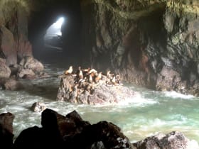
Sea Lion Caves delivers on its promise: an elevator drops you into a cathedral-sized sea cave packed with Steller sea lions hauled out on the rocks.