

Steens Mountain
Steens Mountain Backcountry Byway
Frenchglen, OR
A whole mountain tilted skyward, its west side climbing gently to a mile-high rim that drops a sheer mile to the desert floor, cut by glacier gorges and roamed by wild Spanish mustangs.
Steens Mountain is not a peak so much as a tilted world. Ages of basalt lava piled up here thousands of feet thick, and then the earth's faulting hinged the whole slab upward on its western edge and dropped it away on the east, so the mountain climbs gently for miles from the sagebrush flats to a rim nearly 9,700 feet high, then falls off in a single sheer wall almost a mile straight down to the Alvord Desert. It is one of the largest fault-block mountains in North America, and the road that climbs it is the highest in Oregon.
Along the way the mountain shows what the Ice Age did to it. Glaciers gouged four immense U-shaped gorges into the basalt, and from the overlooks you gaze down into their green, half-mile-deep bowls. Wild mustangs graze the high country, bighorn sheep pick along the escarpments, and from the East Rim the desert floor spreads out so far below and so far into the distance that on a clear day you can see into Nevada, Idaho, and California from a single spot.
What Travelers Love
- Standing on Oregon's highest road and looking a mile straight down to the Alvord Desert
- The vast U-shaped glacier gorges, especially the sweeping bowl of Kiger Gorge
- Spotting the wild Kiger mustangs, descendants of Spanish horses, in the high country
- Total dark skies and total silence, with no cell service and hardly another car
Worth Knowing
- The Steens Mountain Loop is the highest road in Oregon and only opens roughly July through mid-October; snow closes it the rest of the year
- The road is gravel, rough in spots, and remote, so a high-clearance vehicle, a full tank, water, and a spare are wise, and there is no cell service
- Weather at the rim near 9,700 feet turns fast and cold even in summer, so carry layers whatever the forecast in the valley
- This is public BLM land with no services on the mountain; fuel and supplies come from Burns or the little store at Frenchglen
Learn about Steens Mountain
A mountain tilted like a trap door
Between roughly fifteen and eight million years ago, floods of basalt lava built this ground up in layer after layer, thousands of feet thick. Then movement along a fault on the eastern side lifted and tilted the entire block, hinged along its western edge like a trap door swung open to the sky. That is why Steens has such a strange, lopsided shape: from the west you barely notice you are on a mountain as the road rises gradually across sage and aspen, and only at the very top does the ground vanish beneath you in a cliff that plunges nearly a mile to the desert.
During the Ice Age, glaciers settled into the high folds of the mountain and slowly carved it, grinding out four enormous U-shaped gorges, Kiger, Little Blitzen, Big Indian, and Wildhorse. Kiger Gorge is the showpiece, a clean, sweeping glacial valley about half a mile deep, its walls so smoothly scooped that it looks almost sculpted. Short walks and overlooks along the loop let you stand at the lip of these canyons and read the whole story of ice on rock.
Wild horses and high-desert life
In 1977 the Bureau of Land Management found a herd of wild horses on and around Steens whose bloodline, later confirmed by DNA testing, traces largely back to the Spanish horses brought to North America in the 1600s. These are the Kiger mustangs, prized for their dun coats, dark dorsal stripes, and tough, compact build, and they became so admired that the breed is now bred and sought after far beyond Oregon. The Kiger Mustang Viewing Area east of Frenchglen is the classic place to try to spot a band of them running free.
The mustangs are only part of the wildlife. Bighorn sheep negotiate the rocky rim, and pronghorn, mule deer, and elk range the slopes below. At the mountain's foot lie the wetlands of the Malheur National Wildlife Refuge, one of the great bird stopovers of the West, so a trip to Steens easily pairs a day of high-country overlooks with a morning of marsh birding down on the flats.
Oregon's highest road and the view off the edge
The Steens Mountain Loop, a backcountry byway of roughly fifty-nine miles beginning near Frenchglen, is the highest road in the state, topping out close to 9,700 feet. It is gravel and it is remote, and it only opens for a short summer window, usually early July into mid-October, before snow shuts it down again. Driving it slowly, stopping at the overlooks, is the heart of a Steens visit.
The moment everyone remembers comes at the East Rim Viewpoint. You walk to the edge and the world simply drops away, nearly a mile down to the flat white bed of the Alvord Desert, with basin and range marching off to the horizon. On a clear day the view runs past Oregon's borders into three other states. It is the kind of overlook that makes people go quiet, a reminder of just how big and empty this corner of the country still is.
Because it is so high and so far from anywhere, Steens is also one of the darkest places in Oregon. When night comes the Milky Way pours across the sky from rim to rim, and with no towns and no cell service for many miles, the silence is as complete as the dark.
Visiting Steens Mountain
Steens rises south of Burns, and the loop road runs up from Frenchglen, a tiny historic outpost with a store and a handful of rooms at the mountain's base. Because the byway only opens in summer and is gravel and rough in places, come prepared: a full tank, water and food, a spare tire, and a vehicle that can handle backcountry road. There is no cell service on the mountain and no fuel or supplies, so stock up in Burns or Frenchglen first.
Give the loop most of a day so you can linger at Kiger Gorge, the East Rim, and the wildflower meadows, and start early to beat afternoon weather, which can turn cold and stormy at the rim even in July. Watch for the mustangs, walk out to at least one canyon overlook, and if you can, stay for the stars. Steens rewards patience: it is not a quick photo stop but a whole day of driving into one of the wildest, highest, and loneliest landscapes Oregon has.
Closest Boutels
The closest Boutel™ stays, so you can turn this stop into an overnight. Each is a place we chose through independent editorial review, never a paid placement.
Details
Frenchglen, OR
Frequently asked questions
When is the Steens Mountain Loop Road open?
Only in the warm months. The roughly sixty-mile gravel loop, the highest road in Oregon, typically opens in early July once the high passes clear of snow and closes again by mid-October when winter returns. So plan a summer or early-fall visit, and always check current road status before setting out, since conditions and opening dates shift from year to year with the snow.
What should I know before driving the Steens loop?
It is a rough, remote backcountry drive, not a casual scenic road. Expect miles of rocky, dusty gravel that demand a high-clearance vehicle and a good spare tire, since flats are common, and plan on a slow pace, at least half a day to do it justice. There is no cell service, so bring paper maps, plenty of water, food, and fuel, and pack warm layers even in July, as weather at nine thousand feet changes fast.
What are the must-see stops on Steens Mountain?
The great glacier-carved gorges are the highlights, above all Kiger Gorge, where a short walk from the road reveals an immense U-shaped valley curving away below, one of the most jaw-dropping views in Oregon. Big Indian and Little Blitzen gorges and the summit overlook, high above the Alvord Desert far to the east, are also stunning. Give yourself time to stop often along the loop.
Can you see wild horses at Steens Mountain?
Yes, this is the home of the famous Kiger mustangs, a wild herd found to descend largely from Spanish horses brought to the Americas centuries ago, recognizable by their dun color and dark dorsal stripe. There is a designated viewing area east of Frenchglen where you have the best chance of spotting them, though as with all wildlife, sightings are never guaranteed. Keep a respectful distance if you find them.
When is the best time to visit Steens Mountain?
Mid to late summer offers the fullest access with the whole loop open, alpine wildflowers blooming in the high country, and the warmest, driest weather. Early fall adds golden aspen color in the gorges before the road closes. Even at the height of summer, the summit is cold and windy, so bring layers, start early to allow a full unhurried day, and come completely self-sufficient for this remote corner of Oregon.
Nearby
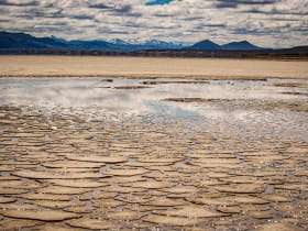
Alvord Desert
5.9 miles away
The Alvord playa is one of the flattest surfaces in Oregon and one of the more surreal. Looking east from the playa, the land runs flat toward Idaho with no interruption.
Peter French Round Barn
23 miles away
Peter French was shot and killed on New Year's Day 1897 by a homesteader disputing his land claims, one of the more dramatic endings to the cattle wars era in Oregon.

Malheur National Wildlife Refuge
46 miles away
The refuge sits in a closed basin with no drainage to the ocean, a remnant of a much larger prehistoric lake that covered much of the Harney Basin during the last ice age.