

Salt Creek Falls
Willamette Pass
Salt Creek Falls is one of the tallest waterfalls in Oregon, a plunge of roughly 286 feet off a basalt cliff that is commonly ranked second in the state after Multnomah Falls. (That long-standing figure comes from the Forest Service signs at the site; modern laser surveys suggest the true drop may be a little less.) What makes it remarkable is how easy it is to reach: most travelers crossing Willamette Pass on Highway 58 never realize a waterfall this size is a two-minute walk from the parking lot.
Pull in, follow the paved path to the overlook, and the ground simply falls away into a mossy basalt canyon with the creek thundering down the far wall. In hard winters the spray freezes the rim into ice. And behind the falling water, a rare bird nests here that is found nowhere else in the state.
Learn about Salt Creek Falls
The story of Salt Creek Falls
The falls take their name from Salt Creek, which was itself named for a set of salty mineral springs downstream that draw deer and elk as natural salt licks. The name comes from the water, not the waterfall.
The first recorded visit dates to March 1887, when a Lane County settler named Frank Warner reached the falls with his guide, Charlie Tufti, a man of Molala ancestry who homesteaded near Oakridge and was known to early settlers as a guide and mediator. Tufti Mountain is named for him.
The Cascade crest here lies within the homelands of the Molala, who lived across these western Cascades near the range of the Klamath to the south. The two peoples traded, intermarried, and hunted together, part of a web of trans-Cascade routes linking the Klamath, the Kalapuya of the Willamette Valley, and peoples east of the mountains. Descendants of the Molala are enrolled today with the Confederated Tribes of Grand Ronde, the Confederated Tribes of Siletz Indians, and the Klamath Tribes.
The push to cross these mountains began in 1864, when the Oregon pioneer Byron Pengra organized a company to build a military wagon road from Eugene over the Cascades. His survey party, moving under a cavalry escort, mapped the route up the valley and over the crest in 1865. One of his surveyors, William Odell, gave his name to the deep lake just east over the pass.
What truly opened the country was the railroad. The Southern Pacific spent two decades building its Cascade line over the pass, reaching Oakridge by 1912 and completing the summit crossing in 1926. Oakridge grew into a rail and timber town, home to big sawmills, until the timber economy collapsed in the early 1980s. It has since reinvented itself as one of the great mountain-biking destinations in the Northwest.
How the falls and canyon formed
Salt Creek Falls sits in the High Cascades, and its canyon is a collaboration between ice and fire. More than a million years ago a glacier carved a broad valley here. Later, lava flows, cited as issuing from Fuji Mountain and Mount Yoran, poured through and filled part of it with roughly 300 feet of basalt. The creek now drops over the lip of that ledge, its narrow canyon walls formed of the tall, columnar basalt the region is known for.
The last ice age left its signature everywhere you look. The main glacier deepened the Salt Creek valley far below its side streams, leaving smaller valleys ‘hanging’ high on the canyon walls, and glacial meltwater and the creek itself finished carving the gorge. Because the falls are fed by snowmelt, they run hardest in late spring and early summer.
The rare swifts behind the water
Salt Creek Falls holds a distinction found nowhere else in Oregon: it is the only known nesting site in the state for the black swift, a scarce, scythe-winged bird that builds its nest on the wet ledges directly behind the curtain of falling water. The swifts arrive in late spring, raise a single chick through the summer, and are gone by fall, wintering as far away as the Amazon basin of Brazil. Watch for them wheeling over the canyon at dusk, and keep your distance during nesting season.
Down at creek level, look for the American dipper working the whitewater just above the falls, and Vaux’s swifts overhead. The surrounding old-growth forest is home to Townsend’s and hermit warblers, and a pair of northern waterthrush sometimes nests in the marshy ground just upstream. Deer and elk visit the salt-lick springs that gave the creek its name.
The forest is old-growth Douglas fir, western hemlock, and mountain hemlock, and in June wild rhododendrons bloom pink along the trails.
Season by season
In winter the Salt Creek Sno-Park makes this a base for cross-country skiing, with a network of Nordic trails and warming shelters, and in hard cold snaps the falls themselves freeze into a partial wall of ice.
Spring brings peak flow, the falls at their most thunderous with Cascade snowmelt, and the first rhododendron blooms toward June.
Summer is the season for the Diamond Creek Falls Loop, a few miles of old-growth shade, wildflowers, and a second, fan-shaped waterfall, and it is when the black swifts are nesting behind the main falls.
Fall quiets the trails and turns the forest to color before winter closes the high country back down.
Closest Boutels
The closest Boutel™ stays, so you can turn this stop into an overnight. Each is a place we chose through independent editorial review, never a paid placement.
Frequently asked questions
How hard is it to see Salt Creek Falls?
Very easy. Salt Creek Falls is Oregon's second-tallest waterfall, a single plunge of nearly three hundred feet, and the main observation platform sits just a short, flat walk from the parking area, railed and accessible. For a fuller view of the whole drop, a path of about a third of a mile leads down to a lower platform. Longer loop trails along the canyon rim reward those who want more.
Can you hike to other waterfalls from Salt Creek Falls?
Yes. A loop of a few miles links Salt Creek Falls with the lovely Diamond Creek Falls along the canyon rim, and you can extend it to take in Fall Creek Falls as well for a longer day. The trails pass viewpoints, forest, and, in early summer, blooming rhododendrons. Wear sturdy shoes and carry water, and take care near the unrailed canyon edges.
Can you visit Salt Creek Falls in winter?
You can, though it takes a little effort. The main observation site is closed to cars in winter, so visitors park at the nearby Salt Creek Sno-Park and walk a short distance along the road to the falls, often on snow, which makes it a popular snowshoe or cross-country ski outing. A Sno-Park permit is required in the winter months, and the snowy falls are a beautiful reward.
When is the best time to visit Salt Creek Falls?
The falls roar most impressively in late spring and early summer with the snowmelt, and early to mid-June is a favorite for the blooming rhododendrons alongside the trails. Summer and fall offer easy access and pleasant hiking, while January and February draw snowshoers and skiers to the frozen scene. There is really no bad time, only different experiences.
Do I need a pass to visit Salt Creek Falls?
Usually yes. In the warmer months the trailhead requires a Northwest Forest Pass or a day-use pass, and in winter a Sno-Park permit is needed to park at the Sno-Park nearby. It is worth having the right pass before you arrive so you are set either way. There are restrooms at the observation site during the open season.
Nearby

Waldo Lake Wilderness
8.1 miles away
One of the clearest lakes on earth, with visibility past 100 feet because no rivers run in. Gas motors are banned, so it belongs to kayaks, canoes, and sailboats.
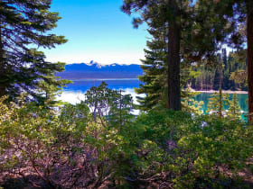
Crescent Lake, Deschutes National Forest
10 miles away
The color is the reason to come: deep blue-green and improbably transparent, clarity that comes from volcanic snowmelt and great elevation.
Oakridge Trail System
21 miles away
The old logging trails above Oakridge reborn as one of the country's great mountain-bike networks, more than 300 miles of Cascade singletrack.

Crater Lake Rim Drive
43 miles away
The Cleetwood Cove Trail descends 1.1 miles to the lake and is the main place where you can touch the water. The trail is steep; plan 30 minutes down, 45 up.

Crater Lake National Park
49 miles away
The deepest lake in the United States, filling the caldera of a collapsed volcano with impossibly blue water.