
Rio Grande Gorge Bridge
US-64, El Prado, NM
Taos, NM
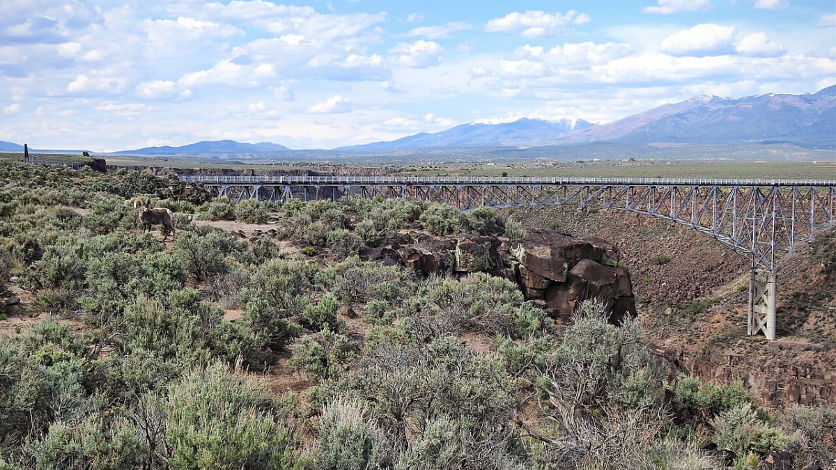
A slender steel arch carrying the highway across a chasm nearly 600 feet deep, with a sidewalk that lets you walk right out over the void.
From the road there is nothing to warn you. The Taos Plateau runs flat and brown to the horizon in every direction, and then the ground simply falls away and the Rio Grande Gorge Bridge carries the highway out over a chasm that drops close to six hundred feet to the river below. It is one of the highest bridges in the United States, and few places let you feel the scale of the American West so suddenly and so completely.
The gorge itself is the heart of the Rio Grande del Norte National Monument, where the river has cut straight down through layers of old volcanic rock to leave a slot canyon hundreds of feet deep across an otherwise empty tableland. A sidewalk runs along each side of the bridge, so you can park at the free rest area, walk out to a viewing cutout at the middle of the span, and stand there with the wind pushing at you and the river a silver thread far, far down.
What Travelers Love
- Walking the sidewalk out to the middle of the bridge and looking straight down to the tiny river far below
- The sheer, dramatic drop into the gorge and the wide plateau views on every side
- Watching for bighorn sheep on the rock walls and hawks riding the wind over the canyon
- A free rest area with parking, restrooms, and local artisans selling jewelry and art
Worth Knowing
- It is very exposed and often windy up on the plateau, so hold onto hats and keep a close eye on children near the edge
- The sidewalks are narrow and cars pass close by, so stay behind the railings and mind traffic
- There are no services out here beyond the rest area, so bring water and fuel up in Taos first
- Pedestrian access to the walkway can change for safety work, so it is worth checking before a long detour
Learn about Rio Grande Gorge Bridge
A bridge built to leap a canyon
When engineers set out to carry U.S. 64 west from Taos in the early 1960s, the Rio Grande Gorge stood in the way, too deep and too steep to fill or to detour around easily. Their answer was a steel deck arch bridge, its roadway riding on top of a great curved arch of steel that springs from one rim of the canyon to the other. Construction began in 1963, and the bridge was dedicated in September 1965.
The whole structure runs about 1,280 feet long, with a 600-foot main span in the center flanked by two 300-foot approaches. Sources have long argued over exactly how high it stands above the water, with figures from about 565 to 650 feet, but any way you measure it the drop is enormous. In 1966 the American Institute of Steel Construction named it the most beautiful long-span steel bridge built that year, and it earned a place on the National Register of Historic Places in 1997.
Standing over the void
The experience is simple and unforgettable: you leave your car, walk out along the sidewalk, and step into one of the viewing cutouts that bump out from the middle of the span. From there you can look straight down the sheer rock walls to the Rio Grande winding along the canyon floor. People with a fear of heights often get no farther than a peek, and the plateau wind that comes across the open ground only adds to the drama.
Look outward and the gorge runs off to the north and south in a jagged line across the plain, with the Sangre de Cristo Mountains standing blue on the eastern horizon. Scan the canyon walls and you may spot bighorn sheep picking their way along ledges, or hawks and ravens riding the updrafts. Sunrise and sunset set the rock glowing and are the favorite times for photographers, though the middle of a clear day shows the depth of the gorge at its starkest.
The gorge and the monument around it
The bridge is only the most famous viewpoint of a much larger wild landscape. In 2013 the surrounding country was set aside as the Rio Grande del Norte National Monument, hundreds of thousands of acres of high sage plain, extinct volcanoes, and the deep gorges of the Rio Grande and the Red River. It is managed by the Bureau of Land Management and laced with trails for those who want more than the view from the bridge.
Right at the west end of the bridge, a free rest area gives you parking, restrooms, and picnic tables, and Native American artisans often set up nearby to sell jewelry and other work. From the same spot the West Rim Trail runs for miles south along the very lip of the canyon, an easy, level path with the gorge always at your side, so a quick photo stop can just as easily turn into a long walk on the rim.
Visiting the Rio Grande Gorge Bridge
The bridge sits about ten miles west of Taos on U.S. 64, an easy and well-signed drive from town, and there is no fee to visit or to park at the rest area. Give yourself time for the walk out to the middle and back, and dress for wind and open sun, since there is almost no shade on the plateau. Watch children closely near the railings and stay on the sidewalks away from passing traffic.
It pairs naturally with the other great sights around Taos, from the ancient adobe of Taos Pueblo to the off-grid Earthship homes just up the road, so it fits neatly into a day of exploring. Come for ten minutes and you will still remember the moment the ground dropped out from under the highway; come at the right light, with time to walk the rim, and it becomes one of the finest stops in northern New Mexico.
Closest Boutels
The closest Boutel™ stays, so you can turn this stop into an overnight. Each is a place we chose through independent editorial review, never a paid placement.
Pinon Court by La Fonda
Honorable Mention201 Montezuma Avenue, Santa Fe, NM
56 miles away|Learn More ›
Details
Taos, NM
Frequently asked questions
What is the Rio Grande Gorge Bridge?
The Rio Grande Gorge Bridge, near Taos in northern New Mexico, is a spectacular steel arch bridge soaring some six hundred feet above the Rio Grande as it flows through a deep, dramatic gorge. One of the highest bridges in the country, it offers breathtaking, vertigo-inducing views down into the rugged canyon and out across the high-desert landscape and mountains. A pedestrian walkway lets visitors walk out onto the bridge to take in the stunning scenery. An engineering landmark and a favorite scenic stop near Taos, the Rio Grande Gorge Bridge provides an awe-inspiring perspective on the powerful river and the beautiful, wild country of northern New Mexico.
Can you walk on the Rio Grande Gorge Bridge?
Yes, the bridge has pedestrian walkways along both sides, separated from the vehicle traffic, that allow visitors to walk out over the gorge and peer down at the Rio Grande far below and take in the sweeping views. There are viewing platforms along the bridge. Walking out offers a thrilling and dramatic experience, though those uneasy with heights should know the drop is dizzying. A rest area with parking and, often, vendors sits at the west end. Walking the bridge for the stunning views is a highlight of a visit, so take your time and enjoy the scenery.
What safety tips apply at the Rio Grande Gorge Bridge?
When walking the bridge, stay on the pedestrian walkway, hold onto hats, phones, and belongings, as it can be very windy, keep children close, and be mindful of the traffic on the bridge. The great height and open views are dramatic, so those uncomfortable with heights should take care. Watch your footing at the viewing areas and stay behind railings. In the high-desert setting, bring sun protection and water. Being mindful of the wind, height, and traffic, and keeping a firm hold on children and belongings, ensures a safe visit to this spectacular bridge.
When is the best time to visit the Rio Grande Gorge Bridge?
The bridge and its views can be enjoyed year-round, with clear days offering the best visibility into the gorge and across the landscape, and the light especially beautiful in the morning and evening for photography. Spring through fall brings the most pleasant weather, while winter can be cold and windy at this high elevation. The bridge is often windy, so bring layers. Sunrise and sunset offer gorgeous light on the gorge and mountains. For the best combination of comfortable weather and beautiful views, aim for a clear day in the milder months, ideally in the golden hours.
What is near the Rio Grande Gorge Bridge?
The Rio Grande Gorge Bridge is near Taos in northern New Mexico, close to the historic Taos Pueblo, the town of Taos with its plaza and art galleries, the Taos Ski Valley, and within reach of the Rio Grande del Norte National Monument and the surrounding high-desert and mountain scenery. That makes the Rio Grande Gorge Bridge a spectacular scenic stop to combine with Taos Pueblo, the town of Taos, and the many attractions of northern New Mexico on a visit to the state.
Nearby
Taos Pueblo
11 miles away
Taos Pueblo is a living Native American community a few miles north of Taos where people have made their home in multistory adobe houses for roughly a thousand years, a UNESCO World Heritage Site and...

El Santuario de Chimayo
35 miles away
Chimayo is genuinely unlike any church experience you can have in the United States.
Plaza Blanca
36 miles away
Plaza Blanca is the quieter, stranger cousin of the famous red cliffs at Ghost Ranch nearby.