
Quabbin Reservoir
Scherer Rd, Belchertown, MA
Belchertown, MA
One of the largest man-made public water supplies in the country, a wilderness of islands and eagles built by drowning four whole towns beneath its water.
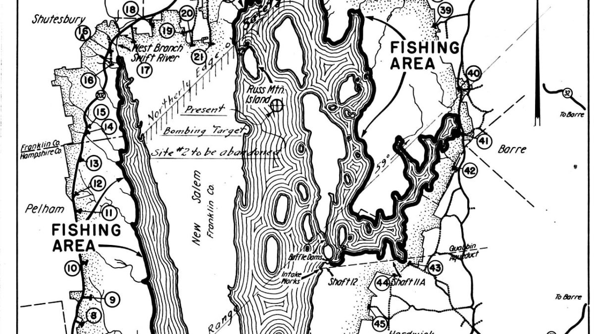
Quabbin Reservoir is one of the largest man-made public water supplies in the United States, a body of water so big it can hold well over four hundred billion gallons and supplies drinking water to Boston and much of eastern Massachusetts, more than forty miles away. Ringed by tens of thousands of acres of protected forest, it looks and feels like true wilderness, its long fingers of water studded with wooded islands that were hilltops before the valley was flooded.
The reservoir's beauty carries a heavy story. To build it in the 1930s, the state deliberately erased four entire towns, Dana, Enfield, Greenwich, and Prescott, moving thousands of residents, unearthing their cemeteries, and letting the water rise over their homes, roads, and town commons. What is now a haven for bald eagles and loons was once a settled valley of farms and villages, and the memory of those drowned towns gives Quabbin an atmosphere unlike anywhere else in New England.
What Travelers Love
- The great view from Enfield Lookout, taking in miles of water, wooded islands, and often bald eagles
- Walking or biking the Winsor Dam and the quiet, gated woods roads around the shore
- The eerie, moving history of four towns that lie beneath the surface
- The wild feel of a place kept undeveloped to protect the water, alive with deer, loons, and eagles
Worth Knowing
- This is Boston's drinking water, so swimming and wading are not allowed and much of the shore is kept protected
- Fishing and boating are permitted only in season and under strict rules to keep the water clean
- Gates open and close seasonally and by area, so check which roads and trails are accessible before you go
- Cell service is thin and the reservation is large, so bring water and let someone know your plans
Learn about Quabbin Reservoir
The four towns beneath the water
By the early twentieth century, a booming and thirsty Boston needed far more water than its own region could provide, and engineers fixed on the broad, sparsely settled Swift River valley as the ideal place to make a reservoir. Doing so meant destroying the communities that lived there. In 1938 the four towns of the valley, Dana, Enfield, Greenwich, and Prescott, were officially disincorporated, wiped from the map by act of the legislature.
The human toll was wrenching. Residents were forced to sell and leave homes and farms their families had held for generations, buildings were torn down or burned, forests were cleared, and even the dead were moved, with thousands of graves dug up and reburied in a new cemetery. On a spring night in 1938 the towns held a final farewell ball in Enfield; when the band stopped near midnight, the valley's old life effectively ended. Over the next several years the rising water covered the cellar holes, roads, and commons, and the four towns passed beneath the surface.
Building the reservoir
The reservoir was formed by damming the Swift River with two great earthen structures, Winsor Dam and Goodnough Dike, and then diverting additional water into the basin through a long tunnel bored beneath the hills. The valley filled slowly over about seven years, from the late 1930s into the mid-1940s, until the water reached the level it holds today.
From the reservoir, the water travels entirely by gravity through a system of deep aqueducts and tunnels the long distance to metropolitan Boston, needing no pumping, a feat of engineering that still serves millions of people. To keep that water clean, the state has left the whole watershed largely undeveloped and forested ever since, which is exactly why Quabbin became, almost by accident, one of the wildest large landscapes in southern New England.
An accidental wilderness
Because the land around Quabbin has been protected and closed to development for the better part of a century, it has grown into a genuine refuge for wildlife. The reservoir is famous as a place to see bald eagles, which were reintroduced here in the 1980s in a landmark restoration effort and now nest around its shores. Loons call across the water, ospreys fish it, and the surrounding woods hold deer, moose, black bear, bobcat, and beaver.
For visitors, the reward is quiet. The Enfield Lookout offers a sweeping view over the water and islands and is one of the best eagle-watching spots in the state. Miles of gated woods roads make fine walking and biking, winding through forest and past old stone walls and cellar holes that hint at the vanished farms. It is a landscape to move through slowly and listen to.
Rules, respect, and the seasons
Everything at Quabbin is shaped by its first purpose: protecting drinking water. Swimming and wading are prohibited, and boating and fishing are allowed only in season and under strict rules meant to keep contaminants out. Large stretches of shoreline are closed entirely. Visitors who understand and respect those limits find the payoff is a rare kind of undisturbed nature so close to a major city.
The reservation shifts with the year. Spring brings returning eagles and loons and rushing streams. Summer is green and full, the best stretch for permitted fishing and boating. Autumn sets the surrounding hills ablaze and reflects them in the still water, the most beautiful season to walk the shore roads. Winter is stark and quiet, with some areas gated shut, so it is wise to check what is open before setting out.
Closest Boutels
The closest Boutel™ stays, so you can turn this stop into an overnight. Each is a place we chose through independent editorial review, never a paid placement.
Details
Belchertown, MA
Frequently asked questions
What is Quabbin Reservoir?
Quabbin Reservoir is the largest body of water in Massachusetts, a vast and scenic reservoir created in the 1930s by damming the Swift River, which flooded four small towns to supply drinking water to the Boston area. Ringed by protected forest and dotted with islands that were once hilltops, it is a place of striking beauty and poignant history, and a haven for hiking, wildlife watching, and sweeping views over the water.
What can you do at Quabbin Reservoir?
Popular activities include hiking to the Quabbin Observation Tower and the Enfield Lookout, where interpretive signs tell the story of the lost towns beneath the water and offer beautiful views, along with walking or biking designated routes and fishing in permitted areas. It is also outstanding for wildlife, especially bald eagles, which nest and soar over the reservoir, plus deer, moose, and black bears in the surrounding woods.
Can you swim at Quabbin Reservoir?
No. Because Quabbin is an unfiltered public drinking-water supply, swimming and wading are strictly prohibited, and recreation is limited to hiking, fishing, and biking on designated routes to protect the water. Dogs are also not allowed anywhere in the park or reservation. So plan to enjoy the reservoir by viewing it from the trails and lookouts rather than entering the water, and respect the posted rules that keep the supply clean.
What should I know before visiting Quabbin Reservoir?
There is no fee to visit and parking is available at the main areas. The biggest practical caution is ticks, which are common in the woods and grass, so wear long pants and repellent and check yourself afterward. Stay on the designated trails and gates, bring water, and remember dogs are not permitted. Following the rules and preparing for ticks makes for a safe, rewarding visit to this beautiful protected landscape.
When is the best time to visit Quabbin Reservoir?
Spring through fall is ideal for hiking and wildlife watching, and mid-to-late October is spectacular, when the forested hills around the reservoir blaze with autumn color. Winter can be excellent for spotting bald eagles over the open water. Early mornings are quietest and best for wildlife. Whatever the season, a clear day rewards you with the finest views from the tower and Enfield Lookout.
Nearby
Emily Dickinson Museum
9.2 miles away
One of the great American poets lived almost her entire life inside this one house, and you can stand in the room where she wrote.
Yiddish Book Center
9.5 miles away
Few people expect a world center of Jewish culture tucked into a college campus in the Pioneer Valley.

Historic Deerfield
20 miles away
It looks like a film set, but every house is real and original.