
Clingmans Dome (Kuwohi)
Kuwohi, North Carolina
Cherokee, NC
The highest peak in the Smokies, sacred to the Cherokee as Kuwohi, crowned by a spiral ramp that lifts you above a dark forest of spruce and fir.
At more than 6,600 feet, this is the highest peak in the Great Smoky Mountains and the highest point in Tennessee, standing on the state line at the very crest of the range. For generations it was mapped as Clingmans Dome, but in 2024 it was officially restored to its Cherokee name, Kuwohi, meaning roughly mulberry place, honoring the mountain's deep importance to the Eastern Band of Cherokee Indians.
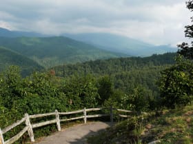
The summit is famous for the spiral concrete ramp that lifts visitors above the treetops to a round observation platform, offering a sweeping view across the endless blue ridges of the Smokies. The forest here is unlike anything in the lowlands, a cool, dark stand of red spruce and Fraser fir that feels more like Canada than the American South.
What Travelers Love
- The spiral observation ramp lifting you above the treetops
- A dark, fragrant forest of spruce and fir found nowhere else in the South
- Long-range views across ridge after ridge of the Smokies
- The restored Cherokee name Kuwohi and its deep cultural meaning
Worth Knowing
- The paved path to the tower is short but steep, so take your time at high elevation
- The access road is closed in winter, when snow and ice are common up top
- Bring a jacket; the summit is much cooler and windier than the valleys
- Sunrise and clear mornings offer the best chance at long views before haze builds
Learn about Clingmans Dome (Kuwohi)
Kuwohi and the Cherokee
The mountain has always held meaning for the Cherokee people, who know it as Kuwohi and regard it as a sacred place tied to their oldest stories and their history in these mountains. It was to these highlands that some Cherokee fled to escape forced removal on the Trail of Tears in the 1830s, and their descendants form the Eastern Band of Cherokee Indians who live on the nearby Qualla Boundary today.
In 2024, at the request of the Eastern Band, the peak's official name was changed back to Kuwohi, one of a growing number of places restoring Indigenous names. The Eastern Band remains a living community centered in Cherokee, with its own government, language revitalization efforts, and cultural institutions, and the restored name honors that continuing presence.
The observation tower and the view
From the parking area, a short but steep paved path climbs to the summit, where a distinctive spiral ramp rises to a circular observation platform above the trees. The design lifts visitors over the surrounding spruce and fir so the view opens in every direction across the mountains.
On a clear day the panorama stretches for a great distance across the layered ridges of the Smokies and beyond, though the same haze that gives the mountains their smoky name and blue color often softens the far horizons. Sunrise and clear, dry mornings offer the sharpest and most memorable views.
A forest out of place
The summit is cloaked in a spruce-fir forest, a cool, moist woodland of red spruce and Fraser fir that survives here as a relic of the last Ice Age. When the glaciers retreated and the climate warmed, these northern forests held on only at the highest, coolest elevations of the southern Appalachians, marooned like islands in the sky.
In recent decades many of the Fraser firs have died back, killed by an introduced insect called the balsam woolly adelgid, leaving stands of pale standing trunks among the survivors. The forest is slowly regenerating, and it remains a rare and fragile ecosystem found in only a handful of places in the South.
Seasons on the summit
Summer brings cool, comfortable days at the top while the valleys swelter, and it is the busiest season, so early mornings are best for both parking and views. Wildflowers bloom late here, and mist and passing clouds often drift right through the summit forest.
Fall is spectacular, with color climbing the mountain over many weeks. Winter closes the access road, and the summit is left to snow, rime ice, and hardy hikers who reach it on foot or by trail, a quiet and demanding season on the roof of the Smokies.
Closest Boutels
The closest Boutel™ stays, so you can turn this stop into an overnight. Each is a place we chose through independent editorial review, never a paid placement.
Riverhouse at the Park
Honorable Mention205 Ski Mountain Rd, Gatlinburg, TN
10 miles away|Learn More ›
Details
Cherokee, NC
Frequently asked questions
What is Kuwohi, formerly Clingmans Dome?
Kuwohi, long known as Clingmans Dome, is the highest peak in Great Smoky Mountains National Park and one of the highest in the eastern United States, straddling the North Carolina and Tennessee border. In 2024 the mountain's ancestral Cherokee name, Kuwohi, meaning mulberry place, was officially restored, honoring its deep significance to the Cherokee people, for whom it is a sacred place. At the summit, a distinctive observation tower reached by a steep paved path offers breathtaking, sweeping panoramic views across the Smokies, often above the clouds. With its sacred heritage and spectacular summit views, Kuwohi offers a spectacular destination in North Carolina.
Why was Clingmans Dome renamed Kuwohi?
The mountain was renamed Kuwohi in 2024 to restore its ancestral Cherokee name, meaning mulberry place, honoring the peak's deep and sacred significance to the Cherokee people, who have long revered it as an important place. The change, championed by the Eastern Band of Cherokee Indians, replaced a name given in the nineteenth century for a historical figure, returning the mountain to the name the Cherokee have always known. It reflects respect for Cherokee heritage and the land's original stewards. Understanding this restored name deepens the meaning of a visit to Kuwohi in North Carolina.
What can you do at Kuwohi?
You can walk the steep paved path from the parking area to the summit observation tower, taking in breathtaking panoramic views across the Great Smoky Mountains, often reaching above the clouds, learn about the mountain's Cherokee heritage and its sacred significance, and experience the high-elevation spruce-fir forest. The summit tower, the sweeping views, and the mountain's cultural and natural significance are the highlights, offering a memorable experience atop the Smokies. Approaching this sacred place with respect is encouraged. With its summit tower and views, Kuwohi offers a rewarding experience in North Carolina.
What should I know before visiting Kuwohi?
The paved path to the summit tower is short but quite steep, so taking your time and wearing sturdy shoes help, and the high summit is dramatically cooler, windier, and often cloudier or foggier than the lowlands, so bringing warm layers even in summer is essential, and views can be obscured on cloudy days. The access road is seasonal and closed in winter, so checking current road status before you go is wise. Approaching this sacred Cherokee place respectfully is appreciated. Coming prepared for the elevation ensures a rewarding visit to Kuwohi in North Carolina.
What is near Kuwohi?
Kuwohi, formerly Clingmans Dome, is in Great Smoky Mountains National Park on the North Carolina and Tennessee border, within reach of Cherokee with the Museum of the Cherokee People, the Great Smoky Mountains Railroad in Bryson City, Cataloochee Valley, Soco Falls, and the Blue Ridge Parkway. That makes Kuwohi a spectacular stop to combine with Great Smoky Mountains National Park, Cherokee, and the other attractions of western North Carolina on a visit to the state.
Nearby

Newfound Gap Overlook
5.3 miles away
The drive up from Gatlinburg over Newfound Gap is worth it for the view alone.
Salt and Pepper Shaker Museum
10 miles away
It sounds like a joke until you walk in, and then it just keeps going.
Cades Cove
18 miles away
Cades Cove is a broad valley of open meadow ringed by high forested ridges, a rare piece of level ground in the Smokies and the best place in the park to see wildlife.
Cataloochee Valley
24 miles away
A remote, quiet valley in Great Smoky Mountains National Park where wild elk graze the open fields at dawn and dusk and a whole 1800s Appalachian farm community stands preserved, with churches, a scho...