Newfound Gap Overlook
4591 Newfound Gap Rd, Gatlinburg, TN
Gatlinburg, TN
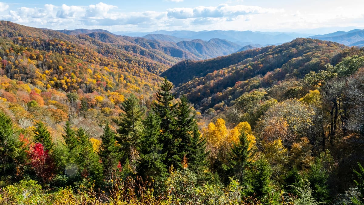
The highest point any road crosses in the Great Smoky Mountains, a mile-high pass on the state line where the ridges roll out in blue waves to the horizon.
Newfound Gap is the lowest drivable pass over the crest of the Great Smoky Mountains, and at the same time the highest point that any road reaches within the national park, a mile above sea level on the very line between Tennessee and North Carolina. From the overlook, the Smokies unfold in wave after wave of blue-green ridges, hazed with the moisture that gives the mountains their name.
The gap is more than a scenic pull-off. It is where the Appalachian Trail crosses the road on its long journey along the spine of the mountains, and it is where the Great Smoky Mountains National Park was formally dedicated, with a president in attendance. Standing here, at the meeting point of two states and two watersheds, is one of the defining experiences of a visit to the Smokies.
What Travelers Love
- Sweeping views over ridge after blue ridge from a mile above sea level
- Standing with one foot in Tennessee and one in North Carolina on the state line
- The Rockefeller Memorial where the national park was formally dedicated
- Cooler mountain air and a completely different forest from the valleys below
Worth Knowing
- At this elevation the weather is cooler and can change fast, so bring a layer even in summer
- The road can close in winter for snow and ice, so check park conditions before driving up
- Fog often rolls over the gap, so views come and go; give it time or return another hour
- The Appalachian Trail crosses right here, so expect to share the pass with long-distance hikers
Learn about Newfound Gap Overlook
The Cherokee homeland
These mountains are the ancestral homeland of the Cherokee people, who lived, hunted, and traveled through the Smokies for countless generations and knew every gap and ridge of them. The high country was crossed by long-used trails, and the mountains held a central place in Cherokee life and story.
In the 1830s most Cherokee were forced from these lands and driven west to Oklahoma on the Trail of Tears, a brutal removal that cost thousands of lives. Some managed to remain in the mountains, however, and their descendants form the Eastern Band of Cherokee Indians, whose town of Cherokee lies just down the North Carolina side of the gap. The pass looks out over land that has been Cherokee country far longer than it has borne any modern name.
The pass and its name
For a long time the main route over these mountains crossed at a different, higher gap. In the 1850s a surveyor identified this lower crossing as an easier way over the crest, and because it displaced the old route it came to be called the Newfound Gap. The name has stuck ever since, marking the discovery of a better path across a formidable barrier.
The pass sits at roughly a mile in elevation, low enough to carry a road yet high enough to be a true mountain crossing. The drive up to it climbs through changing bands of forest, and at the top the road straddles the boundary between Tennessee and North Carolina, letting visitors stand in two states at once on the highest paved point in the park.
Where the park was dedicated
Newfound Gap holds a special place in the story of the national park. At the overlook stands the Rockefeller Memorial, a stone platform built to honor a large gift from the Rockefeller family that helped make the park possible. In 1940 President Franklin D. Roosevelt stood on this spot to formally dedicate the Great Smoky Mountains National Park.
Because the memorial straddles the state line, Roosevelt spoke with the platform in both Tennessee and North Carolina, a fitting gesture for a park shared by the two states. The site remains a place to reflect on how the Smokies, once heavily logged and in danger of being lost, were pieced together from thousands of parcels through public effort and private generosity to become a protected national treasure.
The high forest, the trail, and the seasons
At this elevation the forest changes dramatically from the coves far below. Spruce and fir, trees more typical of far northern woods, cloak the highest ridges, and the cool, damp air supports mosses, ferns, and wildflowers suited to the mountaintops. The Appalachian Trail crosses the road here, and from the gap it climbs toward the highest peaks of the range, drawing day hikers and long-distance walkers alike.
The seasons transform the gap. Spring and summer bring wildflowers and cool relief from the valley heat, though fog is common and can swallow the views. Fall is spectacular, when the hardwoods below blaze with color and the crowds come for the show. Winter turns the pass cold and snowy, and the road can close entirely, so a clear winter day at the gap, with rime ice on the firs, is a rare and beautiful reward.
Closest Boutels
The closest Boutel™ stays, so you can turn this stop into an overnight. Each is a place we chose through independent editorial review, never a paid placement.
Details
Gatlinburg, TN
Frequently asked questions
What is the Newfound Gap overlook?
The Newfound Gap overlook, high in Great Smoky Mountains National Park on the Tennessee-North Carolina border, is a spectacular mountain pass and viewpoint at the highest point crossed by the road through the park, offering breathtaking panoramas of the Smokies. At the gap, where the main road crosses the crest of the mountains between Tennessee and North Carolina, sweeping views stretch across ridge after ridge of the misty blue mountains, and the Appalachian Trail crosses here. A historic spot where the park was dedicated, it is a beloved and easily reached highlight of the Smokies. A stunning and accessible mountain overlook, it delights visitors. With its panoramas, Newfound Gap offers a spectacular destination in Tennessee.
What can you do at the Newfound Gap overlook?
You can take in sweeping panoramic views across the misty ridges of the Great Smoky Mountains, stand at the Tennessee-North Carolina state line, access the Appalachian Trail that crosses here, see the historic spot where the park was dedicated, and photograph the beautiful mountain scenery. The spectacular views, the state-line crossing, the Appalachian Trail access, and the historic significance are the draws, making it a memorable and accessible highlight. The layered blue ridges are the highlight. With its views, Newfound Gap offers a rewarding experience in Tennessee.
What should I know before visiting the Newfound Gap overlook?
Newfound Gap is high in the mountains, where the weather is cooler and can change quickly, with fog, wind, rain, or snow possible even when it is mild below, so bringing layers and checking conditions are wise, and the road can close in winter weather. The mountain road is winding, so driving carefully matters. This is bear country, so being bear-aware is important. Dressing for mountain weather and checking road conditions ensure a rewarding visit to the Newfound Gap overlook in Tennessee.
When is the best time to visit the Newfound Gap overlook?
The mild months of spring through fall are the most pleasant for the overlook, with clear days offering the best views, spring and summer green, and fall spectacular for foliage across the mountains, while winter can bring snow and road closures at the high elevation. Because mountain weather and road conditions vary, checking current conditions before you go is wise. For the best views and pleasant weather, aim for spring through fall, with fall a foliage highlight, at the Newfound Gap overlook in Tennessee.
What is near the Newfound Gap overlook?
The Newfound Gap overlook is high in Great Smoky Mountains National Park on the Tennessee-North Carolina border, within reach of Cades Cove, the park's other areas, the gateway towns of Gatlinburg and Pigeon Forge with Dollywood, and North Carolina across the crest. That makes the Newfound Gap overlook a spectacular stop to combine with Cades Cove and the other attractions of the Great Smoky Mountains on a visit to Tennessee.
Nearby

Clingmans Dome
5.3 miles away
At 6,643 feet Clingmans Dome is the roof of the Smokies and the third highest summit in the eastern United States, and the spiral observation ramp at the top can open a view of a hundred miles across...
Salt and Pepper Shaker Museum
9.2 miles away
It sounds like a joke until you walk in, and then it just keeps going.
Cataloochee Valley
19 miles away
A remote, quiet valley in Great Smoky Mountains National Park where wild elk graze the open fields at dawn and dusk and a whole 1800s Appalachian farm community stands preserved, with churches, a scho...
Cades Cove
22 miles away
Cades Cove is a broad valley of open meadow ringed by high forested ridges, a rare piece of level ground in the Smokies and the best place in the park to see wildlife.