
Buckskin Gulch
Buckskin Gulch, Utah
Kanab, UT
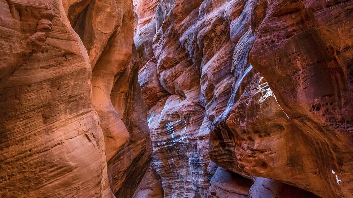
One of the longest and deepest slot canyons on earth, a twisting sandstone corridor so narrow and tall that daylight barely reaches its floor.
Buckskin Gulch is a legend among slot canyons, often called one of the longest and deepest slots on the planet. For mile after mile it winds through solid sandstone as a corridor sometimes only a few feet wide but many stories deep, so narrow and high that the sky becomes a thin ribbon overhead and the sun reaches the floor only briefly, if at all.
Set in the remote Paria Canyon-Vermilion Cliffs Wilderness on the Utah and Arizona line, the gulch is a bucket-list adventure for canyon hikers, prized for its sculpted walls, glowing reflected light, and profound solitude. It is also a serious and potentially dangerous place, subject to flash floods, requiring a permit, and demanding real preparation, which is exactly why reaching its depths feels like such an achievement.
What Travelers Love
- Walking for miles through a corridor of sculpted sandstone only a few feet wide
- The play of reflected light glowing on the towering, swirling canyon walls
- The deep quiet and solitude of one of the most remote slot canyons anywhere
- The sense of adventure in a truly wild and demanding desert landscape
Worth Knowing
- Flash floods are deadly here, so never enter with rain in the forecast anywhere upstream, and check conditions
- A permit is required to hike or backpack the gulch, so arrange one before you go
- This is remote wilderness with no water, services, or reliable cell signal, so come fully prepared and self-reliant
- Expect deep mud, cold pools, and possible obstacles, so it is a serious outing, not a casual stroll
Learn about Buckskin Gulch
How the slot was carved
Buckskin Gulch is cut into Navajo sandstone, the same pale, cross-bedded rock that forms the great cliffs and domes across this region, laid down as an immense field of ancient desert dunes and later hardened into stone. Flash floods have spent countless years scouring downward through this rock, deepening the channel faster than it could widen and leaving a slot far taller than it is wide.
Those same floods sculpted the walls into the swirling, fluted shapes that make the gulch so beautiful, and they continue the work today. Reflected light bouncing between the close walls glows orange and gold along the sandstone, and logs and debris jammed high overhead, called flood wrack, are a sobering record of how deep the water has run through this narrow corridor.
The flash-flood danger
The overwhelming hazard in Buckskin Gulch is flash flooding, and it must be taken with complete seriousness. Because the slot is so narrow and deep, there is often no way to climb out and no high ground to reach, so a wall of water from a storm, even one falling many miles away over the upstream watershed, can turn the canyon lethal in minutes.
For that reason hikers watch the weather obsessively, avoid the gulch entirely when rain is possible anywhere upstream, and never enter with storms in the forecast. The safest windows tend to be settled stretches of weather outside the summer monsoon, but conditions can change, so checking the latest forecast and any agency warnings is not optional. When in doubt, the rule is simple: stay out.
Permits and preparation
Buckskin Gulch lies within a managed wilderness, and a permit is required whether you hike it as a long day or backpack it, part of a system that protects both the fragile canyon and the people in it. Arranging a permit in advance is a necessary first step, and it is worth studying the current requirements and route conditions before committing.
Beyond the permit, this is remote, unforgiving country. There is no water to rely on, no services, and no dependable cell coverage, and the gulch itself can hold deep mud, cold wading pools, and occasional rockfall or obstacles that must be worked around. Hikers come with plenty of water, sturdy footwear they do not mind soaking, a way to navigate, and a plan shared with someone at home. It rewards preparation and punishes carelessness.
The wild land around it
The gulch is part of a vast and ancient landscape. This corner of the Colorado Plateau holds the traces of the Ancestral Puebloan peoples, and rock art and old inscriptions can be found in the wider Paria country, part of the deep human history of a region still meaningful to the tribes of the Southwest. The land beyond the slot rises into the banded cliffs of the Vermilion Cliffs, home to reintroduced California condors soaring on the thermals.
Life in the gulch itself is spare but present, with lizards and birds along the rim, and the surprising green of hanging gardens and seeps where water lingers. Beyond the narrows, the wilderness opens into the Paria River canyon and the famous, permit-limited sandstone waves of the surrounding country, some of the most sought-after and carefully protected scenery in the West.
Closest Boutels
The closest Boutel™ stays, so you can turn this stop into an overnight. Each is a place we chose through independent editorial review, never a paid placement.
Details
Kanab, UT
Frequently asked questions
What is Buckskin Gulch?
Buckskin Gulch is one of the longest and deepest continuous slot canyons in the world, winding roughly sixteen miles through towering, sculpted sandstone walls in southern Utah near the Arizona border. In its narrowest stretches the walls close in so tightly you can touch both sides at once, soaring hundreds of feet overhead while only a sliver of sky shows above. It is a legendary, awe-inspiring destination for slot-canyon lovers, offering an unforgettable journey through a dark, sinuous corridor of stone.
How dangerous are flash floods in Buckskin Gulch?
Extremely, and this is the single most important thing to understand. As a long, narrow slot with a huge upstream catchment, Buckskin Gulch is deadly during floods, and there are very few escape points once you are deep inside. A storm dozens of miles away, even the day before, can send floodwaters through the narrows hours later. Never enter when rain is falling or forecast anywhere in the region, check the weather carefully for the days around your hike, and turn back if conditions change.
Do you need a permit for Buckskin Gulch?
Yes. Day hiking requires an inexpensive permit, and overnight backpacking requires a separate permit with a limited number issued per day, which can sell out months in advance. Permits are available through the Bureau of Land Management, obtainable in advance at the Kanab office or online, so plan ahead, especially for an overnight trip. Securing your permit early and confirming current requirements before you go are essential parts of planning this hike.
How hard is hiking Buckskin Gulch?
The full canyon is a serious, long, non-technical but strenuous trek along a sandy, sometimes muddy floor, often done as a multi-day backpacking trip, and it can involve wading through pools and scrambling over debris. However, many day hikers simply enter from the popular Wire Pass trailhead and go a mile or two into the narrows before turning around, which offers a spectacular taste of the slot without the full commitment. Choose the option that matches your experience and preparation.
When is the best time to hike Buckskin Gulch?
Late spring, around April and May, and fall, September and October, are best, with mild temperatures, usually manageable water levels, and lower flash-flood risk. The July and August monsoon season is especially dangerous due to sudden, powerful storms and should generally be avoided. Whenever you go, come prepared for a remote desert canyon with plenty of water, sun protection, and sturdy footwear, and always prioritize the flash-flood forecast above all else.
Nearby
The Wave
5.2 miles away
The Wave is a striated sandstone formation on the Arizona-Utah border with curved, wave-like layers of red, orange, and white rock.
US-89A: Marble Canyon to Fredonia
18 miles away
US-89A between the Navajo Bridge and Fredonia passes below the Vermilion Cliffs, where the California condor reintroduction releases happen.

Vermilion Cliffs National Monument
19 miles away
Vermilion Cliffs is a remote 280,000-acre monument with some of the most dramatic geology in the Southwest.

UT-12 Scenic Byway
34 miles away
Utah Highway 12 runs 124 miles from US-89 near Panguitch to Torrey near Capitol Reef, crossing five distinct geological formations and three national park corridors.

Bryce Canyon National Park
40 miles away
The largest concentration of hoodoos on Earth, a natural amphitheater of orange and pink stone spires.

Zion National Park
55 miles away
Towering sandstone cliffs and the Virgin River carving the Narrows, one of the great slot-canyon hikes.