
Vermilion Cliffs National Monument
Marble Canyon, AZ
Marble Canyon, AZ
A wilderness of towering red cliffs and swirling sandstone in one of the emptiest corners of Arizona, home to soaring condors and the most sought-after slickrock in the West.
Vermilion Cliffs National Monument protects a vast and lonely stretch of red-rock country on the Arizona Strip, the remote wedge of the state north of the Colorado River. Its namesake feature is the great escarpment of the Vermilion Cliffs, a wall of red, orange, and buff sandstone that rises thousands of feet and runs for many miles, blazing with color in the low light of morning and evening. Established as a monument in 2000, it safeguards nearly three hundred thousand acres of cliffs, canyons, and slickrock.
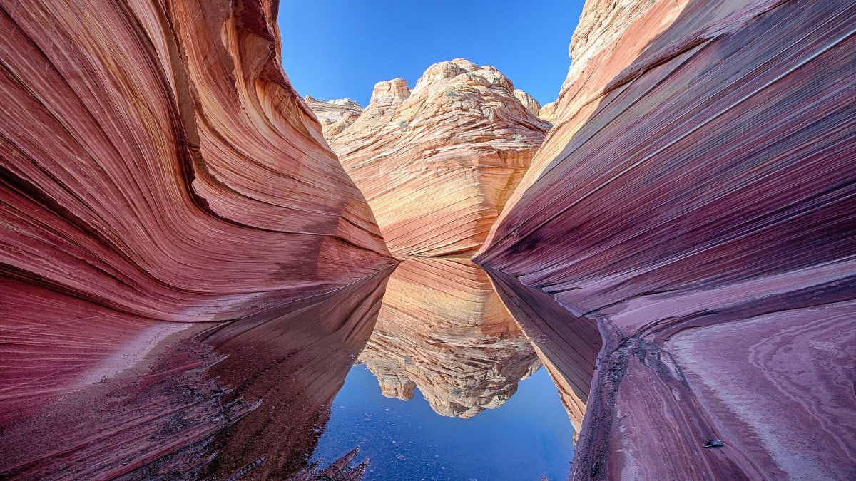
This is one of the wildest and least-traveled landscapes in the Southwest, a place of enormous silence and enormous beauty. It is best known for two things: the California condor, the giant vulture brought back from the edge of extinction and released here, and The Wave, a formation of swirled, banded sandstone so photogenic and so fragile that access is limited to a tiny number of permits each day. Beyond those famous features lie deep slot canyons, hidden arches, and miles of country almost no one ever sees.
What Travelers Love
- The immense red-and-gold wall of the cliffs glowing in low morning and evening light
- Watching California condors, saved from extinction, soar along the cliffs
- The otherworldly swirled sandstone of The Wave and the Coyote Buttes
- The deep, quiet solitude of one of the least-visited landscapes in the Southwest
Worth Knowing
- This is remote, rugged country with few services, so carry plenty of water, fuel, and supplies
- Access to the famous formation The Wave requires a hard-to-obtain permit through a lottery; do not attempt it without one
- Backcountry roads can require high clearance or four-wheel drive and become impassable when wet
- Summer heat is extreme and there is little shade, so the cooler months and early hours are safest for hiking
Learn about Vermilion Cliffs National Monument
The land and its first people
The country of the Vermilion Cliffs has been home to native peoples for thousands of years, from the ancestral Puebloan cultures whose granaries and rock art dot the canyons to the Southern Paiute, who knew the springs and hunting grounds of this arid land. The nearby Kaibab Band of Paiute Indians has a reservation to the west, and the vast Navajo Nation lies across the Colorado to the east and south. The land holds their history in its rock art, its ruins, and its place names.
For later travelers this was formidable country. The Colorado River blocked passage for hundreds of miles, until the ferry at nearby Lees Ferry, established in the 1870s, opened a crossing that Mormon settlers and others used to move between Utah and Arizona. The cliffs marked the edge of the habitable world for these travelers, a barrier and a landmark both. Today the monument preserves not only the geology but this deep human layering, from ancient dwellings to pioneer ruins.
How the cliffs and slickrock formed
The Vermilion Cliffs are one step of the Grand Staircase, an immense series of cliffs and terraces that climbs northward from the Grand Canyon into Utah, each step exposing older or younger rock. The cliffs themselves are cut into sandstones laid down when this region was a vast field of dunes in an ancient desert, and the red and orange colors come from iron in the rock, stained and streaked over millions of years.
The swirled slickrock of The Wave and the Coyote Buttes formed from those same fossilized dunes, where the crossbedding of the ancient sand, the sweeping lines left by shifting winds, was frozen into stone and later exposed and sculpted by erosion into flowing, banded curves. The effect is almost liquid, a landscape that looks poured rather than carved. Because the rock is soft and the formations easily damaged, access is tightly limited to protect them, which is why the permits are so scarce and so prized.
The return of the condor
The Vermilion Cliffs are one of the great conservation success stories in North America. The California condor, the largest land bird on the continent with a wingspan approaching ten feet, had dwindled to a mere handful of individuals by the 1980s, all of them taken into captivity in a last-ditch effort to save the species. Captive-bred condors were released at the Vermilion Cliffs beginning in 1996, and a wild flock now soars over this country once again.
Watching a condor ride the thermals along the cliffs, or roost on the girders of the Navajo Bridge downstream, is one of the monument's signature experiences. The birds are tagged and monitored, and biologists work continually to keep the flock healthy, with lead poisoning from spent ammunition remaining a serious threat. Their comeback is fragile but real, and to see one of these enormous birds wheeling over the red cliffs is to witness a species pulled back from the very brink.
Exploring the monument, and its seasons
Beyond the famous formations, the monument offers the Paria Canyon, a long and celebrated slot-canyon backpack, along with the White Pocket, a stunning and less-permit-restricted expanse of brain-like swirled rock, and countless quiet corners for those willing to travel rough roads and carry their own water. This is serious backcountry: services are few, the roads can be treacherous when wet, and the heat can be deadly, so preparation is everything.
Spring and fall are the ideal seasons, mild enough for hiking and kind to the exposed slickrock. Summer brings punishing heat and, in late summer, monsoon storms that can send flash floods roaring through the slot canyons, a genuine danger to be planned around. Winter is cold and quiet, and a light snow on the red rock is unforgettable, though high roads may be impassable. In any season, the monument rewards those who slow down, respect its harshness, and take in the immense, silent grandeur of the place.
Closest Boutels
The closest Boutel™ stays, so you can turn this stop into an overnight. Each is a place we chose through independent editorial review, never a paid placement.
Details
Marble Canyon, AZ
Frequently asked questions
What is Vermilion Cliffs National Monument?
Vermilion Cliffs National Monument, in remote northern Arizona, protects a stunning and rugged landscape of towering red-and-orange sandstone cliffs, sculpted canyons, and colorful rock formations. It is world-famous for The Wave, an otherworldly swirl of banded sandstone, and for being a release site for endangered California condors. Wild, roadless in much of its expanse, and starkly beautiful, the monument draws hikers, photographers, and adventurers seeking some of the most spectacular and pristine desert scenery in the Southwest, far from crowds and development.
How do you visit The Wave at Vermilion Cliffs?
Access to The Wave is strictly limited to protect the fragile formation, and requires a permit awarded through a competitive lottery, with only a small number of people allowed each day, so you must apply and win a permit in advance to hike there legally. The hike itself is unmarked, strenuous, and across open desert with no trail, water, or shade, so it demands navigation skills, plenty of water, and fitness. Never attempt it without a permit and thorough preparation.
What safety precautions apply at Vermilion Cliffs?
This is remote, rugged desert with little to no water, shade, cell service, or marked trails, so preparation is essential: carry far more water than you think you need, bring navigation tools and sun protection, tell someone your plans, and avoid hiking in the extreme summer heat, which can be deadly. Hikers have died from heat and getting lost in this terrain. Know your route and limits, check conditions, and turn back if needed. This is not a casual, spur-of-the-moment destination.
When is the best time to visit Vermilion Cliffs?
Spring and fall offer the safest, most comfortable temperatures for hiking and exploring the monument, while summer brings dangerous, life-threatening heat in this shadeless desert and should be avoided for strenuous hikes. Winter can be cold with occasional snow but is manageable. For any hiking, especially The Wave or the slot canyons, the cooler shoulder seasons are strongly preferred. Whenever you go, prepare thoroughly for a remote, waterless environment and check current conditions and any required permits in advance.
What is near Vermilion Cliffs National Monument?
The monument lies in the remote Arizona Strip, near Marble Canyon, the historic Navajo Bridge over the Colorado River, and Lees Ferry, the launch point for Grand Canyon river trips, with the Grand Canyon's North Rim and Jacob Lake to the west and the Page area with Horseshoe Bend and Lake Powell to the east. The Utah parks lie to the north. That makes Vermilion Cliffs a wild, scenic centerpiece of a remote northern Arizona and Southwest adventure.
Nearby
US-89A: Marble Canyon to Fredonia
2.2 miles away
US-89A between the Navajo Bridge and Fredonia passes below the Vermilion Cliffs, where the California condor reintroduction releases happen.
The Wave
14 miles away
The Wave is a striated sandstone formation on the Arizona-Utah border with curved, wave-like layers of red, orange, and white rock.

Jacob Lake
18 miles away
Jacob Lake is the hub at the top of the Kaibab Plateau where AZ-89A and AZ-67 meet. Jacob Lake Inn (open year-round) is famous for its homemade cookies - baked fresh daily since 1929.

Buckskin Gulch
19 miles away
Buckskin Gulch is a 12-mile slot canyon that averages 12 feet wide and 400 feet deep. It joins the Paria River gorge for a classic multi-day backpacking route to Lee's Ferry on the Colorado River.

Grand Canyon National Park
52 miles away
A mile deep and up to 18 miles wide, revealing nearly two billion years of Earth's history in its walls.

Bryce Canyon National Park
60 miles away
The largest concentration of hoodoos on Earth, a natural amphitheater of orange and pink stone spires.