Angels Landing Trail
Angels Landing Trail, Hurricane, UT
Springdale, UT
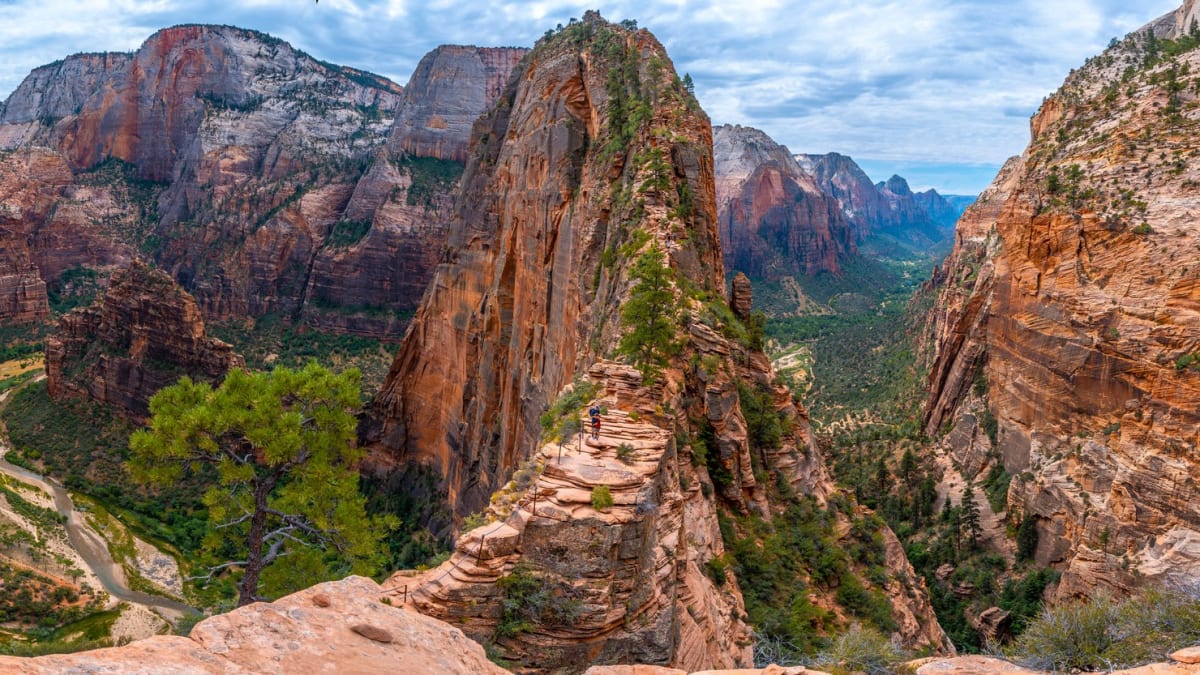
A knife-edge fin of sandstone rising 1,500 feet above Zion Canyon, its final half-mile a chain-assisted scramble along a spine with sheer drops on both sides.
Angels Landing is one of the most famous and most demanding day hikes in the national park system, a climb to the top of a towering sandstone fin that stands about 1,500 feet above the floor of Zion Canyon. The route gains that height fast, first up a paved trail and a tight set of engineered switchbacks, then along a narrow rock spine where steel chains bolted into the stone are the only handhold between the trail and long drops on either side.
The reward at the summit is a view few places can match, straight down the green length of Zion Canyon with the Virgin River winding far below. Because the final ridge is so exposed and so popular, the Park Service now runs a permit lottery for the chained section, a system meant to protect both hikers and the trail. It is a hike that asks for a steady head and good judgment, and rewards them fully.
What Travelers Love
- The heart-pounding final ridge, gripping chains along a narrow spine with the canyon falling away on both sides
- The steep engineered switchbacks of Walter's Wiggles carved into the cliff
- A summit view straight down the length of Zion Canyon to the Virgin River far below
- The sense of achievement that makes it one of the most talked-about hikes in the country
Worth Knowing
- A permit obtained through the park's lottery system is required to hike the final chained section to the summit
- This is a genuinely exposed hike with steep drop-offs and is not suitable for anyone uneasy with heights
- There is no shade on the upper route, so summer heat is serious; start early and carry plenty of water
- The chains can crowd, so wait for oncoming hikers at narrow points and turn back if conditions feel icy or wet
Learn about Angels Landing Trail
The route to the top
The hike begins at the Grotto shuttle stop, crosses the Virgin River, and climbs steadily up a paved trail that hugs the canyon wall. It passes through Refrigerator Canyon, a cool, shaded cleft that offers a welcome break, before reaching Walter's Wiggles, a set of twenty-one tight switchbacks carved into the cliff in the 1920s and named for Zion's first superintendent. These deliver hikers to Scout Lookout, a broad saddle with a big view and a natural turnaround point for those who want it.
From Scout Lookout the trail changes character entirely. The final half-mile follows the exposed spine of the landing, where fixed chains help hikers up and along a ridge that in places narrows to just a few feet wide with sheer cliffs on both sides. It is slow, hands-on travel, made trickier by two-way traffic on the chains, and it is here that a permit is required.
How the permit lottery works
Because the exposed final ridge drew crowds that made the narrow chains dangerous, the Park Service put the chained section behind a permit obtained through a lottery. Anyone who wants to continue past Scout Lookout to the summit must hold a valid permit, while the trail up to Scout Lookout itself remains open to all without one.
The lottery runs in seasonal advance drawings as well as a day-before option, so hikers plan ahead or try their luck the day before a visit. Details and timing shift year to year, so the best move is to check the park's current instructions well before your trip and have a backup plan, since a hike to Scout Lookout alone still delivers a tremendous view.
Hiking it safely
Angels Landing has a real safety record behind its reputation, with falls having occurred over the years, and the exposure is not exaggerated. Hikers who are uneasy with heights, or hiking with young children, are wise to make Scout Lookout their summit and enjoy the same canyon from safer ground.
Timing and weather matter enormously. There is almost no shade on the upper route, so the summer sun turns the rock into an oven by midday, making an early start essential. Wet, icy, or windy conditions make the chains treacherous, and it is always better to turn around than to press on. Steady footing, patience at the crowded pinches, and plenty of water are what carry people up and down safely.
The rock beneath your feet
The fin you climb is Navajo sandstone, the same pale, cross-bedded rock that forms Zion's soaring walls, laid down as an immense field of desert dunes roughly 180 million years ago and later cemented into stone. The sweeping diagonal lines visible in the rock are the fossilized faces of those ancient dunes.
Angels Landing was carved out as the Virgin River and its side canyons cut down through the sandstone, isolating this narrow spur as a freestanding fin high above the canyon floor. The river is still at work far below, and the landing is a snapshot of that slow, patient erosion, a blade of rock left standing while the canyon deepened around it.
Closest Boutels
The closest Boutel™ stays, so you can turn this stop into an overnight. Each is a place we chose through independent editorial review, never a paid placement.
Details
Springdale, UT
Frequently asked questions
What is the Angels Landing trail?
Angels Landing is one of the most famous and thrilling hikes in the United States, a strenuous climb in Zion National Park to a narrow rock fin with breathtaking views over Zion Canyon. The roughly five-mile round-trip hike gains nearly 1,500 feet, and its final half-mile follows a knife-edge spine with chains bolted into the rock to help you along sheer drop-offs on both sides. It is exhilarating for those prepared for it, but genuinely not for everyone.
Do you need a permit to hike Angels Landing?
Yes. Since 2022, a permit is required to hike beyond Scout Lookout onto the chains section, issued only through lotteries on Recreation.gov. There is a seasonal lottery, applied for months in advance, and a day-before lottery, and applying to both for your target date gives the best odds. Weekdays, shoulder seasons, and winter are far less competitive than summer weekends. There are small application and per-person permit fees.
How dangerous is Angels Landing?
The chains section is genuinely dangerous, with a narrow path, steep drop-offs, and a history of fatal falls, so it demands respect. Anyone with a real fear of heights should honestly consider stopping at Scout Lookout, which still offers wonderful views, rather than pushing through anxiety high above the canyon floor. Hike only when the rock is dry and free of ice, hold the chains, take your time, do not crowd others, and turn back if conditions or your comfort say so.
When is the best time to hike Angels Landing?
Spring and fall, roughly March through May and September through November, offer the best combination of moderate temperatures, better permit odds, and safer, dry conditions. Summer is hot and the line for the chains can back up at Scout Lookout, especially in the afternoon, while winter can bring ice that makes the chains hazardous. Start early to beat heat and crowds, and plan four to five hours for the round trip.
Is there a good alternative if I skip the chains?
Absolutely. Hiking to Scout Lookout, the point where the permitted chains section begins, does not require a permit and still rewards you with dramatic views of Zion Canyon after a challenging but far less exposed climb up the switchbacks known as Walter's Wiggles. It is a satisfying turnaround for those uneasy with heights or without a permit, letting you enjoy much of the adventure without the most dangerous, exposed final stretch.
Nearby

The Narrows
2.5 miles away
The Narrows is Zion's signature hike - a route that follows the Virgin River through a slot canyon where the walls are 1,000 feet high and 20 feet apart.

Kolob Canyons
18 miles away
Kolob Canyons is the northwest section of Zion NP, accessed directly from I-15 (Exit 40).