
Valley of Fires Recreation Area
6158 US-380, Carrizozo, NM
Carrizozo, NM
A river of black lava frozen in place across the desert, one of the youngest flows in the country, with a trail that carries you right out onto the ropy rock.
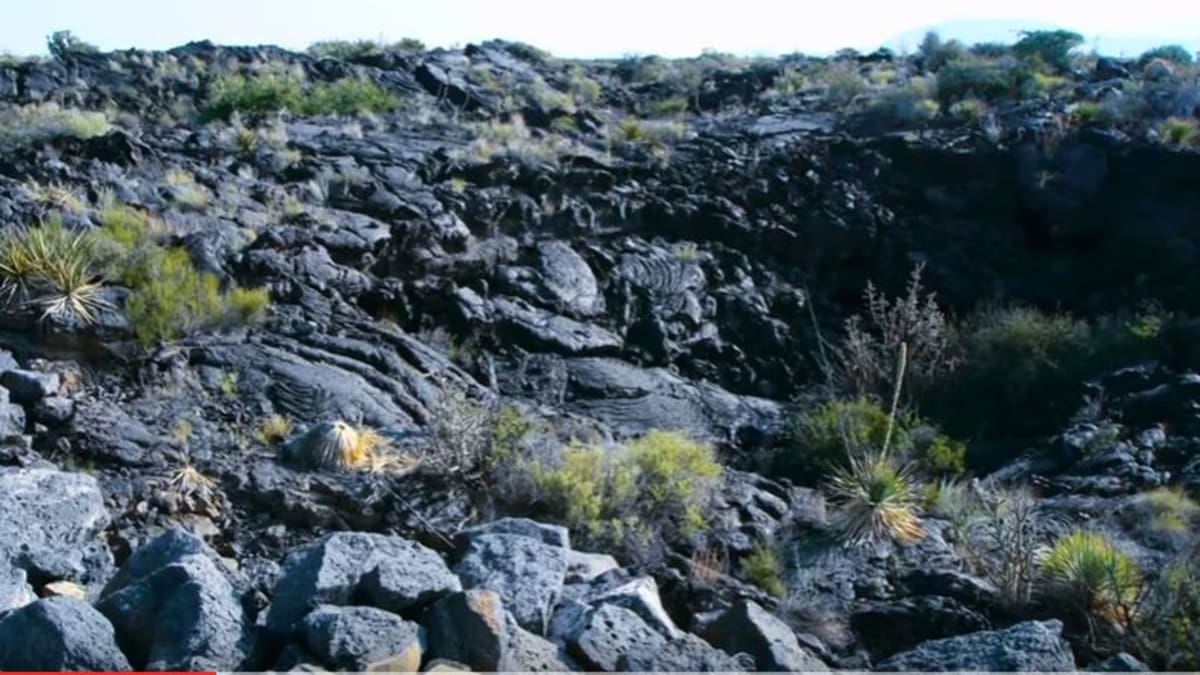
Valley of Fires is a vast field of black lava spread across the floor of the Tularosa Basin, one of the youngest lava flows in the continental United States. Known as the Malpais, Spanish for badland, the flow poured from a vent to the north and spread for miles down the basin, cooling into a frozen river of jagged and ropy black rock that looks as if it might still be warm.
The recreation area sits on a low rise, a kind of island, ringed by the lava, with a paved trail that carries visitors right out onto the flow. Up close the black rock reveals itself in astonishing detail, ropy pahoehoe folds, collapsed bubbles and tubes, and pockets where soil has gathered and hardy desert plants have taken hold. It is a rare chance to walk out onto a lava flow young enough that its every ripple is still sharp.
What Travelers Love
- Walking a paved trail out onto a genuine, jet-black lava flow
- The strange, ropy textures of the pahoehoe lava underfoot
- Hardy plants and wildlife that have colonized the black rock
- Big Tularosa Basin views with Sierra Blanca on the horizon
Worth Knowing
- The black lava absorbs heat and gets very hot in summer, so go early and carry plenty of water
- The rock is sharp and uneven off the trail, so stay on the paved path and wear sturdy shoes
- Watch for rattlesnakes and cactus among the rocks, and keep to the trail
- There is a small campground and picnic area, but services are limited, so fuel and supplies come from Carrizozo
Learn about Valley of Fires Recreation Area
One of the youngest lava flows in the country
The Malpais flow at Valley of Fires is geologically very young, poured out only a few thousand years ago, which makes it one of the freshest lava flows in the continental United States. The lava issued from a vent to the north and ran south down the Tularosa Basin for many miles, following the low ground until it cooled and hardened in place.
Because it is so young, the flow has barely begun to weather. Its surfaces still show the ropy folds of pahoehoe lava, the jagged rubble of aa lava, and the collapsed shells of gas bubbles and lava tubes, textures that older flows lose over time. Walking the trail is like reading the record of the eruption, each fold and blister a frozen moment of the lava's last movement.
Life on the black rock
A lava flow looks lifeless at first glance, but Valley of Fires is quietly full of life. Over thousands of years, wind-blown soil has collected in cracks and hollows, and plants have taken root, junipers, cacti, sotol, and grasses, so the black rock is threaded with green. That vegetation in turn supports a surprising range of wildlife.
The flow is home to lizards, snakes, rodents, and birds, and biologists have noted that some creatures here have evolved darker coloring to blend with the black rock, a subtle adaptation to the malpais. Early morning and evening are the best times to see wildlife stirring, and the interplay of dark stone, desert plants, and animal life makes the flow far more than a barren field of rock.
Walking the flow
A paved, largely accessible trail loops out from the visitor area onto the lava, with interpretive signs that explain the eruption, the rock types, and the plants and animals along the way. Staying on the path matters, since the lava off-trail is sharp, uneven, and hard on ankles and shoes, and the surrounding rock hides snakes and cactus.
The black rock soaks up the sun, so on a summer day the flow can grow blistering hot, making an early start and plenty of water essential. In the cooler months, and in the soft light of morning and evening, the walk is a pleasure, with the textures of the lava thrown into relief and the wide basin opening out beyond the edge of the flow.
The Tularosa Basin and when to go
Valley of Fires is one of a string of remarkable landscapes in the Tularosa Basin. To the south lies the gleaming white gypsum of White Sands, a startling counterpoint to this black lava, and to the east rise the Sacramento Mountains and the high peak of Sierra Blanca. Together they make the basin one of the most geologically varied stretches of the Southwest.
Fall, winter, and spring bring the most comfortable weather for walking the flow, with mild temperatures and clear light. Summer is hot, made hotter by the heat-absorbing rock, so early mornings are best. The nearby town of Carrizozo serves as a base and supply point, a small crossroads community with a growing arts scene along old Route 54.
Closest Boutels
The closest Boutel™ stays, so you can turn this stop into an overnight. Each is a place we chose through independent editorial review, never a paid placement.
Details
Carrizozo, NM
Frequently asked questions
What is the Valley of Fires Recreation Area?
The Valley of Fires Recreation Area, near Carrizozo in central New Mexico, protects a striking and relatively young lava flow known as the Malpais, one of the youngest and best-preserved lava flows in the continental United States. The vast field of black, jagged volcanic rock stretches across the desert, dotted with hardy plants and wildlife that have colonized the rugged terrain. A paved, accessible nature trail winds out onto the lava flow, letting visitors explore the fascinating volcanic landscape up close and learn about its geology and ecology. With its dramatic lava flow, interpretive trail, camping, and unusual scenery, the Valley of Fires Recreation Area offers a distinctive and educational outdoor stop in central New Mexico.
What can you do at the Valley of Fires Recreation Area?
You can walk the paved, partly accessible nature trail that winds out onto the black lava flow, learning about the volcanic geology, plants, and wildlife through interpretive signs, marvel at the rugged, otherworldly terrain, watch for the wildlife that lives among the lava, camp at the campground overlooking the flow, and enjoy the desert scenery and dark night skies. The accessible trail makes the lava flow easy to experience. It is a fascinating stop for those interested in geology and unusual landscapes. With its lava-flow trail, camping, and striking scenery, the Valley of Fires Recreation Area offers an engaging and distinctive outdoor experience in central New Mexico.
What safety tips apply at the Valley of Fires Recreation Area?
While the main nature trail is paved and accessible, the lava rock off the trail is sharp, jagged, and uneven, so stay on the trail, wear sturdy shoes, and use caution, as it is easy to trip or cut yourself on the rough volcanic rock. The desert setting is exposed and can be hot with little shade, so bring water and sun protection, especially in summer. Watch for wildlife like snakes among the rocks. Being careful to stay on the trail, wearing good shoes, and preparing for the sun and heat ensures a safe visit to the lava flow.
When is the best time to visit the Valley of Fires Recreation Area?
Spring and fall offer the most comfortable temperatures for walking the trail and enjoying the lava flow, avoiding the heat of summer, which can be intense on the dark, sun-absorbing rock, and the cold of winter. Morning and evening are pleasant and offer beautiful light on the black lava. The dark skies make clear nights wonderful for stargazing. For the best combination of comfortable weather and enjoyable exploration of the lava flow, aim for spring or fall, or the cooler hours of the day, at the Valley of Fires Recreation Area.
What is near the Valley of Fires Recreation Area?
The Valley of Fires Recreation Area is near Carrizozo in central New Mexico, within reach of the historic town of Lincoln with its Billy the Kid history, the town of Ruidoso in the mountains, the Three Rivers Petroglyph Site, and, farther south, White Sands National Park. That makes the Valley of Fires Recreation Area a distinctive natural stop to combine with Lincoln, Ruidoso, the Three Rivers Petroglyph Site, and the other attractions of central and southern New Mexico on a visit to the state.
Nearby

Three Rivers Petroglyph Site
15 miles away
Three Rivers is a BLM site, not a national park, so it flies under the radar and you may have the ridge nearly to yourself.

Bosque del Apache National Wildlife Refuge
56 miles away
The Bosque del Apache flight decks are the reason birders plan road trips around New Mexico in November.
New Mexico Museum of Space History
57 miles away
This museum sits right where a lot of American rocketry actually happened, since White Sands Missile Range is just over the mountains.

White Sands National Park
64 miles away
The world's largest gypsum dune field, rolling waves of brilliant white sand you can sled down.