
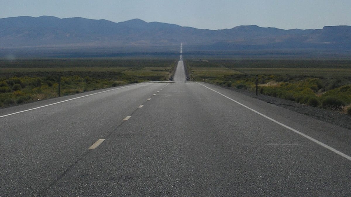
US Route 50, the Loneliest Road in America
US Highway 50, central Nevada
Ely, NV
An empty ribbon of two-lane blacktop crossing range after desert range on the old Pony Express route, so quiet that Nevada turned the insult into a badge of honor.
In July of 1986, Life magazine looked at the long empty stretch of US Route 50 across central Nevada and called it the Loneliest Road in America. The article warned that there were no points of interest along the way and that only drivers confident in their survival skills should risk it. It was meant as a put-down, but Nevada did something clever with it: the state adopted the name as a slogan and printed up a tongue-in-cheek survival guide, and travelers have been chasing the loneliness on purpose ever since.
The truth is that the road is far from empty of interest. It traces one of the great historic corridors of the West, the path of the Pony Express riders and the Overland Stage, across the striking basin-and-range country of the Great Basin. Between Baker at the Utah border and the Sierra near Lake Tahoe, it links a chain of genuine Old West towns and passes within reach of a national park, ghost towns, and Pony Express station ruins. What it does not have is crowds, and that is exactly the point.
What Travelers Love
- Mile after mile of open, uncrowded high-desert driving with almost no traffic
- The dramatic basin-and-range scenery, a new mountain wall rising past every valley
- Real Old West towns strung along the way, from Great Basin's Baker to mining-era Ely, Eureka, and Austin
- Driving the actual path of the Pony Express and the Overland Stage, with station ruins nearby
Worth Knowing
- Services are far apart, so fuel up whenever you can and carry water, snacks, and a spare, especially in summer heat or winter cold
- Cell coverage is patchy to nonexistent across the long stretches between towns, so download maps ahead of time
- Winter can bring snow and ice over the mountain passes, so check road conditions before crossing in the cold months
- Travel Nevada offers a free Highway 50 Survival Guide you can get stamped in the towns along the route, a fun keepsake of the drive
Learn about US Route 50, the Loneliest Road in America
How an insult became a slogan
The Loneliest Road label was born as a warning. Life magazine's 1986 piece described the roughly 287-mile run between Ely and Fernley as a place with no attractions and no reason to stop, and quoted an official suggesting travelers not attempt it at all. It was the kind of write-up that would sink most destinations.
Nevada leaned into it instead. Rather than argue, the state embraced the name, turned it into a marketing campaign, and produced the Official Highway 50 Survival Guide, a passport-style booklet that visitors can carry and get stamped at businesses in the towns along the way. Finish the route with a full set of stamps and you can send it in for a certificate proving you survived the Loneliest Road. It remains one of the more charming pieces of reverse psychology in American tourism.
Basin and range, and the ghosts of the Pony Express
The reason the road feels so lonely is the land itself. Central Nevada sits in the Basin and Range province, where the earth's crust stretched and cracked into a washboard of parallel mountain ranges separated by broad, flat desert valleys. Driving east to west you climb a range, drop into a valley that can run for tens of miles dead straight, then climb the next range and do it all again. The scale is enormous and the emptiness is real.
This same corridor carried some of the most storied traffic in the West. The Pony Express riders galloped their mail relay across here in 1860 and 1861, and the Overland Stage rolled through afterward, with lonely water-and-horse stations spaced a day's ride apart. Ruins and marked sites of several of those stations survive off the highway, so the road you drive today follows almost exactly the line the riders once raced across the desert.
The towns along the way
At the eastern end sits Baker, the tiny gateway to Great Basin National Park, where the Loneliest Road meets one of the least-visited national parks in the country, home to ancient bristlecone pines and the Lehman Caves. West of there the highway rolls into Ely, a town that unusually grew on copper rather than the gold and silver that built its neighbors, and which keeps a working heritage railroad among its attractions.
Farther west come Eureka, often called the friendliest town on the Loneliest Road, with a beautifully preserved 19th-century main street and opera house, and Austin, a compact silver-boom town clinging to a mountainside with historic churches and stone buildings from the 1860s. Beyond them the road runs on through Fallon and Dayton toward Carson City and the Sierra, so the drive strings together a national park, a heritage railroad, and a handful of the best-preserved mining towns in Nevada, all on a single tank-by-tank crossing of the state.
Driving the Loneliest Road
This is a drive to plan a little. Fuel, food, and lodging cluster in the towns and there is very little in between, so top off the tank at every chance, carry water and snacks, and expect long gaps with no cell service. In summer the desert bakes, and in winter snow and ice can close over the passes, so pick your season and check conditions before you set out over the mountains.
Done right, it is one of the great American road trips: unhurried, wide open, and genuinely quiet, the kind of drive where you can pull over on the shoulder, cut the engine, and hear nothing at all. Grab the survival guide, give yourself a full day or two to cross with stops in the old towns, and let the emptiness be the attraction rather than something to hurry through.
Closest Boutels
The closest Boutel™ stays, so you can turn this stop into an overnight. Each is a place we chose through independent editorial review, never a paid placement.
Details
Ely, NV
Frequently asked questions
What is US Route 50, the Loneliest Road in America?
US Route 50 across Nevada, famously dubbed the Loneliest Road in America, is a legendary stretch of highway crossing the vast, empty heart of the state through wide desert basins and mountain ranges, with long distances between small towns. Earning its nickname from the remote, sparsely populated country it traverses, the route offers a quintessential Great Basin road trip past historic mining towns, ghost towns, sand dunes, petroglyphs, mountain passes, and wide-open desert scenery. A memorable journey through the lonely beauty of central Nevada, it appeals to road-trippers seeking solitude and adventure. With its remote desert scenery, US Route 50 offers a spectacular destination in Nevada.
What can you do along US Route 50 in Nevada?
You can take a memorable road trip across the state, stopping at historic mining towns like Ely and Eureka, ghost towns, sand dunes, ancient petroglyph sites, mountain passes, and scenic overlooks, and soak up the vast, lonely Great Basin desert scenery. The historic towns, the desert and mountain scenery, the roadside curiosities, and the sense of solitude and adventure are the draws, making it a classic Nevada journey. Some towns offer a fun passport to stamp along the way. With its historic stops and lonely scenery, US Route 50 offers a rewarding road trip in Nevada.
What should I know before driving US Route 50 in Nevada?
Because US Route 50 crosses very remote country with long distances between towns and services, filling your gas tank at every opportunity, carrying plenty of water, food, and emergency supplies, and checking your vehicle are essential, as cell service is spotty and help can be far away. Watching for wildlife on the road, being prepared for weather from desert heat to mountain snow, and planning your stops help. Coming well-prepared for the remoteness ensures a safe and enjoyable drive on US Route 50, the Loneliest Road in America, in Nevada.
When is the best time to drive US Route 50 in Nevada?
The milder months of late spring through fall offer the most comfortable conditions for the long desert-and-mountain drive, with summer warm in the basins but pleasant in the higher elevations, and fall especially scenic, while winter can bring snow and ice to the mountain passes. Spring and fall balance comfortable weather with clear roads. The remote dark skies are spectacular for stargazing at night. For the best driving conditions, aim for late spring through fall on US Route 50, the Loneliest Road, in Nevada.
What is near US Route 50 in Nevada?
US Route 50, the Loneliest Road, crosses central Nevada, passing near Sand Mountain Recreation Area, Grimes Point petroglyphs, the historic towns of Eureka and Ely with the Nevada Northern Railway, and connecting toward Great Basin National Park to the east and the Reno area to the west. That makes US Route 50 a spectacular route to combine with Sand Mountain, the Nevada Northern Railway, and the other attractions of central Nevada on a visit to the state.
Nearby

Nevada Northern Railway
0.1 miles away
The Nevada Northern Railway was built in 1906 to connect the copper mines of Ely to the transcontinental railroad at Cobre, 140 miles north.

Ward Charcoal Ovens State Historic Park
16 miles away
Ward Charcoal Ovens: free, open year-round. On US-6/50 18 miles south of Ely, then 7 miles on dirt road. Bring a flashlight - the kilns are dark inside. Self-guided interpretive placard at each.
Wheeler Peak Cirque Glacier
36 miles away
Wheeler Peak at 13,063 feet is the second highest point in Nevada and its north face holds a remnant cirque glacier that represents the southernmost glacier in the continental United States.

Great Basin National Park
39 miles away
Ancient bristlecone pines, the Lehman Caves, and some of the darkest night skies in the country.