
Snowy Range Scenic Byway
Wyoming
Most mountain roads make you choose between the valley and the summit. The Snowy Range Scenic Byway hands you both. Following Wyoming Highway 130 west out of the little town of Centennial, the pavement climbs steadily out of the sagebrush foothills, up through dark pine forest, and finally breaks out above the trees into a world of alpine tundra, glassy glacial lakes, and pale quartzite peaks streaked with snow that lingers well into summer. In roughly 29 miles it carries you over 10,847-foot Snowy Range Pass, one of the highest paved crossings in Wyoming.
This is one of the country's original scenic byways, singled out by the US Forest Service back in 1988 as a route worth protecting and celebrating in its own right. From the high overlook at Libby Flats to the mirror-still surface of Lake Marie reflecting Medicine Bow Peak, it packs the feel of a full Rocky Mountain expedition into a short, unhurried afternoon drive. It is the kind of road you remember, and an unforgettable approach to any stay in the Medicine Bow country between Laramie and Saratoga.
Learn about Snowy Range Scenic Byway
The Road
Wyoming Highway 130 is a paved, two-lane state road, and the scenic byway is the roughly 29-mile stretch of it that crosses the Medicine Bow Mountains, the range locals simply call the Snowy Range. The heart of the drive runs between Centennial on the east side and the descent toward Saratoga on the west, entirely within the Medicine Bow National Forest. Driven straight through, the byway itself takes about an hour, though almost no one rushes it.
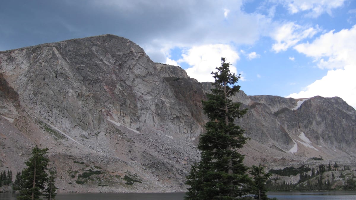
The climb is the whole point. Starting near 8,000 feet at Centennial, the road gains more than 2,000 feet as it works up to Snowy Range Pass at 10,847 feet, high enough that you leave the forest behind entirely and drive across open alpine tundra, the fragile, treeless zone found only on the tops of tall mountains. Up there the air is thin, the weather can turn in minutes, and the glacier-carved quartzite peaks of the Snowy Range rise pale and jagged right beside the car, holding permanent snowfields you can still see glinting in July.
What makes this drive special is how much wild country it opens up with almost no effort. Pullouts and picnic spots dot the high section, short paths lead down to a string of clear glacial lakes, and the trail up 12,013-foot Medicine Bow Peak, the tallest summit in southern Wyoming, begins right off the road near Lake Marie. You can simply cruise through and drink in the views from the car, or park and be walking among wildflowers and marmots within minutes.
How to Get There
The most common way onto the byway starts in Laramie, the university town along Interstate 80 in southeast Wyoming. From Laramie, head west on Wyoming Highway 130 for about 27 miles across the Laramie Valley to reach Centennial, the small town at the eastern foot of the mountains where the true scenic climb begins. Coming from Denver or Cheyenne, you simply follow Interstate 80 to Laramie first, then pick up Highway 130 heading west.
From the west side, the byway is reached from Saratoga, a quiet valley town known for its hot springs and the North Platte River. From Saratoga, take Wyoming Highway 130 east, and the road begins its climb up into the Snowy Range from that direction. Travelers on Interstate 80 farther west can exit at Walcott Junction and follow Highway 130 south through Saratoga to reach the byway's western end.
Either approach delivers the same spectacular crossing, so the choice often comes down to where you are staying. Many drivers like to start from Centennial and climb west so the peaks and lakes unfold ahead of them, then drop down the far side toward Saratoga for the night.
History
Long before it was a scenic drive, this was a working route through the mountains. A wagon road was pushed across the Snowy Range in the 1870s, in the era of mining and timber in the Medicine Bow country, and for decades it was a rough seasonal track. In the 1920s crews widened and smoothed it using horse-drawn equipment, and by the 1930s the road over the pass had been paved, opening the high alpine country to ordinary travelers for the first time.
The route's national moment came in 1988, when the US Forest Service named it a National Forest Scenic Byway. This was among the very first roads chosen under that brand-new federal program, which set out to highlight the most beautiful drives running through the country's national forests, and it is widely described as the second such byway designated in the nation. The honor recognized the Snowy Range Scenic Byway not as a way to get somewhere, but as a destination in its own right, a drive worth taking for the sake of the drive.
It is worth being clear about exactly what that designation is. The Snowy Range Scenic Byway is a Forest Service Scenic Byway, a status created and awarded by the US Forest Service for roads crossing national forest land. That is a distinct honor from the Federal Highway Administration's National Scenic Byway and All-American Road program, which recognizes a separate list of routes. What both share is the same basic idea, a road so remarkable that the country decided it deserved formal recognition and lasting protection.
The peaks that give the drive its drama are far older than any road. The pale, jagged crest of the Snowy Range is built largely of quartzite, an extremely hard rock formed when ancient sandstone was cooked and compressed deep in the earth roughly 1.7 billion years ago. During the last ice age, glaciers ground their way down these slopes, scooping out the basins that now hold Lake Marie, Mirror Lake, and their sister lakes, and carving the sheer headwalls that make Medicine Bow Peak look like a wall of stone. The snowfields that cling to those shaded walls through summer are what gave the whole range its nickname, the Snowies.
Little-Known Facts
- The Snowy Range Scenic Byway is one of the oldest roads of its kind in the country, named a National Forest Scenic Byway by the US Forest Service in 1988 and widely cited as only the second such byway designated in the nation.
- Snowy Range Pass tops out at 10,847 feet, making Wyoming Highway 130 one of the highest paved road crossings in the state, high enough that the road climbs completely above the tree line.
- The route began as a rough wagon road across the mountains in the 1870s, was widened in the 1920s with horse-drawn equipment, and was not fully paved until the 1930s.
- The pale peaks of the Snowy Range are made of quartzite roughly 1.7 billion years old, some of the oldest exposed rock you will ever drive past.
- The clear lakes strung along the high country, including Lake Marie and Mirror Lake, were scooped out by glaciers during the last ice age, not by rivers.
- The range earned its nickname, the Snowies, from the permanent snowfields that cling to its shaded quartzite walls straight through the summer.
- Medicine Bow Peak, reached by a trail that starts right off the byway near Lake Marie, rises to 12,013 feet and is the highest summit in all of southern Wyoming.
- The high overlook at Libby Flats sits above 10,000 feet and, on a clear day, offers views that reach south toward the mountains along the Colorado border.
Along the Route
Centennial
Centennial is the tiny mountain town at the eastern foot of the Snowy Range, where the real scenic climb begins. Sitting near 8,000 feet against the wall of the mountains, it is the last easy place to fuel up, grab a meal, or ask about road and weather conditions before you head over the pass. Small as it is, it makes a friendly launch point for the drive and a handy base for exploring the Medicine Bow country.
Snowy Range Pass
Snowy Range Pass is the high point of the whole byway, cresting at 10,847 feet as the road tops out above the trees. Up here you are driving across open alpine tundra, with the pale quartzite peaks of the Snowy Range rising close on either side and snowfields lingering into summer. It is the highest, wildest stretch of the drive, and the reason the road closes for much of the year.
Libby Flats Observation Point
Libby Flats is the grand overlook of the byway, a stone observation shelter set high above 10,000 feet with a sweeping view in every direction. From here you can look west to Medicine Bow Peak, south toward the distant ranges along the Colorado border, and back east across the Laramie Valley. Interpretive signs help you name the peaks, and it is one of the easiest big views on the whole drive, just steps from where you park.
Lake Marie
Lake Marie is the postcard stop of the Snowy Range, a clear glacial lake cradled right beneath the sheer quartzite wall of Medicine Bow Peak. On a calm morning the water goes perfectly still and mirrors the peak, giving you one of the most photographed reflections in Wyoming, all just a short walk from the roadside parking. It sits above 10,400 feet, so even in summer the air is cool and the alpine wildflowers are at their best.
Mirror Lake
Mirror Lake sits just beside Lake Marie near the top of the drive, a second glacial pool tucked below the peaks. As its name promises, on a still day it lays out a near-perfect reflection of the surrounding quartzite ridges. A picnic area and easy shoreline paths make it a relaxed place to stretch your legs, eat lunch, and watch for the marmots and pikas that live among the high-country rocks.
Medicine Bow Peak Trailhead
The trail to the top of the Snowy Range begins right off the byway near Lake Marie. From here a path climbs to 12,013-foot Medicine Bow Peak, the highest summit in southern Wyoming, passing beneath the range's dramatic headwalls along the way. It is a strenuous, high-altitude hike best left to prepared and acclimated walkers, but even a short stroll up the lower trail rewards you with big views back over the lakes.
Saratoga
Saratoga anchors the western end of the byway, a quiet ranching and fishing town in the North Platte River valley. It is known for its free public hot springs and for some of the best trout water in Wyoming, making it a soothing place to land after the drive down from the high country. Like Centennial on the far side, it offers fuel, food, and a place to rest before or after the mountain crossing.
Details
Centennial and Saratoga
Frequently asked questions
When was the Snowy Range Scenic Byway designated a scenic byway?
The Snowy Range Scenic Byway was designated a National Forest Scenic Byway by the US Forest Service in 1988. It was among the very first roads chosen under that new federal program and is widely described as the second such byway designated in the nation. This is a Forest Service honor for roads crossing national forest land, distinct from the Federal Highway Administration's separate National Scenic Byway program.
How long is the Snowy Range Scenic Byway, and how long does it take to drive?
The scenic byway is the roughly 29-mile stretch of Wyoming Highway 130 that crosses the Medicine Bow Mountains between Centennial and the descent toward Saratoga. Driven straight through, the byway section takes about an hour, but most travelers give it far longer to stop at Libby Flats, Lake Marie, and the many overlooks. The full run from Laramie all the way to Saratoga is roughly 78 miles and takes about two hours without stops.
What are the must-see stops along the Snowy Range Scenic Byway?
Traveling west from Centennial, the highlights include the high overlook at Libby Flats, the crossing of 10,847-foot Snowy Range Pass, and the glacial lakes near the summit, especially Lake Marie and Mirror Lake with their mirror reflections of Medicine Bow Peak. The trailhead for 12,013-foot Medicine Bow Peak, the highest summit in southern Wyoming, also begins right off the road near Lake Marie.
Is the Snowy Range Scenic Byway free to drive?
Yes. The byway is a public state highway, Wyoming Highway 130, so driving it is free and no pass or fee is required. There is no toll and no entrance station. Some developed campgrounds and certain facilities within the Medicine Bow National Forest may charge a use fee, but the drive itself and its roadside overlooks are free to enjoy.
What is the best time of day or year to drive the Snowy Range Scenic Byway?
The high section is typically open from around late May, near Memorial Day, through October, and midsummer brings alpine wildflowers and the warmest, most settled weather. Early morning is the best time to catch Lake Marie and Mirror Lake perfectly still for their famous reflections, and to beat the afternoon mountain thunderstorms that build over the peaks in summer. Fall can be crisp and beautiful before the snow closes the pass.
Is the Snowy Range Scenic Byway open year-round?
No. The high section over Snowy Range Pass closes in winter because of heavy snow. The pass is typically shut from around November until Memorial Day in late May, though the exact dates shift each year with the snowpack. The lower ends near Centennial and Saratoga may stay open, but the high crossing over the pass is a seasonal road, so always check current conditions before you plan a trip over the top.
Do you need four-wheel drive to drive the Snowy Range Scenic Byway?
No. When the byway is open in summer and fall, Wyoming Highway 130 is a paved, well-maintained, two-lane road that an ordinary passenger car handles with ease. Four-wheel drive and high clearance are not needed for the byway itself. They only come into play on the unpaved forest roads that branch off from it, which are a separate matter from the main scenic drive.
What are the winter driving conditions on the Snowy Range Scenic Byway?
In winter the high section over the pass is simply closed to through traffic because of deep snow, so there is no winter crossing of the top. In the shoulder seasons of late spring and fall, when the road is open, sudden snow, ice, and fog can still appear at these high elevations even when it is mild in the valleys. If you drive during those times, watch the forecast, give the road time to be cleared after a storm, and turn back if conditions look poor.
Are there gas stations and services along the Snowy Range Scenic Byway?
Services are limited, so plan ahead. Fuel and food are found in the towns at each end and along the approach, mainly Centennial and Saratoga, with the fuller range of services back in Laramie. Along the high crossing itself there are no gas stations, so fill your tank before you start, carry water and snacks, and pack a warm layer, since the weather at 10,000 feet can be far cooler than in the valley even in summer.
Is there cell phone service on the Snowy Range Scenic Byway?
Cell coverage is spotty and often absent across much of the high country, so do not count on a signal over the pass. It is best to download maps for offline use, tell someone your plans, and treat the drive as a place to disconnect. You are more likely to find service near the towns at either end than up among the peaks and lakes.
Nearby

Snowy Range Scenic Byway
0.3 miles away
The Snowy Range Scenic Byway climbs from Laramie over 10,847-foot Snowy Range Pass through Medicine Bow National Forest.
Como Bluff and the Fossil Cabin
36 miles away
Along old US 30 between Medicine Bow and Rock River runs a long ridge that touched off the fiercest scientific rivalry in American paleontology.
Vedauwoo Rock Formations
47 miles away
Vedauwoo is a sprawl of massive Sherman granite outcrops between Laramie and Cheyenne, formed from the same granite batholith that underlies Hallett Peak in Rocky Mountain National Park.
Abraham Lincoln Memorial Monument
48 miles away
The Lincoln Highway Memorial at the summit of Sherman Pass on I-80 is a 13-foot bronze bust of Abraham Lincoln mounted on a granite pedestal at 8,640 feet - the highest point on the original Lincoln H...