
Palouse Falls State Park
Palouse Falls Rd
LaCrosse, WA
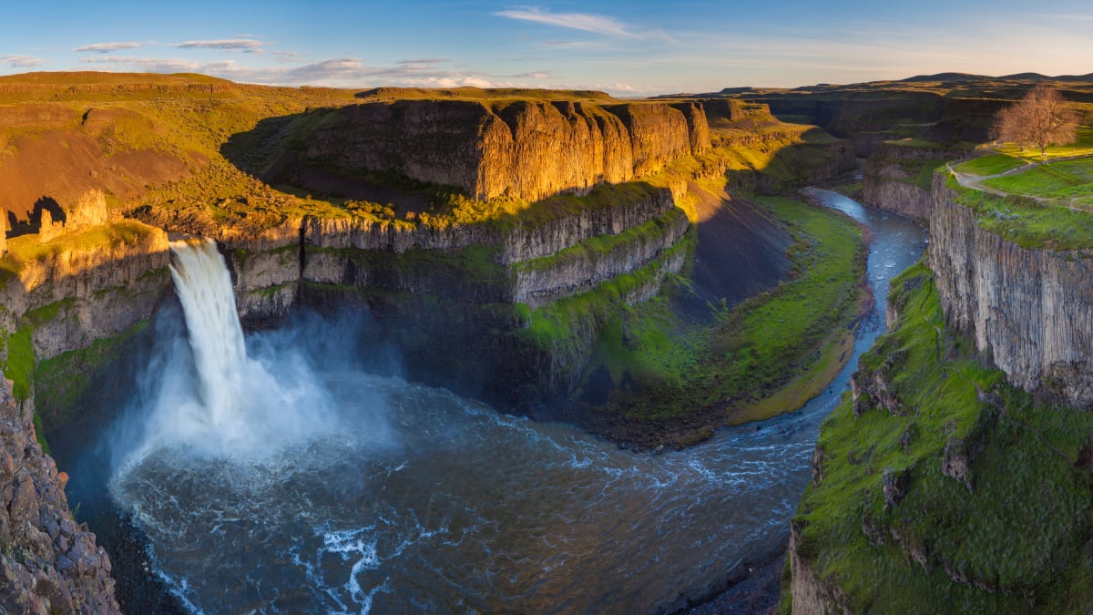
A 198-foot waterfall that pours into a raw basalt amphitheater in the middle of the eastern Washington scablands, the last great survivor of the Ice Age floods.
Palouse Falls is one of those places that seems impossible until you are standing in front of it. You drive across miles of dry, rolling scabland, park in an ordinary lot, walk a few steps, and the ground falls away into a vast basalt bowl where the Palouse River drops 198 feet in a single roaring plunge. In 2014 the state made it official as Washington's state waterfall.
What makes it more than just a pretty cascade is the story written in the rock around it. This whole landscape, and the falls themselves, were carved in a geologic instant by some of the largest floods the planet has ever known, and Palouse Falls is the last major waterfall those floods left behind.
What Travelers Love
- The sudden reveal of a 198-foot waterfall in the middle of open scabland
- The raw basalt amphitheater and canyon the falls have carved
- Spring runoff, when the river is loudest and fullest
- Dark, wide-open skies and a real sense of remoteness
Worth Knowing
- The developed viewpoints are safe, but the unofficial trails to the brink and the base are steep, loose, and have been the site of serious accidents, so stay behind the railings
- Spring brings the fullest flow; by late summer the river runs much lower
- It is hot and shadeless in summer and can freeze hard in winter, so carry water and sun protection
- A Washington Discover Pass is required to park
Learn about Palouse Falls State Park
Carved by the Ice Age floods
At the end of the last Ice Age, a lobe of glacial ice repeatedly dammed a river in what is now Idaho, backing up an enormous body of water called Glacial Lake Missoula. Again and again the ice dam failed, releasing walls of water that swept across eastern Washington in floods of almost unimaginable scale, scouring the soil down to bare basalt and gouging out the maze of dry canyons known as the Channeled Scablands.
Palouse Falls is one of the most dramatic scars those floods left. The floodwaters carved the deep basalt canyon and the plunge amphitheater, rerouting the Palouse River over a new lip of rock. Of all the waterfalls the floods created across the scablands, this is the one that still flows year round, a living remnant of a catastrophe that reshaped the Northwest thousands of years ago.
The falls and the canyon
The falls drop 198 feet into a churning pool ringed by sheer columns of dark basalt, the cooled remains of ancient lava flows that the floods later cut through. Below the plunge the river winds on through a steep, narrow canyon toward its meeting with the Snake River, and the whole scene has the raw, unfinished look of a landscape recently rearranged.
The Palouse people, who lived in this country long before it was a park, knew the falls by their own name, remembered in some sources as Aput Aput, meaning falling water. Their long presence is part of the place, and the falls remain a striking natural landmark on what was once a well-traveled Native route.
When to go, and staying safe
The falls change hard with the seasons. In spring, snowmelt swells the Palouse River and the falls thunder at their fullest; by late summer the flow thins and the canyon bakes. Winter can bring ice and bitter wind. Each season has its own mood, from green spring canyons to golden autumn light on the basalt.
The developed overlooks give safe, spectacular views, and it is important to keep to them. The informal boot paths that scramble to the very brink and down to the base are steep, crumbling, and genuinely dangerous, and people have been badly hurt or killed venturing off the marked areas. The view from behind the railings is the great one anyway.
The scabland country around it
Palouse Falls sits at the edge of two of eastern Washington's signature landscapes. To the north and east rise the rolling, cultivated hills of the Palouse, some of the richest dryland wheat country in the world, their curves catching the light at sunrise and sunset. To the west and south spreads the harder, stranger scabland the floods left bare.
That contrast makes for a memorable drive. The roads out to the falls thread between wheat fields and coulees, and the whole region rewards travelers who like big skies, empty highways, and geology written large across the land.
Closest Boutels
The closest Boutel™ stays, so you can turn this stop into an overnight. Each is a place we chose through independent editorial review, never a paid placement.
Walla Walla Garden Motel
Honorable Mention2279 E Isaacs Ave, Walla Walla, WA
41 miles away|Learn More ›
Details
LaCrosse, WA
Frequently asked questions
What is Palouse Falls State Park?
Palouse Falls State Park, near the town of Washtucna in eastern Washington, protects the spectacular Palouse Falls, a dramatic waterfall that plunges nearly two hundred feet over a sheer basalt cliff into a deep pool amid the rugged canyon of the Channeled Scablands. Carved by the cataclysmic Ice Age floods, the falls and their striking canyon setting make one of the most impressive sights in the state, and Palouse Falls is honored as the official state waterfall of Washington. Viewpoints near the parking area offer stunning views of the falls and canyon. With its dramatic waterfall and geologic grandeur, Palouse Falls State Park is a breathtaking natural destination in eastern Washington.
What can you do at Palouse Falls State Park?
You can take in the spectacular waterfall and canyon from the developed viewpoints near the parking area, which offer stunning, easily accessible views, photograph the falls and dramatic scablands scenery, picnic, and camp at the small campground. The overlooks are the safe and rewarding way to experience the falls. The geologic story of the Ice Age floods adds fascination. Sunrise and sunset light on the canyon can be beautiful. With its jaw-dropping waterfall, canyon scenery, and accessible viewpoints, Palouse Falls State Park offers a breathtaking and memorable stop in eastern Washington, best enjoyed from the designated overlooks.
Is it safe to hike to the base or top of Palouse Falls?
No, this is very important: hiking off-trail to the top or base of Palouse Falls is extremely dangerous and has led to serious injuries and deaths, as the terrain is steep, unstable, and treacherous, and the powerful falls and cliffs are deadly, so visitors should stay on the designated trails and at the developed viewpoints and never attempt to climb down to the water or out onto the cliffs. The safe, official overlooks provide stunning views. Respecting the barriers, staying on the marked trails, and keeping children close are essential for a safe visit to Palouse Falls.
When is the best time to visit Palouse Falls State Park?
Spring is often the best time, when snowmelt and rain make the falls most powerful and dramatic and wildflowers bloom in the scablands, though the falls flow year-round, while summer offers warm weather but the falls may be lower and the exposed canyon hot, so bring water and sun protection. Fall is pleasant, and winter is cold. Morning and evening light can be beautiful on the canyon. For the most powerful falls and lovely scenery, aim for spring, always enjoying the falls from the safe designated viewpoints at Palouse Falls State Park.
What is near Palouse Falls State Park?
Palouse Falls State Park is near Washtucna in eastern Washington, within the Channeled Scablands, within reach of the rolling Palouse farm country with Steptoe Butte, the towns of the region, the Snake River, and the broader Ice Age floods landscape. That makes Palouse Falls State Park a breathtaking stop to combine with Steptoe Butte, the Palouse country, and the other scablands and natural attractions of eastern Washington on a visit to the state.
Outside the Park

Whitman Mission National Historic Site
45 miles away
Whitman Mission National Historic Site preserves the location of the mission established by Marcus and Narcissa Whitman in 1836, the first American settlement in present-day Washington.

Blue Mountains
50 miles away
The dark, blue-hazed forested range that rises straight out of the golden wheat hills southeast of Walla Walla, most of it the public Umatilla National Forest.

Steptoe Butte
55 miles away
Steptoe Butte is a quartzite monolith rising 1,000 feet above the Palouse plateau, a formation of ancient Precambrian rock that predates the Columbia River Basalt Group lava flows that covered most of...