
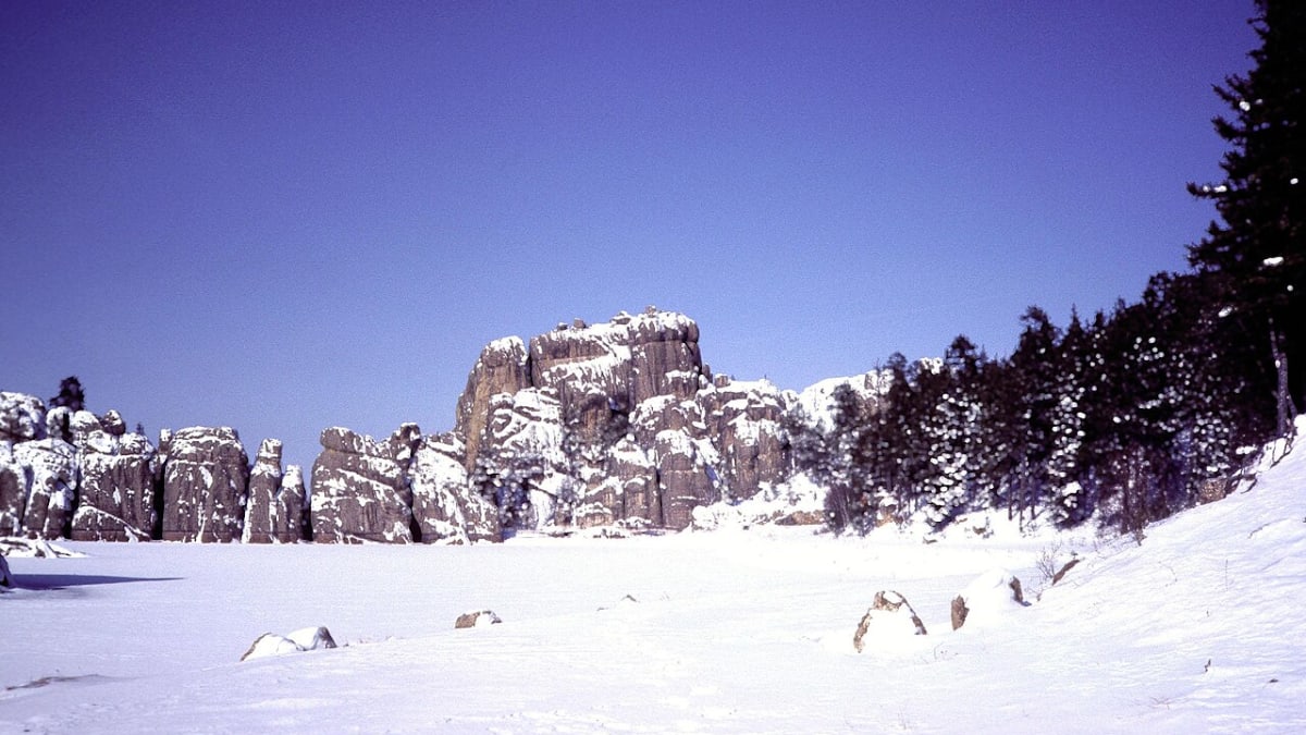
Needles Highway and Sylvan Lake
South Dakota
Needles Highway, South Dakota
Some roads simply carry you through a place. The Needles Highway carries you into one. This is State Route 87, a fourteen-mile mountain road that threads the high granite country of Custer State Park in the Black Hills of South Dakota, past forests of pine and spruce and up among a forest of stone. The needles are tall, thin fingers of rock that rise straight out of the ground like the spires of a cathedral, and the road weaves right between them, squeezing through tunnels blasted by hand through solid granite so narrow that only one car fits at a time.
A former governor and senator named Peter Norbeck laid this route out on foot and horseback, insisting the road hug the most dramatic rock in the hills, and today it forms part of the Peter Norbeck National Scenic Byway, a route the federal government honors for its rare beauty. The drive ends at Sylvan Lake, a small mountain lake ringed by boulders that many people call the crown jewel of the whole park. It is one of the most memorable stretches of road you can drive in America, an unforgettable approach to any stay in the Black Hills.
Learn about Needles Highway and Sylvan Lake
The Road
State Route 87 through the Needles is a narrow, twisting, two-lane mountain road, and it does not pretend to be anything else. It runs about fourteen miles inside Custer State Park, a 71,000-acre preserve that is one of the largest state parks in the country, and it climbs to roughly 6,400 feet in elevation among the granite formations. It is a slow road on purpose. Sharp switchbacks double back on themselves, pigtail curves loop around like a corkscrew, and the pavement bends constantly to fit itself between the rocks rather than blast a straight line through them.
The signature feature is the tunnels. The road passes through several one-lane tunnels cut straight through the granite, and the most famous of them, the Needles Eye Tunnel, is only about eight feet four inches wide. That is barely wider than a single car, which is exactly why large vehicles cannot fit through. The tunnels frame the scenery like a window, and just past the Needles Eye stands the rock spire it is named for, a tall pillar with a slender opening near the top worn through by centuries of wind, rain, and freezing.
What makes the Needles Highway special is how close the stone comes. You do not view these formations from a distant overlook, you drive right up into them, with granite towers pressing in on both sides of the car. Pullouts and small parking areas let you stop and crane your neck at the spires or set out on a trail. And near the northern end the road delivers you to Sylvan Lake, where still water mirrors the boulders and pines, and the trail up Black Elk Peak, the highest summit east of the Rocky Mountains, begins.
How to Get There
The Needles Highway sits in the southern Black Hills, and most travelers reach it from Rapid City, about thirty miles to the north. Coming from Rapid City, take U.S. Route 16 southwest toward the town of Custer, then follow State Route 89 and the park roads into Custer State Park, where State Route 87, the Needles Highway, begins. Many people simply follow signs for Custer State Park and the Needles.
You can drive the Needles Highway in either direction. From the south and east, State Route 87 branches off U.S. Route 16A inside Custer State Park and climbs north into the granite, ending at Sylvan Lake. From the north, near the town of Hill City, you can come in on State Route 87 or connect through State Route 244 near Mount Rushmore, then drop down to Sylvan Lake and drive the Needles from that end.
Because the Needles Highway is one leg of the larger Peter Norbeck National Scenic Byway, many visitors pair it with the byway's other famous roads, especially Iron Mountain Road with its pigtail bridges and framed views of Mount Rushmore, and the park's Wildlife Loop. Together they make a full and unforgettable day of driving in the Black Hills.
History
The Needles Highway was the dream of Peter Norbeck, a South Dakota governor and later United States senator who loved the Black Hills and wanted others to see their most spectacular corners from behind the wheel. Norbeck personally scouted the route through the granite spires, marking the course on foot and on horseback, choosing a path that engineers of the day insisted could not be built. He wanted the road to move through the rock rather than around it, and he was willing to make the road slow and narrow to keep the scenery close.
Construction finished in 1922. Crews cut the roadbed by hand through some of the hardest granite in the region and drilled the one-lane tunnels straight through the stone, work so difficult that the tunnels were kept just wide enough for a single vehicle. The road runs through Custer State Park, which South Dakota had established a few years earlier, and the Needles Highway quickly became the park's showpiece drive, a road built as much to be experienced as to get anywhere.
The Needles Highway later became one leg of the Peter Norbeck Scenic Byway, named in honor of the man who imagined it. That byway, a loop of connected roads that includes the Needles Highway, Iron Mountain Road, and the park's Wildlife Loop, was designated a National Scenic Byway by the United States Department of Transportation in 1996, a federal recognition reserved for roads with outstanding scenic, natural, and historic qualities. The honor placed this hand-built mountain road among a small group of America's most treasured drives.
The rocks themselves are far older than any road. The needles are made of granite that formed deep underground more than a billion years ago, when molten rock cooled slowly beneath the surface. Over immense stretches of time the softer stone above wore away, exposing the harder granite, and then wind, water, and cycles of freezing and thawing carved it into the tall, slender pinnacles that give the highway its name. Sylvan Lake, at the road's end, is younger and man-made, created in 1881 when a dam was built across a mountain stream, and it has drawn visitors and admiring photographers ever since.
Little-Known Facts
- The Needles Highway is part of the Peter Norbeck National Scenic Byway, which was designated a National Scenic Byway by the United States Department of Transportation in 1996, named for the governor and senator who dreamed the road into being.
- Peter Norbeck scouted the entire route himself, marking the course on foot and on horseback, and chose a path through the granite that the engineers of his day said could not be built.
- The Needles Eye Tunnel is only about eight feet four inches wide, barely wider than a single car, which is exactly why RVs, buses, and large trucks cannot pass through it.
- Construction was completed in 1922, and the one-lane tunnels were cut by hand straight through some of the hardest granite in the Black Hills.
- The granite of the needles formed more than a billion years ago, cooling slowly deep underground before wind, water, and frost sculpted it into the tall, slender spires seen today.
- The spire called the Needle's Eye is named for the narrow opening near its top, worn through the solid rock over centuries by wind, rain, and cycles of freezing and thawing.
- Sylvan Lake, at the road's end, is not natural at all. It was created in 1881 when a dam was built across a mountain stream, and it is often called the crown jewel of Custer State Park.
- The trail to Black Elk Peak, the highest point in the United States east of the Rocky Mountains, begins at Sylvan Lake right along the Needles Highway.
Along the Route
Sylvan Lake
Sylvan Lake sits at the northern end of the Needles Highway and is often called the crown jewel of Custer State Park. Though it looks utterly natural, it was created in 1881 by a dam across a mountain stream, and today its still water mirrors the surrounding boulders and pines. A gentle path circles the shore, there is a swim area and parking, and the trailhead for Black Elk Peak, the highest summit east of the Rocky Mountains, begins right here.
Little Devils Tower Trailhead
A short way down the highway from Sylvan Lake, the Little Devils Tower trailhead opens off the road for those who want to trade the car for a while. The trail climbs through pine forest and granite toward one of the best high viewpoints in the Black Hills, with sweeping looks out over the needles and toward Black Elk Peak. It is a steeper, rockier hike than the lakeside strolls, so it rewards hikers who come prepared for a real climb.
Needles Eye Tunnel
The Needles Eye Tunnel is the most famous squeeze on the whole road, a one-lane passage blasted straight through the granite that measures only about eight feet four inches wide. Cars take turns easing through one at a time, and RVs, buses, and large trucks simply cannot fit. Just beyond the tunnel stands the spire it is named for, the Needle's Eye, a tall pillar of rock with a slender opening near its top worn through by centuries of wind and weather.
Cathedral Spires
The Cathedral Spires are a soaring cluster of granite pinnacles that rise together like the towers of a great church, and they are among the most dramatic formations along the highway. A trailhead off the road leads hikers up among the spires for a closer look, while drivers can take in the towers from pullouts along the pavement. This area is so distinctive that it has been recognized as a National Natural Landmark.
The Granite Needles
The needles themselves are the reason the road exists, a whole gathering of tall, thin granite fingers standing on end throughout this stretch of the highway. The road bends and tunnels its way right between them, so the spires press in close on both sides rather than staying off at a distance. Formed from granite more than a billion years old and sculpted by wind and frost, they are also a longtime favorite of rock climbers, who come from around the world to scale their vertical faces.
Details
Custer State Park, Black Hills
Frequently asked questions
Is the Needles Highway a National Scenic Byway?
Yes. The Needles Highway, State Route 87, is one leg of the Peter Norbeck National Scenic Byway, a loop of connected roads through the Black Hills named for the governor and senator who created them. The United States Department of Transportation designated the Peter Norbeck byway a National Scenic Byway in 1996, recognizing its outstanding scenic, natural, and historic qualities.
How long is the Needles Highway, and how long does it take to drive?
The Needles Highway runs about fourteen miles along State Route 87 through Custer State Park, between Sylvan Lake and the junction with U.S. Route 16A. It is a slow, winding mountain road, so even without stopping it takes the better part of an hour to drive. Most visitors give it longer to pause at the tunnels, the spires, and Sylvan Lake.
Can RVs, buses, or large trucks drive the Needles Highway?
No, not through the tunnels. The one-lane tunnels along the highway are extremely narrow, and the famous Needles Eye Tunnel is only about eight feet four inches wide, too tight for RVs, buses, trailers, and large trucks to pass. Before setting out, check your vehicle's width and height against the posted tunnel limits. Large vehicles should plan an alternate route through the park rather than attempt the Needles.
What are the must-see stops along the Needles Highway?
The highlights include Sylvan Lake at the northern end, the one-lane Needles Eye Tunnel and the rock spire it is named for, the soaring Cathedral Spires, and the granite needles that give the road its name. Trailheads for Little Devils Tower and for Black Elk Peak, the highest point east of the Rockies, also open right off the road for those who want to hike.
Is there a fee to drive the Needles Highway?
The Needles Highway runs inside Custer State Park, so a Custer State Park entrance license is required to drive it, the same pass that covers the rest of the park. You can purchase the license at park entrance stations or visitor centers. The pass is good for the whole park, so it also covers the Wildlife Loop and the park's other scenic drives.
When is the best time to drive the Needles Highway?
Late spring through early fall is the season to go, since the road is open then and the weather is mildest, with autumn bringing golden color to the surrounding forest. Early morning and late afternoon offer soft light on the granite and thinner crowds, which helps on such a narrow road. Summer is the busiest time, so an early start makes the drive more relaxed.
Is the Needles Highway open year-round?
No. The Needles Highway closes for the winter, typically from around October or November until April, because of snow and ice on the steep, narrow mountain road. Exact opening and closing dates vary from year to year with the weather, so it is wise to check current conditions with Custer State Park before planning a visit in the colder months.
Do you need four-wheel drive to drive the Needles Highway?
No. When the road is open, the Needles Highway is fully paved, and any passenger car can drive it. There is no need for four-wheel drive or high clearance. What the road asks for instead is patience and care, since it is narrow and winding, with sharp switchbacks and one-lane tunnels where cars must take turns.
What are the driving conditions like on the Needles Highway?
The road is narrow and twisting, with tight switchbacks, pigtail curves, and one-lane tunnels, so the key is to drive slowly and stay alert for oncoming cars. Yield at the tunnels and let vehicles come through one at a time. Watch for hikers, climbers, and rock along the shoulders, and keep an eye out for the park's wildlife, including bison, elsewhere in Custer State Park. During the open season, brief mountain storms can bring rain, so give the pavement time to dry.
Why are the rock formations along the Needles Highway so tall and thin?
The needles are made of granite that formed deep underground more than a billion years ago, when molten rock cooled slowly beneath the surface. Over vast stretches of time the softer stone above wore away, exposing the harder granite. Then wind, water, and endless cycles of freezing and thawing carved the exposed rock into the tall, slender spires, or needles, that line the road today.
Nearby

Needles Highway and Sylvan Lake
0.0 miles away
Needles Highway: SD-87 in Custer State Park, about 14 miles between Sylvan Lake and the junction with US-16A. Requires a Custer State Park entrance license.

Crazy Horse Memorial
3.9 miles away
Crazy Horse Memorial is a mountain in the Black Hills being slowly carved by hand into the likeness of the Lakota leader Crazy Horse on horseback, begun in 1948 and still unfinished.

Mount Rushmore National Memorial
5.0 miles away
Mount Rushmore National Memorial holds the 60-foot carved faces of four presidents in the granite of the Black Hills.

George S. Mickelson Trail
6.6 miles away
A 109-mile crushed-limestone rail-trail following the old Burlington railroad grade through the heart of the Black Hills, from Edgemont to Deadwood.
Cosmos Mystery Area
8.4 miles away
Cosmos Mystery Area: on US-16 a few miles south of Rapid City toward Keystone. Admission charged, guided tour only, so you go in a group when a guide is free.

Custer State Park Wildlife Loop Road
10 miles away
Custer State Park Wildlife Loop Road: 18-mile loop off US-16A in the southern Black Hills. Requires a park entrance license, valid for the day.
Bear Country USA
15 miles away
Bear Country USA: on US-16 about eight miles south of Rapid City on the way to the monuments. Admission is per vehicle.
Reptile Gardens
17 miles away
Reptile Gardens: on US-16 about 6 miles south of Rapid City. Admission charged. Best for ages 4 and up.

Chapel in the Hills
18 miles away
Chapel in the Hills: off Chapel Lane on the west side of Rapid City, tucked into the pines. The grounds are free to walk, with donations welcomed, and the chapel is usually open in the warmer months.
Wind Cave boxwork
20 miles away
Wind Cave National Park: the visitor center is off US-385 north of Hot Springs, and the cave can only be seen on a ranger-led tour, so tickets can sell out on summer days.

Wind Cave National Park
20 miles away
One of the world's longest and most complex caves, famous for its rare honeycomb boxwork formations.
Spearfish Canyon Scenic Byway
34 miles away
Spearfish Canyon Scenic Byway: US-14A between Spearfish and Cheyenne Crossing, about 22 miles. Free, open year-round though winter conditions can close sections.