
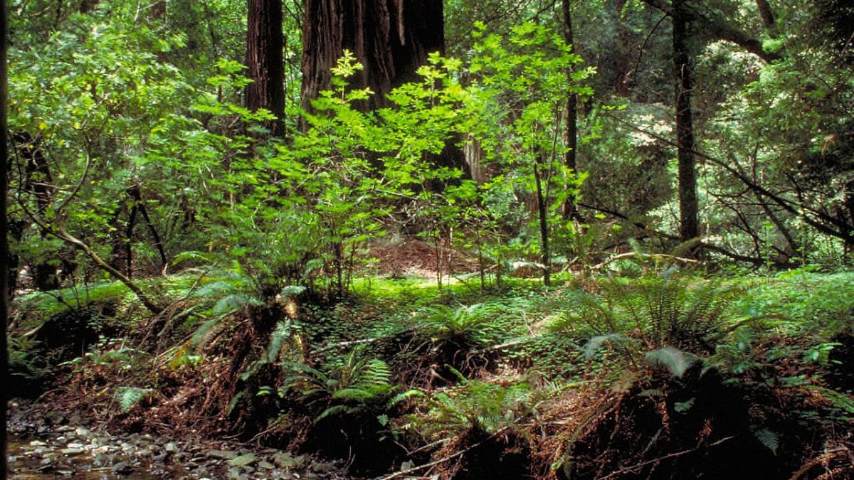
Muir Woods National Monument
1 Muir Woods Road
Mill Valley, CA
A last stand of ancient coast redwoods a short drive from San Francisco, where 250-foot trees turn a canyon into a green, hushed cathedral.
Muir Woods protects one of the last stands of old-growth coast redwoods near San Francisco, trees that were already old when Europeans first reached California. Coast redwoods are the tallest living things on earth, and here the biggest top 250 feet, with a few well over a thousand years old.
Almost every other accessible redwood grove near the bay was logged in the nineteenth century to build and rebuild the booming city. Muir Woods survived because its canyon was too steep and awkward to reach easily, and then because a few people chose to save it. Today a flat boardwalk lets anyone walk straight into the heart of an ancient forest.
What Travelers Love
- Walking the flat boardwalk loop beneath redwoods that top 250 feet, necks craned the whole way
- The deep hush and cool green light, a world apart from the city so close by
- Redwood Creek running clear through the grove, with coho salmon in winter
- Cathedral Grove, where the tallest, oldest giants stand in a natural amphitheater
Worth Knowing
- Parking is limited and now requires a reservation in advance, so book before you go
- The main valley trail is a flat, easy boardwalk; longer loops climb the canyon walls for solitude
- It is cool and damp under the canopy even on warm days, so bring a layer
- Stay on the trails and boardwalks; the shallow redwood roots and the salmon stream are fragile
Learn about Muir Woods National Monument
How the woods were saved
By the early 1900s this canyon, then called Redwood Canyon, was one of the last uncut redwood groves on the coast near San Francisco, and a water company had its eye on damming the creek. In 1905 a wealthy conservationist named William Kent and his wife Elizabeth bought the land to keep it from being logged and flooded.
When the water company moved to seize the land anyway, Kent donated it to the federal government, and in 1908 President Theodore Roosevelt declared it a national monument, one of the first created to protect a natural feature rather than a ruin. Kent asked that it be named not for himself but for John Muir, the great naturalist, who called the gift one of the finest acts of its kind he had ever heard of.
How a redwood forest works
Coast redwoods live only in a narrow strip along the northern California coast, and they depend on fog. Through the dry summer, when it barely rains, the tall trees comb moisture out of the drifting fog, watering themselves and the ferns below. A single tree can pull hundreds of gallons of water from the air.
Redwoods are also nearly fireproof, wrapped in thick, spongy bark, and they resprout from their roots and even from fallen trunks, so a grove can regenerate itself for thousands of years. The forest floor is a soft world of sword fern, redwood sorrel, and fallen giants slowly returning to soil, all in the dim green light that filters down through the canopy far overhead.
The Coast Miwok homeland
This land is the homeland of the Coast Miwok, who lived across what is now Marin County for thousands of years, fishing the creeks and coast and gathering acorns from the oaks on the sunnier slopes. The redwood canyons were part of a landscape they knew intimately.
The Coast Miwok are today part of the Federated Indians of Graton Rancheria, a living community, not a memory. Their long presence here is part of the story of these woods, which were never truly empty wilderness but a homeland.
Wildlife of the canyon
Redwood Creek runs the length of the monument, and in late fall and winter, when the rains raise the water, coho salmon and steelhead return from the ocean to spawn in the same gravel where they hatched, one of the last runs of its kind so close to a major city.
Overhead, northern spotted owls nest in the old growth, and Pacific wrens, Steller's jays, and the occasional pileated woodpecker move through the canopy. Black-tailed deer, gray squirrels, and banana slugs, the bright yellow mascots of the redwood floor, are the easiest wildlife to spot on a walk through the grove.
When to go and how
Muir Woods is cool and green year-round. Winter brings the fullest creek and the returning salmon; spring adds wildflowers and birdsong; summer is busiest, with coastal fog keeping the grove cool. Early morning and late afternoon are the quietest and most beautiful times, when the crowds thin and the light slants low.
Because parking is limited, a reservation is required in advance, and a shuttle runs from nearby park-and-ride lots in the busy season. Combine a visit with the coast at Muir Beach or the summit of Mount Tamalpais for one of the best half-days anywhere near the bay.
Closest Boutels
The closest Boutel™ stays, so you can turn this stop into an overnight. Each is a place we chose through independent editorial review, never a paid placement.
Details
Mill Valley, CA
Frequently asked questions
What is Muir Woods National Monument?
Muir Woods National Monument, just north of San Francisco in Marin County, protects a magnificent old-growth coast redwood forest, home to some of the tallest living things on Earth. Walking beneath these ancient, towering trees, some over a thousand years old, along peaceful streamside trails is a serene and awe-inspiring experience. Named for the famed naturalist John Muir, this cool, shaded cathedral of redwoods offers an easily accessible taste of the primeval forests that once covered much of the California coast, making it one of the Bay Area's most treasured natural sanctuaries.
Do you need reservations to visit Muir Woods?
Yes, this is essential to know: because parking is extremely limited and the monument is very popular, reservations are required in advance for either a parking spot or a shuttle to Muir Woods, and you cannot count on simply driving up and finding space. You must book your parking or shuttle reservation ahead of time online. Planning this in advance is the single most important step for visiting, so secure your reservation before you go to avoid being turned away at this beloved but access-controlled site.
What can you do at Muir Woods National Monument?
You can stroll the main paved and boardwalk loop trails that wind among the giant redwoods along Redwood Creek, an easy and accessible walk, or venture onto longer, hillier trails that climb into the surrounding forest for more solitude and views. Interpretive signs share the ecology and history of the redwoods. The visitor areas offer information and a cafe and gift shop. Whether you take a short, gentle loop or a longer hike, wandering beneath the ancient trees in the hushed, green setting is the heart of the experience.
What should I know before visiting Muir Woods?
Besides the required parking or shuttle reservation, know that the forest is cool, damp, and shaded even in summer, so bring layers, and that cell service is minimal, so plan ahead. The main trails are accessible and stroller-friendly, while side trails are steeper. Arriving earlier in the day means fewer crowds and a more peaceful experience. To protect the fragile forest, stay on the trails and boardwalks. Coming prepared with a reservation, layers, and realistic expectations about crowds makes for a smooth and rewarding visit.
What is near Muir Woods National Monument?
Muir Woods is in Marin County just north of San Francisco, near the coastal town of Sausalito, Mount Tamalpais State Park with its sweeping views, Muir Beach, and the Marin Headlands overlooking the Golden Gate Bridge, with San Francisco itself a short drive south. That makes Muir Woods an easy and inspiring stop to combine with Sausalito, Mount Tam, the Marin coast, and the many attractions of San Francisco and the Bay Area on a Northern California visit.
Nearby

Bay Model Visitor Center
4.0 miles away
The Bay Model in Sausalito is a 1.5-acre working hydraulic model of the San Francisco Bay and Sacramento-San Joaquin Delta, built by the Army Corps of Engineers between 1957 and 1963 to test how engin...

Vista Point
7.1 miles away
Vista Point on the Marin side of the Golden Gate Bridge is the most reliable quick stop for a full-span view of the bridge and the bay.

Palace of Fine Arts
9.7 miles away
A grand and romantic monument in San Francisco's Marina District, a great domed rotunda and sweeping colonnade of golden classical architecture set beside a tranquil lagoon.

Alcatraz Island
9.9 miles away
The Rock, a rocky island in San Francisco Bay that held the most notorious federal prison in America from the 1930s to the 1960s, locking away dangerous inmates like Al Capone behind cold water famed...
Harvey Milk Plaza
12 miles away
A small public plaza at the gateway to San Francisco's Castro, at Castro and Market, named for Harvey Milk, one of the country's first openly gay elected officials.

Twin Peaks
12 miles away
San Francisco's great free overlook, a pair of grassy hills over 900 feet high near the city's center.

Dolores Park
13 miles away
A sunny fourteen-acre hillside lawn at the western edge of San Francisco's Mission District, where the whole city seems to gather on a warm day beneath a palm-lined view of the downtown skyline.
Point Reyes National Seashore
16 miles away
Point Reyes National Seashore covers 71,000 acres of the Point Reyes Peninsula in Marin County and has no entrance fee.

San Francisco Bay
17 miles away
San Francisco Bay is a drowned river valley that formed when rising sea levels after the last glaciation flooded the interior valleys of central California.