
Massacre Rim Wilderness Study Area
Washoe County, Nevada
Vya, NV
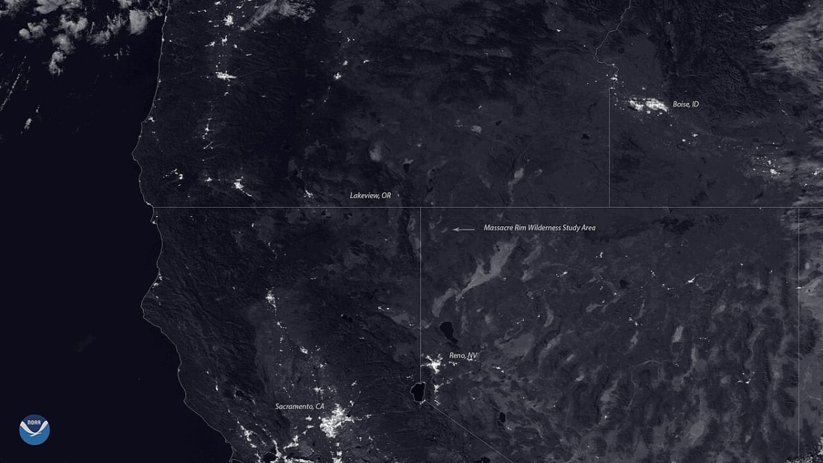
One of the darkest places left in the lower forty-eight, a roadless sea of sagebrush where on the clearest nights the Milky Way can cast a shadow.
Massacre Rim is one of the darkest places left in the country, a wide, roadless stretch of high-desert sagebrush in the far northwest corner of Nevada. It is a Wilderness Study Area, protected as it is by the Bureau of Land Management, and in 2019 it was certified as a Dark Sky Sanctuary, a title given only to the darkest and most remote night skies on Earth. Out here there are no towns for miles, no streetlights, and almost nothing to break the silence.
The land is classic Nevada basin-and-range country: broad valleys of sagebrush between long volcanic plateaus, with a fault-block escarpment, the rim itself, rising along the western edge. From the high ground you can see for tens of miles across empty country. Pronghorn and wild horses range the flats, sage grouse dance in spring, and raptors ride the wind above the escarpment.
But the reason people make the long drive is what happens after dark. With no artificial light for miles, the sky here is about as black as skies get, and the stars come out in numbers that can be hard to believe. On the clearest, moonless nights the glowing band of the Milky Way can actually cast a faint shadow on the pale ground, and you can watch satellites drift silently across the black overhead.
What Travelers Love
- One of the darkest skies in the entire lower forty-eight states, where the Milky Way can cast a faint shadow
- A vast roadless country of sagebrush and long escarpments, empty and silent in every direction
- Wildlife of the high desert, from pronghorn and sage grouse to wild horses
- The rare, complete solitude of a place with no towns, no services, and almost no other people
Worth Knowing
- There are no facilities of any kind here, so bring all your own water, food, fuel, and shelter and pack out everything
- The interior is roadless and the access roads are dirt and gravel, so a high-clearance vehicle is strongly advised and 4WD helps
- There is no cell service, so tell someone your plans and carry a paper map before you head out
- The roads can turn impassable when wet, so pick dry weather and check conditions before committing to the drive in
Learn about Massacre Rim Wilderness Study Area
About as dark as it gets
Stargazers rate how dark a sky is on a scale from one to nine, called the Bortle scale, where a bright city is a nine and the darkest wild places are a one. Massacre Rim rates a one, the very darkest end of the scale, and it is measured as one of the darkest spots in the entire lower forty-eight states. On a clear night here the difference from a city sky is staggering: thousands upon thousands of stars, the Milky Way blazing overhead, and meteors streaking through in season.
The darkness comes from pure distance. There is simply nothing out here to make light, no town, no highway, no ranch cluster close enough to matter. That is what earned Massacre Rim its Dark Sky Sanctuary title, and it is why serious skywatchers treasure it. On the very clearest, moonless nights, the Milky Way glows brightly enough to throw a shadow, something almost no one alive has ever seen.
A roadless high desert
Massacre Rim sits in the basin-and-range country that covers much of Nevada, where the crust long ago stretched and cracked into parallel mountain walls and flat valleys between. Here that pattern shows as broad sagebrush plateaus lifted above wide valley floors, with the rim, a fault-block escarpment, rising along the western edge and dropping steeply to the valley below.
The interior is essentially roadless, a rare thing even in the empty West, which is part of why it was set aside as a wilderness study area. Sagebrush stretches to the horizon, dotted with scattered juniper, and from the higher ground the views run for many miles across country almost untouched by roads or buildings. Walking here means quiet, distance, and the kind of open space that has grown scarce.
Life in the sagebrush sea
The sagebrush that covers Massacre Rim looks plain at a glance, but it is one of the West's important habitats, and much of this land is prized ground for the greater sage grouse, a bird known for its strange, bubbling springtime courtship dances. Pronghorn, the fastest land animal in North America, range the open flats, and mule deer move through the higher country.
Wild horses roam here too, and raptors like hawks, falcons, and golden eagles hunt along the escarpment and ride the updrafts off the rim. Smaller creatures fill in the rest, from rabbits to coyotes to the rattlesnakes that warn you to watch your step. It is a spare kind of abundance, the sort tuned to a dry, windswept land, and it shares the country with almost no one.
The long way in
Reaching Massacre Rim takes planning and a willingness to be truly on your own. It lies well north of Reno, and the nearest places with fuel and food are small towns and ranch settlements many miles away, like Cedarville just over the California line. The way in follows dirt and gravel roads, passable in a passenger car when dry but far better traveled in a high-clearance vehicle, with the interior side routes calling for four-wheel drive.
There are no facilities out here at all: no water, no restrooms, no lights, and no cell service. That means bringing everything you need, telling someone your plans, carrying a paper map, and picking dry weather, since the roads can turn to mud after rain. Come ready to be self-reliant, and Massacre Rim gives back one of the deepest, darkest, most star-filled skies anywhere in the country.
Closest Boutels
The closest Boutel™ stays, so you can turn this stop into an overnight. Each is a place we chose through independent editorial review, never a paid placement.
Details
Vya, NV
Frequently asked questions
What is the Massacre Rim Wilderness Study Area?
The Massacre Rim Wilderness Study Area, in the remote high desert of northwestern Nevada, is a vast, empty, and pristine wilderness renowned for having some of the darkest night skies in the entire country, designated an International Dark Sky Sanctuary, one of only a handful in the world. Far from any city lights, this rugged expanse of sagebrush plateaus, rocky rims, and open desert offers extraordinary solitude and, above all, breathtaking stargazing under skies so dark the Milky Way casts shadows. A remote sanctuary for those seeking true wilderness and pristine dark skies, it rewards the well-prepared. With its pristine dark skies and wilderness, the Massacre Rim Wilderness Study Area offers a spectacular destination in Nevada.
Why is Massacre Rim so good for stargazing?
Massacre Rim is renowned for stargazing because its extreme remoteness, far from any significant source of light pollution, combined with the dry desert air and high elevation, gives it some of the darkest night skies measured anywhere in the country, earning it status as an International Dark Sky Sanctuary, among the most protected dark-sky designations in the world. Under these pristine skies, the Milky Way blazes with astonishing brilliance and countless stars fill the darkness. This exceptional, protected darkness makes the Massacre Rim Wilderness Study Area a premier stargazing destination in Nevada.
What should I know before visiting the Massacre Rim Wilderness Study Area?
Massacre Rim is extremely remote wilderness with no services, facilities, or reliable cell signal, reached by rough, unpaved roads, so a suitable high-clearance vehicle, a full gas tank, ample water, food, warm layers, navigation tools, and telling someone your plans are essential for safety. Being fully self-sufficient and prepared for the isolation, rough terrain, and cold desert nights is critical, as help is far away. For stargazing, a red flashlight and warm clothing help. Coming fully prepared and self-reliant ensures a safe visit to the Massacre Rim Wilderness Study Area in Nevada.
When is the best time to visit the Massacre Rim Wilderness Study Area?
The milder months of late spring through fall offer the most comfortable conditions for the remote desert visit and stargazing, avoiding the harsh cold and potentially impassable roads of winter, while clear, moonless nights any season offer the darkest skies, so checking the moon phase and weather is key for stargazing. Summer nights are warmest for comfortable stargazing. For the best combination of access and dark skies, aim for a clear, moonless night from late spring through fall at the Massacre Rim Wilderness Study Area in Nevada.
What is near the Massacre Rim Wilderness Study Area?
The Massacre Rim Wilderness Study Area is in the remote high desert of far northwestern Nevada, within reach of the vast open country of the region, the routes toward Gerlach and the Black Rock Desert with Fly Geyser to the south, and the northwestern Nevada wilderness. That makes the Massacre Rim Wilderness Study Area a spectacular stop for the well-prepared to combine with the remote attractions of northwestern Nevada on a visit to the state.
Nearby

Fly Geyser
58 miles away
Fly Geyser stands on Fly Ranch, about 20 miles north of Gerlach on the southern rim of the Black Rock Desert.