

Little River Canyon National Preserve
4322 Little River Trail #100, Fort Payne, AL
Fort Payne, AL
A river that flows for most of its length along the top of a mountain has cut one of the deepest canyons in the eastern United States here, plunging over falls and sandstone bluffs.
Little River Canyon is one of the deepest and most rugged canyons east of the Mississippi River, a sandstone gorge cut into the top of Lookout Mountain in the far northeast corner of Alabama. What makes it so unusual is the river that carved it: the Little River runs for most of its length along the very top of a mountain rather than in a valley, then slices down through the plateau to form the canyon.
The preserve protects the canyon, the river, and the forested plateau around it, along with waterfalls, sandstone bluffs, and swimming holes. A scenic drive follows the western rim past a string of overlooks, and trails drop into the gorge for those who want to reach the water. It is wild, quiet country, a slice of the southern Appalachians tucked into a state better known for its coast and its cities.
What Travelers Love
- The long rim drive with pull-offs looking straight down into the gorge
- Little River Falls plunging over its ledge near the canyon's head
- Swimming holes and boulder-hopping along the river in warm weather
- Fall color spilling down the sandstone walls in October and November
Worth Knowing
- The river is powerful and rocky; water levels and currents change fast, so respect posted conditions before swimming or paddling
- Trails into the canyon are steep and rugged, and rock can be slick when wet
- The rim drive is winding and narrow in places, so take it slowly
- Whitewater paddling here is for the experienced only, and depends heavily on rainfall
Learn about Little River Canyon National Preserve
A river on top of a mountain
The Little River is a rare thing in the Appalachians. Fed by rain on the broad, flat top of Lookout Mountain, it gathers and flows for miles across the plateau before it starts to cut down, which is why it is often described as one of the longest mountaintop rivers in the country. As it drops off the plateau it plunges over Little River Falls and enters the canyon proper.
From there the river has spent millions of years grinding down through the hard sandstone of the mountain, carving a gorge that reaches hundreds of feet deep in places. The rim overlooks let you stand at the top of those walls and look down at the water threading among giant boulders far below, a view that feels more like the mountain West than the Deep South.
The Cherokee country and Fort Payne
This corner of Alabama was Cherokee land, part of the homeland the Cherokee held across the southern Appalachians until the forced removals of the 1830s along the Trail of Tears. The nearby town of Fort Payne takes its name from a fort built during that period, and the Cherokee heritage of the region is remembered in local history and place names.
In later years Fort Payne became known for two very different things: a boom as a hosiery-mill town, once billing itself as the Sock Capital of the World, and as the hometown of the country band Alabama. Today it serves as the gateway town to the canyon, a base for exploring the plateau, the falls, and the deep gorge just to the east.
Waterfalls, trails, and the river
The signature sight is Little River Falls, where the river drops over a broad sandstone ledge near the head of the canyon, reachable by a short walk from the parking area. Downstream, the rim drive strings together overlooks with sweeping views into the gorge, and side trails and pull-offs lead to smaller falls and to points where you can scramble down toward the water.
Below the falls, the river fills with boulders and pools that draw swimmers, waders, and boulder-hoppers in warm weather, while whitewater paddlers run the more challenging stretches when rain brings the river up. The trails that descend into the canyon are steep and rocky, rewarding the effort with a river-level view of walls that tower overhead.
Wildlife, the plateau forest, and the seasons
The plateau and canyon are cloaked in southern Appalachian hardwood forest, with oaks, hickories, pines, and mountain laurel clinging to the sandstone. White-tailed deer, wild turkey, foxes, and a rich mix of songbirds live in the woods, hawks and vultures ride the updrafts over the gorge, and the river holds fish, turtles, and salamanders. Spring wildflowers bloom along the rim, and rare plants cling to the bluffs.
Spring brings full waterfalls and blooming laurel and dogwood. Summer is warm and green, the season for cooling off in the river's pools, though flows drop in dry spells. Fall is the showpiece, when the hardwoods turn and color pours down the canyon walls, drawing leaf-lookers to the overlooks. Winter is quiet and stark, with bare trees opening long views and cold, high water thundering over the falls after a storm.
Closest Boutels
The closest Boutel™ stays, so you can turn this stop into an overnight. Each is a place we chose through independent editorial review, never a paid placement.
Details
Fort Payne, AL
Frequently asked questions
What is Little River Canyon National Preserve?
Little River Canyon National Preserve, atop Lookout Mountain near Fort Payne in northeastern Alabama, protects one of the deepest and most spectacular canyons in the eastern United States, carved by the Little River, which flows almost entirely along the top of a mountain. The preserve offers dramatic canyon overlooks, waterfalls including the scenic Little River Falls, a scenic rim drive, hiking trails, and opportunities for swimming and paddling in the river, all amid rugged forested beauty. A stunning natural treasure of Alabama's mountain country, it rewards scenic drivers, hikers, and nature lovers. With its deep canyon and waterfalls, Little River Canyon National Preserve offers a spectacular destination in Alabama.
What can you do at Little River Canyon National Preserve?
You can drive the scenic rim road to a series of dramatic canyon overlooks, view waterfalls including Little River Falls, hike the trails, picnic, and, in appropriate spots and conditions, swim or paddle in the river. The deep canyon views, the waterfalls, the scenic drive, and the rugged forested scenery are the highlights, offering a spectacular and varied experience. The overlooks make the beauty accessible, while trails and the river reward the more adventurous. With its canyon, waterfalls, and drives, Little River Canyon National Preserve offers a rewarding experience in Alabama.
Is Little River Canyon National Preserve safe to visit?
The overlooks and scenic drive are enjoyed safely with care, but the canyon terrain is rugged and demands caution, as cliff edges have steep, dangerous drops, so staying behind railings and back from the rims, on marked trails, and watching children closely are essential. Swimming and wading in the river carry real risks, including slippery rocks, strong currents especially after rain, cold water, and hidden hazards, and there have been drownings, so entering the water only in safe, appropriate spots and conditions, never near the tops of waterfalls, and heeding all warnings are critical. Respecting the cliffs and water ensures a safe visit to Little River Canyon National Preserve in Alabama.
When is the best time to visit Little River Canyon National Preserve?
Spring is spectacular, when rains swell the waterfalls and wildflowers bloom, while fall brings brilliant color to the canyon, a favorite season for the overlooks and drives, and summer offers warm weather when some visitors carefully enjoy the river, though water hazards remain. The waterfalls are fullest in the wetter months. For powerful waterfalls aim for spring, or visit in fall for stunning canyon color, always respecting the water and cliff hazards, at Little River Canyon National Preserve in Alabama.
What is near Little River Canyon National Preserve?
Little River Canyon National Preserve is atop Lookout Mountain near Fort Payne in northeastern Alabama, within reach of the Sallie Howard Memorial Chapel near Mentone, DeSoto State Park, Noccalula Falls in Gadsden, and Cheaha State Park with Bunker Tower to the south. That makes Little River Canyon National Preserve a spectacular stop to combine with the Lookout Mountain area, Noccalula Falls, and the other attractions of northeastern Alabama on a visit to the state.
Nearby
Sallie Howard Memorial Chapel
4.6 miles away
This one stops you in your tracks: a little stone chapel built right around a boulder the size of a truck, which bursts through the back wall and rises up behind the pulpit.

Cloudland Canyon State Park
28 miles away
A thousand-foot gorge sliced into the western edge of Lookout Mountain, with two thundering waterfalls at the bottom and long, layered views along the rim.
Noccalula Falls Overlook
37 miles away
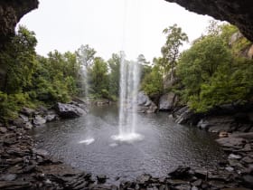
For a big waterfall you can reach in minutes, stop at Noccalula Falls in Gadsden.