
Canyon Rim Trail
Twin Falls Visitor Center, 2015 Nielsen Point Pl
Twin Falls, ID
A paved rim-top walk along a nearly 500-foot river canyon, past the bridge daredevils leap from and on toward a waterfall taller than Niagara.
The Snake River carves a startling canyon across the flat farmland of southern Idaho, a sudden chasm nearly five hundred feet deep and hundreds wide, and the Canyon Rim Trail runs right along its lip. Paved, mostly level, and open to walkers, runners, and cyclists, the path traces the south rim on the edge of Twin Falls, so that at nearly every step you look straight down into the great gorge, the green river winding along its floor, and the sheer basalt walls dropping away beneath your feet.
It is a rim walk stacked with drama. The trail passes directly beside the Perrine Bridge, which vaults the canyon high above the water and draws BASE jumpers from around the world, and it runs past the earthen ramp where Evel Knievel tried to rocket across the canyon in 1974. Follow it far enough east and it aims toward Shoshone Falls, a wall of whitewater taller than Niagara. Few paved paths in the West pack this much spectacle into a level stroll.
What Travelers Love
- Walking the very edge of a nearly 500-foot canyon on a smooth, paved, mostly level path
- Watching BASE jumpers leap from the Perrine Bridge, one of the only spots in the country open to it year-round
- Standing at the Evel Knievel jump site where the daredevil tried to rocket across the canyon in 1974
- The long walk toward Shoshone Falls, the huge waterfall often called the Niagara of the West
Worth Knowing
- The paved path is easy and mostly flat, good for walking, running, biking, and strollers, with a steeper pitch near the falls end
- There is no shade to speak of on the rim, so bring water and a hat in summer and expect wind off the canyon
- It is a public city trail with free access; the visitor center near the west end has parking, restrooms, and canyon overlooks
- Shoshone Falls runs biggest in spring when snowmelt fills the river and can slow to a trickle by late summer when water is drawn off upstream
Learn about Canyon Rim Trail
A rim walk over a nearly 500-foot canyon
The Snake River Canyon feels out of place, a deep, sheer-walled gorge slicing through country that is otherwise open, irrigated plain. The canyon was cut long ago by the Snake and, geologists believe, by catastrophic ancient floods that scoured the plateau, leaving these dark basalt cliffs and hanging side canyons where springs still pour out of the rock. The rim trail follows the top edge of it for miles, paved and smooth, so the enormous view is available to anyone willing to walk.
Because the path stays on the level rim rather than dropping into the canyon, it is easy going, suited to families, strollers, and casual cyclists, with only a steeper section as it climbs toward the falls end. Interpretive spots and overlooks line the way, and the light changes the canyon hour by hour, so a walk here at sunrise or in the low gold of evening is a different experience from the flat glare of midday.
The Perrine Bridge and the daredevils
The centerpiece of the walk is the Perrine Bridge, a great steel arch that carries the highway across the canyon nearly five hundred feet above the river. It is one of the only places in the United States where BASE jumping is legal year-round without a permit, so on almost any decent day you can stand on the trail or the bridge overlooks and watch parachutes bloom as jumpers step off into the void and drift down to a landing area by the river. It is a genuinely astonishing thing to witness from solid ground.
Just to the east, the trail passes the site of one of the most famous stunts in American history. In 1974 the daredevil Evel Knievel had an earthen launch ramp built on the south rim and tried to jump the entire canyon aboard a steam-powered rocket cycle called the Skycycle. The parachute deployed too early, the machine drifted back into the canyon, and Knievel survived with only minor injuries, but the packed-earth ramp is still visible on the rim, a monument to sheer nerve.
Toward the Niagara of the West
Follow the rim east and the canyon leads toward Shoshone Falls, one of the great waterfalls of the American West. At around two hundred and twelve feet, the falls actually drop farther than Niagara, and in high water they thunder across a nine-hundred-foot wall of dark rock in a haze of spray and rainbows, which is how they earned the nickname Niagara of the West. A viewing park at the falls, reached by road or as the far goal of a long rim walk and ride, puts you right at the brink.
The falls are at the mercy of the season and the farmers. In spring, when the mountains melt, the Snake runs full and Shoshone Falls roars at its most powerful. By late summer, much of the river is diverted upstream to irrigate the Magic Valley's famous potato and bean fields, and the falls can shrink to threads over bare rock. To see them at full force, come in spring or early summer of a good snow year.
Walking the Canyon Rim Trail
The trail is a free public path on the edge of Twin Falls, easiest to start from the Twin Falls Visitor Center near the west end, which has parking, restrooms, and its own dramatic canyon overlooks right beside the Perrine Bridge. From there you can walk as far as you like along the rim, turning back whenever you please, or ride the full length by bike toward the Shoshone Falls end.
There is almost no shade on the open rim, so carry water and wear a hat in summer, and expect a steady wind rising out of the canyon. Give yourself time to simply stand at the railings and take it in, the jumpers, the bridge, the river far below, and the long dark reach of the canyon, a piece of the wild West hiding at the edge of an ordinary farm town.
Closest Boutels
The closest Boutel™ stays, so you can turn this stop into an overnight. Each is a place we chose through independent editorial review, never a paid placement.
Details
Twin Falls, ID
Frequently asked questions
What is the Canyon Rim Trail?
The Canyon Rim Trail, in Twin Falls in southern Idaho, is a scenic paved path running along the rim of the dramatic Snake River Canyon, offering stunning views of the canyon, the Snake River far below, the Perrine Bridge, and nearby waterfalls. The popular trail winds along the canyon edge for miles, with overlooks, benches, and viewpoints, and it passes the Perrine Bridge where BASE jumpers leap into the canyon and offers views toward Shoshone Falls. A wonderful way to experience the canyon scenery on foot or bike, it is a beloved local trail. With its canyon-rim views and paved path, the Canyon Rim Trail offers a delightful destination in Idaho.
What can you do on the Canyon Rim Trail?
You can walk, run, or bike the scenic paved trail along the Snake River Canyon rim, take in stunning views of the canyon, the river, the Perrine Bridge, and the surrounding landscape, watch BASE jumpers leaping from the bridge, pause at overlooks and benches, and connect to the visitor center and nearby attractions. The canyon views, the bridge, and the easy paved path are highlights, making it accessible and enjoyable for all ages. With its scenic canyon-rim path and beautiful views, the Canyon Rim Trail offers a rewarding outing in Twin Falls, Idaho.
What safety tips apply on the Canyon Rim Trail?
While the paved trail itself is easy, it runs along the rim of a very deep canyon, so stay on the path and behind any railings, keep back from the steep, dangerous canyon edges, and watch children closely, as the drops are enormous. Wear comfortable shoes, bring water and sun protection, as the trail is exposed, and share the path courteously with cyclists and walkers. Staying on the trail, keeping back from the canyon edges, and supervising children ensure a safe and enjoyable outing on the Canyon Rim Trail in Twin Falls, Idaho.
When is the best time to visit the Canyon Rim Trail?
Late spring through fall offers the most pleasant weather for walking or biking the trail, with spring and fall especially comfortable, while summer can be hot on the exposed canyon rim, so early morning or evening is best then, offering lovely light as well. The trail is scenic year-round and open in mild winters. Bring sun protection and water for the shadeless path. For the most comfortable weather and beautiful light, aim for spring or fall, or cooler hours in summer, on the Canyon Rim Trail in Twin Falls, Idaho.
What is near the Canyon Rim Trail?
The Canyon Rim Trail is in Twin Falls in southern Idaho along the Snake River Canyon, passing the Perrine Bridge BASE jump viewing area and near Perrine Coulee Waterfall, within reach of Shoshone Falls, Balanced Rock, and the Thousand Springs area. That makes the Canyon Rim Trail a delightful stop to combine with the Perrine Bridge, Shoshone Falls, and the other attractions of the Twin Falls area in southern Idaho on a visit to the state.
Nearby
Perrine Bridge BASE Jump Viewing Area
0.7 miles away
Perrine Bridge north of Twin Falls spans the Snake River canyon 486 feet above the river, and BASE jumpers leap from the bridge legally year-round.
Perrine Coulee Waterfall
1.0 miles away
Perrine Coulee Falls drops 197 feet into the Snake River Canyon on the south side of the canyon just west of the Perrine Bridge.

Shoshone Falls
3.4 miles away
Shoshone Falls drops 212 feet over a curved basalt escarpment on the Snake River, 36 feet taller than Niagara.
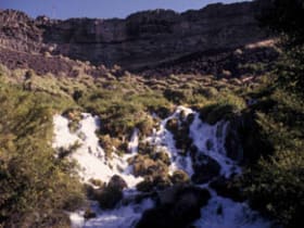
Thousand Springs State Park
19 miles away
Thousand Springs gets its name from the hundreds of springs that emerge from the basalt canyon walls above the Snake River between Hagerman and Buhl.