Badwater Basin
Badwater Basin, Death Valley National Park, CA
Death Valley, CA
Stand at the bottom of the continent on a sea of blinding white salt, 282 feet below sea level.
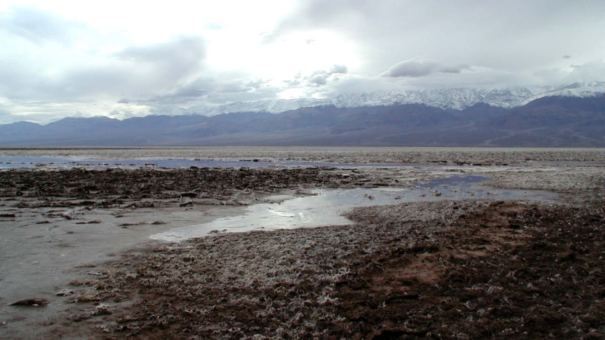
Badwater Basin is the lowest point in North America, a surreal expanse of blinding white salt lying 282 feet below sea level on the floor of Death Valley. A short boardwalk leads out onto the salt flats, where visitors can walk across the crunchy, hexagon-patterned crust and stand at the very bottom of the continent, surrounded by towering desert mountains.
High on the cliff above the parking area, a small sign marks where sea level would be, a striking reminder of just how deep the basin lies. The salt pan formed as ancient lakes evaporated and left their minerals behind, and the result is an unusual and unforgettable landscape.
What Travelers Love
- Standing at 282 feet below sea level, the lowest point in North America
- Walking out onto the vast, hexagon-patterned salt flats
- The 'Sea Level' sign high on the cliff above the basin
- Otherworldly views of salt and desert mountains
Worth Knowing
- It is inside Death Valley National Park, so an entrance pass is needed
- Summers are dangerously hot; visit in the cooler months or early morning
- Bring plenty of water; there is no shade on the salt flats
- The salt is uneven and crunchy underfoot, so wear sturdy shoes
Learn about Badwater Basin
The bottom of the continent
From the parking area, a boardwalk crosses a small spring-fed pool, the bitter, salty water that gave Badwater its name, before reaching the open salt flat. Walking out, visitors find themselves on a vast white plain patterned with polygons of salt, stretching toward the Panamint Range on the far side of the valley.
Look up and back toward the cliffs, and you can spot the 'Sea Level' sign perched far above, driving home that you are standing 282 feet below the ocean's surface. The scale, the silence, and the strange beauty make it a place unlike anywhere else.
A land of salt and heat
The salt of Badwater Basin was left behind as ancient lakes filled and evaporated over thousands of years, concentrating minerals on the valley floor. After rare rains, a thin sheet of water can turn the flat into a shimmering mirror before drying and renewing the salt polygons.
This is the hottest, driest place in North America, and summer temperatures can be deadly. The best and safest time to visit is the cooler months, or early morning, and carrying plenty of water is essential since there is no shade anywhere on the flats.
Closest Boutels
The closest Boutel™ stays, so you can turn this stop into an overnight. Each is a place we chose through independent editorial review, never a paid placement.
Sands Motel of Boulder City
Honorable Mention809 Nevada Way, Boulder City, NV
109 miles away|Learn More ›
Details
Death Valley, CA
Frequently asked questions
What is Badwater Basin?
Badwater Basin is the lowest point in North America, lying 282 feet below sea level on the floor of Death Valley National Park in California. It is a vast expanse of white salt flats, patterned with polygons of salt, ringed by towering desert mountains. A short boardwalk leads from the parking area out onto the salt, where visitors can walk across the crunchy crust and stand at the very bottom of the continent. High on the cliff above, a sign marks sea level, showing just how deep the basin lies. Formed as ancient lakes evaporated and left their minerals behind, it is a surreal and unforgettable landscape.
How far below sea level is Badwater Basin?
Badwater Basin sits 282 feet, about 86 meters, below sea level, which makes it the lowest point in North America and one of the lowest places on Earth's land surface. Standing on the salt flats, you can look up at the cliffs behind the parking area and spot a small sign marking where sea level actually is, high above your head, a vivid illustration of the depth. The extreme low elevation, combined with the surrounding mountains that trap heat, is part of why Death Valley is also the hottest and driest place in North America. The contrast of standing so far below the sea on a plain of salt is what makes Badwater so memorable.
Can you walk on the salt flats at Badwater Basin?
Yes. A boardwalk leads from the parking area across a small salty pool to the edge of the salt flats, and from there visitors are free to walk out onto the salt itself. The crust is crunchy and uneven, patterned with the famous salt polygons, so sturdy shoes are a good idea. Many people walk a good distance out to escape the crowds and take in the vast, silent expanse, though there are no marked trails and no shade at all. It is important to carry plenty of water, avoid the deadly summer heat, and keep track of your car, since the flat, featureless landscape can be disorienting. Walking on the salt is one of the great experiences of Death Valley.
When is the best time to visit Badwater Basin?
The best time to visit Badwater Basin is during the cooler months, roughly late fall through early spring, when temperatures are comfortable for walking on the shadeless salt flats. Death Valley is the hottest place in North America, and summer temperatures here regularly exceed 120 degrees Fahrenheit, which can be life-threatening, so summer visits should be limited to brief early-morning stops with plenty of water. Sunrise and sunset are especially beautiful, when low light brings out the texture of the salt polygons and colors the surrounding mountains. Whenever you go, bring far more water than you think you need, wear sun protection, and never underestimate the heat of the valley floor.
Nearby

Artists Palette
8.7 miles away
Artists Palette is a stretch of desert hills splashed with pastel greens, pinks, purples, and golds, the result of volcanic minerals oxidizing in the rock.

Zabriskie Point
13 miles away
Zabriskie Point is Death Valley most iconic overlook, a short walk from the parking area to a viewpoint over a maze of golden, wildly eroded badlands.

Mesquite Flat Sand Dunes
32 miles away
The Mesquite Flat Sand Dunes are the most accessible dunes in Death Valley, rising in graceful, rippled waves near Stovepipe Wells.