
Tillamook State Forest
26476-25842 OR-6
Tillamook, OR
A green, mossy Coast Range forest that most travelers drive straight through, not realizing it is a comeback story, a landscape reduced to a wasteland of ash by fire and then replanted, seedling by seedling, by the hands of ordinary Oregonians.
Most travelers know the Tillamook State Forest only as the green tunnel of Douglas fir they pass through on the winding drive between the Willamette Valley and the coast. It looks like ancient, untouched wilderness, mossy and deep, the Wilson River tumbling clear beside the road. But almost none of it is old. This entire forest is a rebirth, grown up over the ash of one of the worst wildfire disasters in Oregon's history.
Between the 1930s and the 1940s, a series of fires known collectively as the Tillamook Burn swept these mountains again and again, blackening hundreds of square miles and leaving a wasteland of standing dead snags and bare, eroding hillsides. What turned that ruin back into forest was not nature left alone but a deliberate, decades-long act of will. Oregonians voted to fund the replanting, and tens of millions of seedlings were set into the burned ground by hand, many of them planted by schoolchildren and volunteers. The green forest you drive through today is, quite literally, a forest the people of Oregon grew back.
What Travelers Love
- The Wilson River Trail, following the river through deep, green Coast Range forest with pools and small falls along the way
- The Tillamook Forest Center, with its climbable lookout tower and long suspension bridge over the Wilson River
- Learning that this lush forest is entirely regrown, a place people put back after fire destroyed it
- The forest's swimming holes and shaded riverbank picnic spots on a warm summer day
Worth Knowing
- This is a working forest managed for timber as well as recreation, so you may see active logging areas and closed roads
- The Coast Range is one of the wettest places in Oregon, so trails stay muddy much of the year and rain gear is wise
- Highway 6 through the forest is winding and can be foggy or icy in cold weather, so drive it with care
- The Tillamook Forest Center keeps seasonal hours and is not open year-round, so check before planning a visit around it
Learn about Tillamook State Forest
The story of the Tillamook Burn
These mountains are part of the homelands of the Tillamook and Kalapuya peoples and their neighbors, who traveled and lived across the Coast Range and its rivers long before the timber era, and whose descendants remain part of the region's Native community today. The forest is a working landscape now, but it rests on a far older human story.
The disaster began in August 1933, deep in a hot, dry summer. A fire broke out in the Coast Range and, driven by wind and drought, exploded into a firestorm that in a single ferocious run burned across hundreds of thousands of acres in little more than a day, stopped at last only when the wind died and a wet ocean fog rolled in. It was a catastrophe on a scale Oregonians had never seen.
What made it worse was that it did not end. Fire returned to roughly the same country again in 1939, and again in 1945, and by some accounts once more, a grim pattern that recurred at intervals of about six years. Together these blazes came to be called the Tillamook Burn, and they left more than half a million acres of the northern Coast Range dead and blackened, an economic and emotional wound for a state built in part on timber.
The response became one of the great restoration efforts in American forestry. In the late 1940s Oregon's voters approved a bond measure to reforest the burn, and the state launched a rehabilitation program that ran for years. Tens of millions of seedlings were planted by hand across the scorched hillsides, and school groups, families, and volunteers turned out to set young trees into the ground. Slowly the blackened land greened over, and in 1973 the recovered country was formally dedicated as the Tillamook State Forest, its name a reminder of both the loss and the recovery.
The forest and the Wilson River
The living heart of the forest is the Wilson River, which the highway follows for miles as it drops from the Coast Range crest toward the sea. Fed by the heavy rains that soak this range, the river runs cold and clear over gravel bars and through green pools, and the Wilson River Trail traces it for a long, quiet stretch, passing small waterfalls and side creeks along the way.
The Tillamook Forest Center, set beside the highway along the river, tells the whole story of the burn and the replanting. A tall replica fire lookout tower stands at one end of the building, the kind of tower from which spotters once watched for the smoke that meant disaster, and a long pedestrian suspension bridge crosses the Wilson River to reach the trail and a campground on the far bank.
The forest today is a working one, managed for timber harvest as well as for recreation, which is part of what makes it unusual. It is not a preserve frozen in place but a landscape actively used and tended, its regrown trees now old enough to cut, the cycle that began with the replanting still turning.
Wildlife in a regrown forest
The replanted forest has filled back in with the classic life of the Oregon Coast Range. Roosevelt elk move through the clearings and along the river bottoms, black-tailed deer are common, and black bear range the timber, though they mostly keep out of sight. The recovered woods have become a full habitat again, not just a stand of trees.
The Wilson River is prized by anglers, running with winter steelhead and salmon that push up from the sea, and along its banks you may spot the American dipper walking underwater to feed and the flash of a kingfisher over a pool. Ospreys and bald eagles hunt the river corridor as well.
Overhead and among the trees, the regrown forest supports the pileated woodpecker, that crow-sized bird hammering rectangular holes into standing snags, along with owls and the small forest songbirds of the Northwest. That the burned wasteland now holds so much life is the quiet proof of how thoroughly the forest came back.
Season by season
Spring greens the forest brilliantly and swells the Wilson River and its side creeks, with wildflowers along the trails, though the Coast Range is at its wettest and the mud is deep.
Summer is the prime time, when the river's pools become swimming holes, the campgrounds fill, and the shaded trails offer cool relief from valley heat, all under the dependable dry stretch of the northwest summer.
Fall brings the return of the rains, thinning crowds, and the first runs of migrating fish into the river, with the bigleaf maples turning gold along the water.
Winter is wet, gray, and often foggy, and the winding highway can turn icy, but the forest is at its mossiest and greenest, and the storm-fed river runs high and loud for those who don't mind the rain.
Closest Boutels
The closest Boutel™ stays, so you can turn this stop into an overnight. Each is a place we chose through independent editorial review, never a paid placement.
Details
Tillamook, OR
Frequently asked questions
What is there to do in the Tillamook State Forest along the Wilson River?
The Wilson River corridor through the Tillamook State Forest, in the Coast Range between Portland and the coast, is a green playground of hiking, riverside swimming holes, camping, and fishing. The centerpiece is the long Wilson River Trail, which follows the river through lush forest, and the free Tillamook Forest Center makes a great starting point. It is an easy, scenic escape into a forest that has famously regrown after devastating wildfires.
What is the Wilson River Trail like?
It is a beautiful riverside path of roughly twenty miles with several trailheads, so you can walk a short, easy stretch or a longer, hillier section as you like. It winds through shady, mossy forest past creeks and footbridges, with many swimming holes along the way. The most pleasant months are spring through fall. Bring water and sturdy shoes, since some sections can be steep, overgrown, or eroded.
Where are the swimming holes, and are they safe?
Popular spots line the Wilson River, including areas near the Forest Center footbridge and other bridges, with shallow, gentle edges good for kids and deeper pools nearby. The catch is that this is cold mountain river water, cold enough to cause a gasp and cold-water shock, and some spots have rocks, rope swings, and current. Never dive into water of unknown depth, ease in slowly, supervise children closely, and stay out during high spring flows.
What is the Tillamook Forest Center?
It is a free interpretive center along the Wilson River with engaging exhibits on the great fires that once burned this forest and the decades-long effort to bring it back, plus a towering replica fire-lookout tower to climb and a long suspension bridge over the river. It is an excellent family and rainy-day stop, and it doubles as a trailhead for the Wilson River Trail and its swimming holes just across the bridge.
Are there good hikes and campgrounds in the Tillamook State Forest?
Yes. Beyond the riverside trail, steep climbs like Kings Mountain and Elk Mountain reward strong hikers with sweeping summit views, sometimes reaching to distant volcanoes on clear days, so come prepared with water and good footwear. For overnight stays, forest campgrounds such as Jones Creek and Keenig Creek offer rustic sites near the river, many first-come, first-served, so arrive early on summer weekends.
Outside the Park
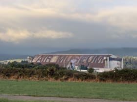
Tillamook Air Museum
11 miles away
The blimp hangar itself is the attraction: it's so large that visitors report seeing clouds form inside on humid days.
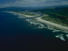
Nehalem Bay State Park
21 miles away
A four-mile sand spit just south of Manzanita, off US-101, sealing quiet Nehalem Bay off from the open Pacific.

Manzanita Beach
23 miles away
Seven miles of wide, uncrowded sand curving south from Manzanita beneath Neahkahnie Mountain, one of the highest headlands on the Oregon coast.