
Poverty Point World Heritage Site
6859 LA-577, Pioneer, LA
Pioneer, LA
A vast set of curved ridges and towering earthen mounds shaped by hand more than three thousand years ago, one of the oldest and most remarkable places built by people in all of North America.
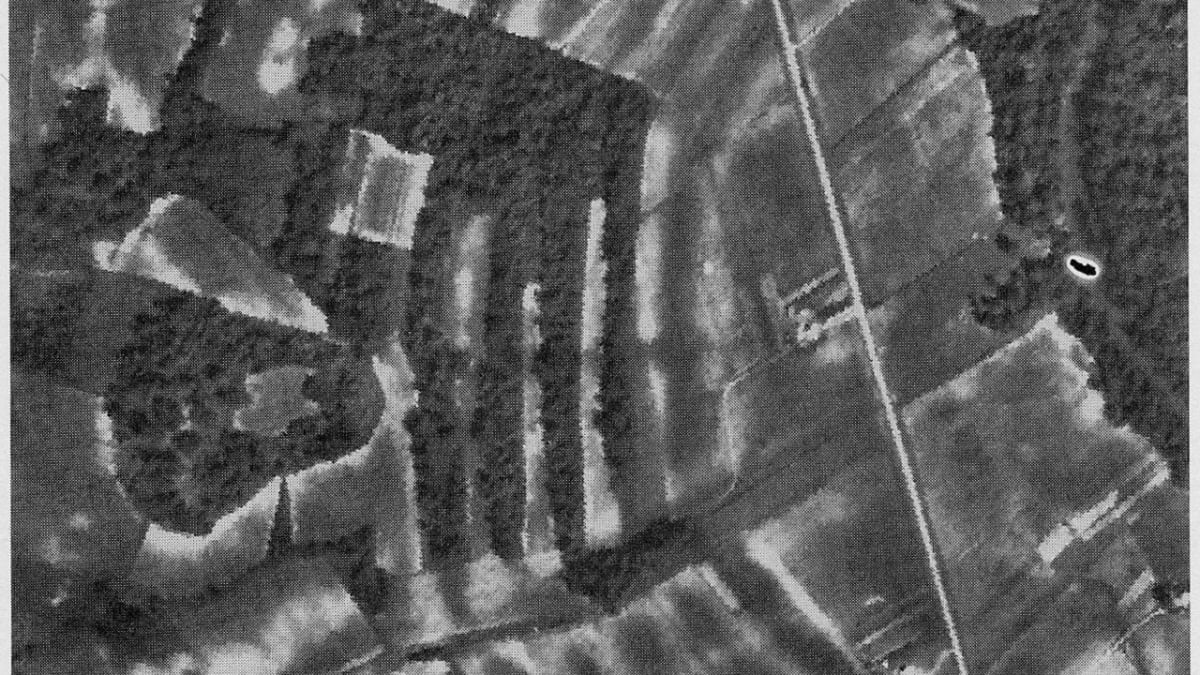
Poverty Point is one of the great surprises of American archaeology, a set of enormous earthworks raised by hand on a low ridge in northeast Louisiana more than three thousand years ago. Its builders were hunters, fishers, and gatherers, not farmers, which makes the scale of what they accomplished all the more astonishing. They shaped six concentric half-circle ridges and several towering mounds, moving millions of basket loads of soil without the wheel, without draft animals, and without metal tools.
The largest of the mounds, known as Mound A, rises about seventy feet and is one of the biggest earthen structures ever built in North America. In 2014 the site was inscribed as a UNESCO World Heritage Site, placing this quiet corner of Louisiana on a list alongside the pyramids and Stonehenge. To walk the ridges today is to stand inside a plan drawn by people whose names are lost but whose vision still shapes the ground.
What Travelers Love
- Climbing to the top of Mound A and looking out over the whole earthwork plan
- Walking or riding the tram out along the great curved ridges
- Handling replica spear points and cooking stones in the exhibit hall
- The sheer age of the place, older than the Roman Colosseum and the pyramids of Egypt at Giza
Worth Knowing
- This is a place of deep Indigenous heritage; treat the mounds and grounds with respect and stay on marked paths
- The site is spread out and largely open, so bring water, a hat, and sun protection in warm months
- A tram tour makes the distances easy; check the schedule before you arrive
- Northeast Louisiana summers are hot and humid, and biting insects are active, so plan for both
Learn about Poverty Point World Heritage Site
The people who built Poverty Point
The people who raised Poverty Point lived here roughly between 1700 and 1100 before the common era. They did not farm; instead they thrived on the rich resources of the rivers and swamps, taking fish, turtles, deer, waterfowl, and wild plants from a landscape of extraordinary abundance. That a society without agriculture could organize the labor to build monuments on this scale overturned old assumptions about who could create such works and when.
The design itself is deliberate and sophisticated. Six nested C-shaped ridges open toward Bayou Macon, once holding the homes of the community, and beyond them stand the mounds. Poverty Point stands within the long, living story of Indigenous Louisiana, home today to the Chitimacha, Tunica-Biloxi, Coushatta, Houma, Choctaw, Caddo, and other nations whose ancestors shaped this land for thousands of years.
A trading hub of the ancient South
Poverty Point was far more than a local settlement. It sat at the center of a trading network that reached across a huge swath of the continent. Archaeologists have found stone here that came from hundreds of miles away, copper from the Great Lakes region, gray flint from the Ohio River valley, soapstone from the southern Appalachians, and colorful cherts and quartz carried in from many directions.
Because good stone for tools is scarce in the Louisiana Delta, the people of Poverty Point imported it and worked it into blades, drills, and beads with remarkable skill. They also fashioned small baked-earth cooking balls, sometimes called Poverty Point objects, which they heated in fires and used to bake food in earth ovens, a clever solution in a land with little rock. The volume and variety of these goods tell of a community that was a magnet, a place people traveled to and traded through across a vast region.
The mounds and the mystery of Mound A
The great centerpiece is Mound A, a bird-shaped mound that rises about seventy feet and contains an enormous volume of earth. What makes it especially astonishing is the evidence that much of it may have been built in a remarkably short span of time, with no sign that rain interrupted the work between layers. That would mean thousands of people gathered and moved millions of basket loads of soil in a sustained, coordinated effort, a feat of organization that still amazes researchers.
Other mounds dot the site, including the older Mound B and the flat-topped Mound C set among the ridges. Standing atop Mound A, you can take in the whole plan at once, the sweep of the ridges below and the plaza they enclose. Much about the site remains a mystery, including exactly how the community was led and why the place was eventually left, and that open question is part of what makes a visit so absorbing.
Wildlife, the land, and the seasons
The site sits on Macon Ridge above the surrounding lowlands, a mix of open grassy earthworks, hardwood stands, and the wooded edge of Bayou Macon. White-tailed deer, rabbits, and armadillos move through the grounds, hawks and vultures ride the thermals overhead, and in the warmer months the bayou hums with frogs, turtles, and wading birds. Songbirds fill the tree lines in spring and fall.
Spring and fall are the most comfortable times to walk the ridges, with mild air and long light that rakes across the earthworks and shows their shape. Summer here is hot and humid, so an early start and the tram help. Winter is quiet and often clear, the bare trees opening up long views across the mounds, a fine season to have the ancient plan almost to yourself.
Closest Boutels
The closest Boutel™ stays, so you can turn this stop into an overnight. Each is a place we chose through independent editorial review, never a paid placement.
Details
Pioneer, LA
Frequently asked questions
What is the Poverty Point World Heritage Site?
The Poverty Point World Heritage Site, in northeastern Louisiana near Epps, preserves the remains of an astonishing ancient Native American settlement, one of the most important archaeological sites in North America and a designated World Heritage Site. Built by Native peoples over three thousand years ago, Poverty Point features monumental earthworks, including huge concentric earthen ridges and large mounds, created with remarkable engineering and effort long before many other ancient civilizations, by a sophisticated culture of hunter-gatherers. The scale and age of these earthworks make it a place of profound significance and reverence. A monumental and sacred ancient site, it awes and moves visitors. With its ancient earthworks, the site offers a compelling destination in Louisiana.
Who built Poverty Point and why is it significant?
Poverty Point was built by Native American peoples over three thousand years ago, a sophisticated culture who, remarkably, created its monumental earthworks, including massive concentric ridges and large mounds, without the agriculture, metal tools, or draft animals that built many other ancient monuments, moving enormous amounts of earth by hand. Its scale, age, and the achievement it represents make it one of the most significant archaeological sites in North America and a World Heritage Site, a testament to the ingenuity of these ancient peoples. It remains significant to Native peoples today. Understanding this heritage deepens a visit to Poverty Point in Louisiana.
What can you see at the Poverty Point World Heritage Site?
You can see the monumental ancient earthworks, including the huge concentric earthen ridges and large mounds, explore the site by walking or a tram tour, and visit a museum with exhibits and artifacts that interpret this remarkable ancient culture. The vast earthworks, the mounds, the museum and artifacts, and the interpretation of this astonishing ancient achievement are the draws, offering a profound and educational experience. The scale of the earthworks is the highlight. Approaching the site with respect for its significance enriches a visit to Poverty Point in Louisiana.
How should visitors treat the Poverty Point World Heritage Site?
Because Poverty Point is an ancient, sacred site of profound significance and a World Heritage Site, visitors should treat it with respect and reverence, staying on designated paths and tram routes, not climbing on or disturbing the earthworks and mounds, and appreciating them as the monumental and sacred works they are. Honoring the extraordinary achievement and the peoples who built it, and their descendants, respects the site. Approaching Poverty Point with respect ensures a meaningful visit in Louisiana.
When is the best time to visit the Poverty Point World Heritage Site?
The milder months of fall through spring are the most pleasant for exploring the outdoor earthworks in Louisiana's climate, avoiding the intense summer heat and humidity, with comfortable weather for walking or the tram tour and appreciating the scale of the site, while the museum welcomes visitors year-round. Because tours and hours can vary, checking current information before you go is wise. For the most comfortable visit, aim for fall through spring at the Poverty Point World Heritage Site in Louisiana.
Nearby

Black Bayou Lake National Wildlife Refuge
38 miles away
Black Bayou Lake is a classic Louisiana cypress lake, its dark water studded with bald cypress and tupelo trees and carpeted in spots with American lotus and lily pads.

Vicksburg National Military Park
38 miles away
The setting is as much the story as the battle: Vicksburg sits on high loess bluffs at a hairpin bend of the Mississippi River, and holding that ground meant holding the river itself.
Louisiana Purchase Gardens and Zoo
42 miles away
This Monroe zoo is just the right size for a family with little ones: shaded, walkable, and laid out along bayou waterways so you can see it all in an afternoon without exhausting anyone.