
Pony Express Trail, UT-36 corridor
Stockton, UT
Stockton, UT
A long dirt road across the loneliest desert in Utah, tracing the same route riders once galloped to carry the mail west.
The Pony Express was short-lived but unforgettable: for about eighteen months in 1860 and 1861, relays of hard-riding young men carried the mail some 1,900 miles between Missouri and California, changing horses at a chain of stations spaced across the frontier. A long stretch of that route ran straight across Utah's West Desert, and today a graded backcountry byway lets you drive it, following the same lonely line the riders once rode.
West of the Stockton and Tooele area the road leaves the last towns behind and strikes out across basin-and-range desert, one broad sagebrush valley after another divided by low mountains. Stone monuments and the low ruins of relay and home stations mark the way, and out here the emptiness is the point: wide horizons, grazing wild horses, and at night a sky as dark as any in the Lower 48.
What Travelers Love
- Driving a long, empty desert road that follows the actual 1860 mail route
- Stone markers and station ruins that tell the story of the riders
- Herds of wild horses grazing the open range and dry valleys
- Some of the darkest, most star-filled night skies in the state
Worth Knowing
- This is remote country with long stretches of graded dirt, so carry water, food, and a full tank of fuel
- There are few services once you leave the towns, and cell coverage is spotty to none
- Much of the route is passable to a regular car in dry weather, but rain and snow can turn it to slick mud
- Tell someone your route and expected return before heading into the desert
Learn about Pony Express Trail, UT-36 corridor
The riders and the route
The Pony Express began in April 1860 as a bold attempt to speed mail across the continent before the transcontinental telegraph existed. Riders carried a lightweight leather mochila slung over the saddle, changing horses every ten to fifteen miles at relay stations and handing off to a fresh rider after a long stretch. Working in relays around the clock, they could move a letter from Missouri to California in about ten days, a speed that seemed almost miraculous at the time.
The desert crossing in Utah was among the hardest stretches on the whole line. Water was scarce, the stations were far apart, and the country was open and exposed. When the transcontinental telegraph was completed in October 1861, the Pony Express was made obsolete almost overnight and shut down after only about eighteen months. It carried the mail for barely a year and a half, yet it left an outsized mark on the story of the American West.
Station sites along the byway
The graded route is dotted with the locations of the old relay and home stations, some marked by stone monuments, others by low ruins of rock and adobe worn down by more than a century and a half of weather. Names like Faust, Simpson Springs, and Fish Springs still label the map, each one a place where riders once swapped a spent horse for a fresh one and pushed on across the next valley.
Simpson Springs is one of the best-preserved sites, with a reconstructed stone station standing on the same reliable spring that made it a natural stop. Standing beside these markers, with nothing but sagebrush and mountains in every direction, it is easy to feel how far from anywhere the riders were, and how much they depended on each small oasis of water strung across the desert.
Wild horses and desert life
The West Desert is home to herds of wild horses that range across these public lands, and it is common to spot bands of them grazing the valley floors or watching from a rise as you pass. They are descendants of ranch and Native stock turned out over generations, and they belong to the open country now, managed as part of the region's wild-horse herds.
The rest of the desert's life is quieter but no less real. Pronghorn drift across the flats, jackrabbits and kit foxes work the sage, and golden eagles and hawks ride the thermals overhead. In the wet meadows around the springs, migrating birds gather, and the Fish Springs area in particular draws waterfowl to its marshes, an unexpected splash of green and water in a very dry land.
Driving it, and the dark sky
This is a full-day backcountry drive, not a quick side trip. Most of the route is graded dirt that a regular car can handle in dry weather, but there are no services along the way, so the smart move is to top off fuel, carry plenty of water and food, and let someone know your plan. Rain and snow can turn the surface to greasy mud, so check conditions before you go and be ready to turn back.
The reward for the effort comes after dark. Far from any city glow, the West Desert has some of the blackest skies in the state, and on a clear, moonless night the Milky Way arches from horizon to horizon over the sagebrush. It is a fitting place to end a day on the trail, under the same star-filled sky the riders once navigated by.
Closest Boutels
The closest Boutel™ stays, so you can turn this stop into an overnight. Each is a place we chose through independent editorial review, never a paid placement.
Details
Stockton, UT
Frequently asked questions
What is the Pony Express Trail in Utah?
The Pony Express Trail across Utah's remote west desert follows the historic 1860-61 route of the legendary mail service, whose riders carried letters across the frontier at a gallop. Today it is a long backcountry scenic and historic driving route, largely on graded dirt roads, dotted with restored station sites and interpretive markers amid vast, empty desert. It offers a genuine sense of the isolation and grit of the Pony Express era, along with big-sky scenery and abundant solitude.
What can you see along the Pony Express Trail?
Driving the route, you can stop at restored and marked station sites, such as Simpson Springs, where riders once changed horses, read interpretive signs about the mail service and the desert's history, and take in sweeping views of the West Desert. Wild horses and pronghorn antelope roam the area, and the remote skies are wonderfully dark at night. Nearby historic sites like Camp Floyd add context to this evocative journey through frontier history.
Is the Pony Express Trail safe to drive?
It requires serious preparation, because this is extremely remote country with no services, water, or cell coverage for long stretches. Come fully self-sufficient with a full tank of gas, plenty of water and food, a spare tire, and a good map, and tell someone your route and expected return. The dirt road can become impassable mud when wet, so avoid it in or after rain. A high-clearance vehicle is helpful, and you should never rely on finding help along the way.
When is the best time to drive the Pony Express Trail?
Spring and fall offer the most comfortable temperatures for the long, exposed drive, while summer brings intense desert heat and winter can bring cold, snow, and muddy roads. Dry, settled weather is essential, both for comfort and to keep the dirt road passable. Give yourself most of a day for the route, start early, and check current road and weather conditions before setting out into this remote landscape.
Where does the Utah Pony Express Trail begin?
The route generally begins near Fairfield, southwest of Salt Lake City and Utah Valley, close to the historic Camp Floyd site, and heads west across the desert toward the Nevada border. Because it is a long backcountry byway, most travelers drive a portion rather than the whole thing. Starting from the Fairfield and Camp Floyd area lets you pair the historic fort and museum there with a scenic, adventurous drive along the old mail route.
Nearby
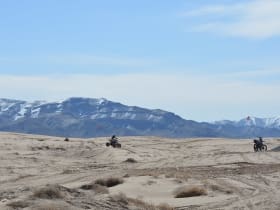
Little Sahara Recreation Area
36 miles away
Little Sahara Recreation Area covers 60,000 acres of BLM land northwest of Nephi in Juab County and preserves one of the largest active sand dune systems in Utah.
Wheel Shale Trilobite Beds
37 miles away
The Wheeler Shale formation near Delta contains abundant trilobite fossils from the Cambrian period, approximately 505 million years ago.
Topaz Mountain
38 miles away
Topaz Mountain is a rhyolite dome where golden topaz crystals weather out of the volcanic rock and can be found on the surface or dug from the loose rhyolite.