
Pinnacles National Park
Pinnacles Visitor Center, Paicines, CA
Central Coast (Soledad / Hollister)
Some parks are about one big view. Pinnacles is about a whole broken landscape. Sharp rock spires and jagged crags rise straight out of the dry, golden hills east of the Salinas Valley, and between them run deep gorges choked with fallen boulders. The odd part is that the rock here did not form where it stands. It is the eroded remains of an ancient volcano that was split by the San Andreas Fault, the long crack in the earth where two great slabs of the planet grind past each other, and one half of that volcano was slowly carried some 200 miles north to where it sits today.
This became a national park in 2013, one of the newest in the country, though it was first protected as a national monument back in 1908 by President Theodore Roosevelt. Wedged into the rock are the park's famous talus caves, dark passages formed where huge boulders wedged into narrow canyons, and high above the spires soar California condors, one of the rarest birds on earth, riding the warm air on wings nearly ten feet across. Add hundreds of rock-climbing routes and a spring show of wildflowers, and you have a small, wild park that most people have never heard of.
Learn about Pinnacles National Park
The Park
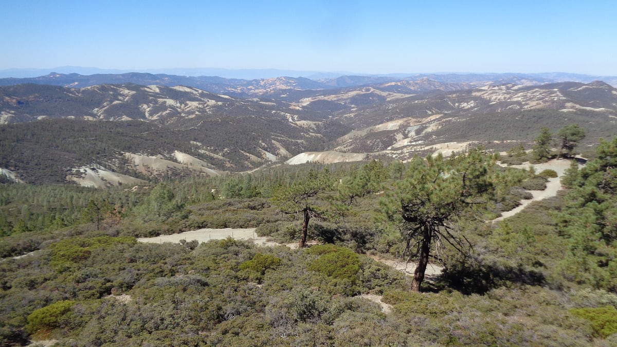
Pinnacles protects a jumble of towering spires, sheer walls, and rounded knobs, all carved out of the roots of an old volcano. The rock is a rough volcanic stone called breccia, and over millions of years wind and water have weathered it into the fantastic shapes that give the park its name. The San Andreas Fault runs right along the edge of the park, and it is the reason this rock traveled so far. As the two sides of the fault slid past each other, they hauled the western half of the volcano roughly 200 miles north from where it erupted, near present-day Southern California. Its matching half still sits down south, and the way the two pieces line up is one of the clearest proofs anywhere of just how far the fault has moved the land.
Down among the spires, streams tunneling beneath fallen boulders created the park's talus caves, dark and cool passages you can scramble through with a flashlight. High above, the crags and the warm rising air suit the California condor, and Pinnacles is one of the main sites where these giant birds, once nearly extinct, are released back into the wild. This is California's least-visited national park and one of the most dramatic landscapes most people have never heard of, set almost exactly halfway between San Francisco and Los Angeles in the Gabilan Mountains.
Away from the rock, Pinnacles is classic California chaparral, dense with manzanita, chamise, and gray pine, and home to bobcats, gray foxes, and a surprising number of wild bee species. Spring turns the slopes green and studs them with wildflowers, while summer bakes brown and hot. It is a compact park, but the trails are steep and rocky, and the two entrances sit on opposite sides of the spires with no road connecting them, so a little planning goes a long way.
How to Enter
- East Entrance, off CA-25 near Hollister, is the main way in and stays open year-round. It reaches the Pinnacles Visitor Center, the Bear Gulch area, the reservoir, and the Bear Gulch talus caves, and it generally has the most services.
- West Entrance, off CA-146 from Soledad, is also open year-round and reaches the Chaparral area and the trailheads for the High Peaks and the Balconies Cave. It is quieter, with fewer services.
- Important: the two entrances are NOT connected by any road inside the park. To get from one side to the other you must drive all the way around the outside, which takes about an hour, so pick your entrance based on the trails you want. From the San Francisco Bay Area, come south on US-101 and cut over on CA-25 to the east side. From the Salinas Valley and Monterey, reach the west side through Soledad on CA-146.
Things to Do
- The High Peaks Trail is the park's signature hike, an 8.7-mile loop that climbs right up among the spires, with dramatic hand-and-foot scrambling along narrow ledges and iron rungs bolted into the rock. It is strenuous but unforgettable.
- Bear Gulch Caves, on the east side, is a 1.5-mile loop that leads you with a flashlight through a talus cave and up to a small reservoir tucked among the crags. Parts of the cave close seasonally to protect roosting bats.
- The Condor Gulch Overlook is a 2.2-mile round trip that climbs to a viewpoint where condor sightings are common. Watch the high spires for a giant bird soaring past, and look for the numbered tags on its wings.
- Balconies Cave, on the west side, is a 2.4-mile loop through a different talus cave system, usually cooler and quieter than Bear Gulch and a fine choice on a hot day.
History
Long before it was a park, this land was home to the Chalon and Mutsun peoples, two groups of the Ohlone, who lived and traveled through the Gabilan Mountains and the valleys around them for thousands of years. The spires, the springs, and the oak-dotted hills were part of their world, and their descendants remain part of the region today. Their long connection to this place came first, and it deserves respect.
In the late 1800s a homesteader named Schuyler Hain settled near the rocks and fell in love with the strange spires and caves. He guided visitors through them and campaigned to protect the area, earning the nickname the Father of Pinnacles. His effort paid off in 1908, when President Theodore Roosevelt set the land aside as Pinnacles National Monument, one of the early monuments created under the new Antiquities Act.
In the 1930s the Civilian Conservation Corps went to work here, building many of the trails, steps, and stonework that hikers still use, including the rugged routes through the High Peaks and the paths that thread the talus caves. For more than a century the monument grew piece by piece as land was added around the original core.
The land was finally redesignated as a national park in 2013, making Pinnacles one of the newest additions to the national park system. By then it had also become something more urgent: a refuge for the California condor, released here as part of the long fight to bring the species back from the brink of extinction.
Little-Known Facts
- The rock at Pinnacles started out about 200 miles south, near Southern California, and was carried here by the San Andreas Fault. Its matching half, called the Neenach Formation, still sits back where the volcano first erupted.
- Pinnacles has no true caves dissolved out of stone. Its talus caves are simply the gaps left when giant boulders tumbled into narrow canyons and wedged overhead, roofing the passages below.
- The California condor is the largest land bird in North America, with a wingspan approaching ten feet. In the 1980s the entire wild population fell to just a couple dozen birds before a breeding program pulled the species back.
- Pinnacles is one of the least-visited national parks in the country, which means big-park scenery with small-park crowds.
- The park is a hotspot for wild bees, with well over 400 species recorded, one of the highest known bee diversities anywhere in the world for its size.
- The two entrances feel like two different parks. There is no road through the middle, so a short trail between the sides can be walked, but a car cannot make the trip without an hour's drive around the outside.
- Townsend's big-eared bats roost in Bear Gulch Cave, and the seasonal cave closures exist mainly to protect them during sensitive times of the year.
- Pinnacles sits almost exactly halfway between San Francisco and Los Angeles, an easy detour off the busy US-101 corridor that most road trippers drive right past.
Plan Your Visit
- An entrance fee applies (per vehicle, good for seven days); check the park website for current rates, and interagency annual passes are accepted.
- The East Entrance (Hollister, CA-25) reaches the Pinnacles Visitor Center, Bear Gulch, and the reservoir. This is the main entrance and generally has the most services.
- The West Entrance (Soledad, CA-146) reaches the Chaparral area and the trailheads for the High Peaks and Balconies Cave. It is quieter, with fewer services.
- The two sides of the park are NOT connected by road, so choose your entrance based on the trailhead you want, and know that reaching the other side means about an hour of driving around.
- Nearest services are in Soledad, about 25 miles from the west side, and Hollister, about 32 miles from the east side. Fill up, and pack a flashlight and plenty of water before you go.
Inside the Park
High Peaks Trail
A steep, dramatic hike among the volcanic spires, with condors soaring overhead.
Bear Gulch Cave
A talus cave explored by flashlight, past a seasonal waterfall up to Bear Gulch Reservoir.
Balconies Cave
A boulder cave on the west side, hiked as a loop beneath the Balconies climbing cliffs.
California Condors
North America largest land bird, reintroduced here and often seen soaring over the High Peaks.
Details
Central Coast (Soledad / Hollister)
Frequently asked questions
Is there an entrance fee, and when is the park open?
Yes. Pinnacles charges a per-vehicle entrance fee that is good for seven days, and interagency annual passes are accepted. Check the National Park Service website for the current rate. The park is open year-round through both the east and west entrances, though individual trails, caves, and roads can close temporarily for weather, flooding, or wildlife protection.
Are the two entrances to Pinnacles connected?
No, and this is the single most important thing to know before you go. Pinnacles has an east entrance near Hollister and a west entrance near Soledad, but no road connects them inside the park. You cannot drive from one side to the other through Pinnacles. Reaching the opposite side means driving all the way around the outside, which takes about an hour, so choose your entrance based on the trails you want to hike.
Do I need a flashlight for the caves, and are they always open?
Yes, bring a flashlight or headlamp for the talus caves at Bear Gulch and the Balconies. They are genuinely dark inside, with uneven footing. Parts of the caves may close seasonally to protect roosting bats, and they can also flood after heavy rain, so check the current cave status on the park website before you count on getting through.
Can I really see California condors here?
You have a real chance. Pinnacles is one of the main release sites for the endangered California condor, and a resident flock nests and roosts in the park. Watch the high spires, especially around the High Peaks and Condor Gulch Overlook, for a very large bird soaring on the warm air. Look for the numbered tags on its wings, which is how researchers track each bird. Sightings are never guaranteed, but patient visitors are often rewarded.
How hot does it get, and how do I stay comfortable?
Summers at Pinnacles are very hot, often well into the high 90s or above, with little shade on the exposed rock. Hike early in the day, carry more water than you think you need, wear a hat, and rest during the hottest afternoon hours. Save the strenuous High Peaks loop for a cool morning. In the heat of summer, a shaded cave hike is a smarter midday choice than the open spires.
When is the best time of year to visit?
Spring is the standout. The chaparral turns green, wildflowers cover the slopes, streams run, and temperatures are mild. Fall and winter are also pleasant and quiet, with cooler days perfect for hiking. Summer is best avoided for daytime hikes because of the heat. For the best mix of comfortable weather, wildflowers, and open caves, aim for spring.
How much time do you need at Pinnacles?
You can get a good taste of one side in a half day, hiking to a cave or an overlook. To hike a longer loop like the High Peaks, explore a talus cave, and not feel rushed, give it a full day. Because the two entrances are not connected, most visitors pick one side per trip rather than trying to see both in a single day.
Is there lodging or camping inside the park?
Camping is available at the Pinnacles Campground on the east side, near Hollister, which has tent and RV sites and a seasonal pool. There is no hotel or lodge inside the park, so for a room you will look to nearby towns such as Hollister, Soledad, and the surrounding Salinas Valley. Book ahead in spring, the busiest season.
Are pets allowed on the trails?
Pets are welcome in the campground, parking areas, and along paved roads, but they are not allowed on the park's hiking trails or in the caves. That keeps wildlife, including the condors, safe and undisturbed. If you bring a dog, plan for it to stay in the developed areas, and never leave a pet in a hot vehicle.
Is Pinnacles good for rock climbing?
Yes, it is one of California's classic climbing destinations, with hundreds of routes on the volcanic spires. The rock can be crumbly, so climbers take extra care and use proper gear and judgment. Even if you do not climb, the towering formations make Pinnacles a striking place to watch climbers work their way up the crags.