
Goosenecks State Park
UT-316, Mexican Hat, UT
Mexican Hat, UT
A single overlook onto a river coiled back on itself so tightly it travels miles to gain almost no ground.
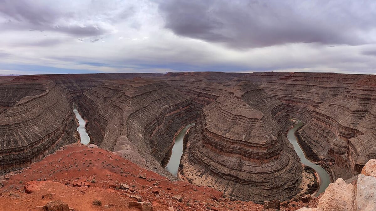
Goosenecks is one of the finest examples anywhere of what geologists call an entrenched meander. Standing at the overlook, you look down more than a thousand feet to the San Juan River winding through the canyon in tight, hairpin loops, doubling back on itself so completely that it travels several miles of river to cover barely a mile as the crow flies. From above, the bends look like a green ribbon folded again and again on the desert floor.
The park itself is little more than that overlook, a rim with room to sit and take in the view, and that plainness is its charm. There are no crowds, no fanfare, just the enormous silent canyon and, at night, a bowl of stars. It sits in the heart of Utah's remote southeast, within the homeland of the Diné, close to Monument Valley and the Bears Ears country.
What Travelers Love
- The sheer drama of the river folded back on itself far below your feet
- A wide-open overlook with room to sit, take it in, and stay a while
- Sunrise and sunset, when the canyon walls glow and the shadows deepen
- Some of the darkest, clearest night skies in the country
Worth Knowing
- The rim is unfenced in places, so keep well back from the edge, especially with children
- It is a bare, exposed spot with no shade and no services, so bring water
- The road in is short but the whole area is remote, so plan fuel and supplies ahead
- You look down on the river rather than reaching it; canyon access is elsewhere
Learn about Goosenecks State Park
How the river tied itself in knots
Long ago the San Juan River wandered across a flat, low plain in these lazy, looping bends, the way slow rivers do on level ground. Then the whole region began to rise, lifted by forces deep in the earth, and as the land pushed up the river kept to the path it already had, cutting straight down into the rock rather than shifting course. Over millions of years it sawed its meandering channel deep into the stone, and the loose loops of a lowland river became the sheer, entrenched goosenecks you see today.
The canyon walls lay bare hundreds of millions of years of rock, layer stacked on layer, each a chapter of ancient seas, tidal flats, and shifting shorelines. Because the river cut so deep and so tightly, the exposure is unusually complete, which is why geologists prize this spot and why the whole scene has the look of a diagram of deep time made real.
The people of the canyon country
This corner of Utah lies within the ancestral and present homeland of the Diné, the Navajo people, whose Nation borders the river to the south, and of the Ute and Southern Paiute peoples who also traveled this country. The San Juan and its side canyons have long been part of their landscape, named and known in ways that outlast any state park boundary.
Older still, the Ancestral Puebloan people farmed the river bottoms and mesa tops here for centuries, building masonry dwellings and granaries and leaving rock art on the canyon walls, before moving on around eight hundred years ago. Their descendants live among today's Pueblo nations. Please treat any sites, structures, or rock art in the wider region as sacred, fragile, and never to be touched or disturbed.
The view, and the river below
The visit is really about the overlook and the time you give it. Sit on the rim and let your eye follow the river through its coils, and watch the canyon change as the light moves, the shadows filling and draining the folds hour by hour. A short walk along the rim opens new angles on the bends, and a small interpretive area explains what you are seeing.
Far below, the San Juan itself is a favorite of river runners, who float multi-day trips through this canyon and camp on its sandbars, drifting through the very loops you look down on. From the rim they appear as tiny specks on a green thread, a reminder of just how deep and vast the canyon really is.
Desert life, seasons, and dark skies
The rim is high desert, sparse and tough, with scattered sagebrush, saltbush, and hardy wildflowers after rain. Ravens and hawks ride the canyon updrafts, lizards dart across the warm rock, and coyotes, jackrabbits, and the occasional bighorn sheep range the wider country below.
Summer days are hot and glaring with no shade at all, so morning and evening are the times to come, while winter brings sharp cold and sometimes a dusting of snow on the red rock. Spring and fall are the kindest seasons. And because the park sits so far from any city lights, the night sky here is spectacular, with the Milky Way pouring right down into the dark of the canyon.
Closest Boutels
The closest Boutel™ stays, so you can turn this stop into an overnight. Each is a place we chose through independent editorial review, never a paid placement.
Details
Mexican Hat, UT
Frequently asked questions
What is Goosenecks State Park?
Goosenecks State Park is a small park near Mexican Hat in southeastern Utah with one jaw-dropping feature: an overlook of the goosenecks of the San Juan River, where the river snakes back on itself in tight, dramatic loops, carving canyons more than a thousand feet deep below. It is a textbook example of entrenched river meanders and a striking, quick stop, offering a stunning geological spectacle for very little effort right from the rim.
What can you do at Goosenecks State Park?
The main activity is taking in and photographing the remarkable view of the twisting San Juan River far below from the overlook. The park also offers primitive camping for those wanting a stark, quiet night under exceptionally dark skies, with basic facilities like vault toilets. It is more a brief scenic stop than a place for long hikes, but the view alone makes it well worth the short detour on a southeastern Utah road trip.
Is Goosenecks State Park safe?
The overlook sits atop steep, largely unfenced cliffs with a drop of over a thousand feet to the river, so caution is essential. Stay well back from the edge, watch your footing on the rocky rim, and keep children and pets close at all times. There are no barriers in many spots, so treat the edge with the seriousness such a dangerous drop deserves. Enjoyed carefully from a safe distance, the view is unforgettable.
When is the best time to visit Goosenecks State Park?
Because it is a quick overlook stop, it can be enjoyed year-round, though spring and fall offer the most comfortable temperatures, and midday to afternoon light nicely illuminates the river winding through the canyon below. There is a small day-use or camping fee. Clear weather offers the best views and photos, and pairing it with the nearby Moki Dugway and Valley of the Gods makes an easy, scenic outing.
What is near Goosenecks State Park?
Goosenecks lies near Mexican Hat, close to a remarkable cluster of southeastern Utah sights: the steep, thrilling Moki Dugway road, the buttes of Valley of the Gods, and iconic Monument Valley a short drive away, with Natural Bridges National Monument within reach as well. Together they form a spectacular loop through the Bears Ears region, so the Goosenecks make a natural, brief but memorable stop on a broader tour of the area.
Outside the Park

Valley of the Gods
3.8 miles away
Valley of the Gods is a remote BLM road through a cluster of isolated sandstone buttes, mesas, and spires that resembles Monument Valley but with none of the crowds or commercial infrastructure.

Moki Dugway, Valley of the Gods
6.8 miles away
The Moki Dugway (UT-261) descends 1,200 feet in 3 miles off Cedar Mesa on a graded dirt road with switchbacks above Valley of the Gods.

Bears Ears National Monument
24 miles away
Bears Ears encompasses a vast sweep of canyon country in the Colorado Plateau, with the Bears Ears Buttes as the spiritual center for five tribal nations.